Vandalism of Data Buoys
NOAA National Data Buoy Center
Data Buoys
Data buoys are floating devices, either drifting or anchored, that are deployed by governmental or recognized scientific organizations or entities for the purpose of electronically collecting and reporting environmental data and information.
The U.S. National Data Buoy Center (NDBC), a unit of U.S. National Weather Services (NWS) Office of Operational Systems (OOS) in the National Oceanic and Atmospheric Administration (NOAA), has three major real-time ocean observing data buoy networks: (1) Weather and Ocean Platform (WxOP) Program (with 114 moored buoys and 52 land-based C-MAN sites collecting meteorological and ocean data), (2) Tropical Atmosphere Ocean (TAO) Program (with 55 surface buoys/moorings and 4 subsurface moorings collecting ocean climatic data), and (3) Tsunameter Program (with 39 Deep-ocean Assessment and Reporting of Tsunamis (DART®) buoys/moorings collecting and reporting water column height data to monitor open ocean tsunamis). Figure 1 shows the locations of these platforms. WxOP buoys are located around U.S. coastal waters (i.e., U.S. East coast, West coast, Alaska, Gulf of Mexico, and Hawaii Islands) and Great Lakes. The TAO buoys are located along the Pacific equatorial region (from 165°E to 95°W) while the Tsunameter buoys are located predominately in the Pacific Ocean with some in Atlantic Ocean and Gulf of Mexico.
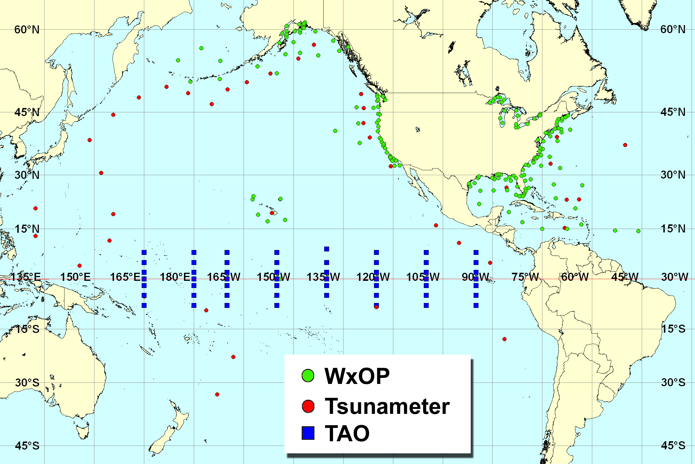
Figure 1 NDBC Buoy Locations
Many other organizations in U.S. and many countries also operate data buoys to provide vital environmental data for different applications, such as weather forecast, ocean prediction, ocean science, environmental protection, and search and rescue, to just mention a few. For example, Environment Canada operates 45 moored buoys (in the North Pacific, North Atlantic, Great Lakes, and other inland water), U.K. Met Office operates 11 Marine Buoys (in the Western North Atlantic, North Sea and Bay of Biscay), U.S. Gulf of Maine Ocean Observing System (GOMOOS) operates 7 moored buoys (in the Gulf of Maine), etc.
Data Buoy Vandalism
These data buoys, which are usually located in robust biotic ocean and marine areas, may experience damage from natural environmental factors (such as wind, waves, ocean currents, corrosion, fish bite, marine growth, etc.). In addition, they may be damaged accidentally or from unlawful interference in a deliberate manner. An unlawful interference with ocean data buoys (including willful or malicious destruction, defacement, or theft) is regarded as an act of vandalism. Buoy damage due to vandalism may occur by:
- Vessels collision causing buoy equipment and structural damage,
- Fishing vessel net or line entanglement and subsequent cutting of the mooring line to recover their fishing gear or free the vessel from the mooring,
- Fishing operations using the buoys as Fish Aggregating Devices (FADs),
- Theft of the buoy system or its equipment (e.g., sensors, solar panels, etc.), and
- Vessels tying up to the buoys as temporary anchors or safe havens.
Buoy vandalism has a significant financial impact to buoy operators, including cost of the damaged / lost equipment, ship time and labor cost for repairing, retrieval, and/or redeployment, and the cost of searching for adrift buoys. More importantly, vandalism disrupts the vital data collected and reported by the buoy systems, which place lives, property, and economies in peril. For example, data collected by NDBC buoys contribute to saving lives, making marine operations safer, aiding commerce and transportation, and protecting the environment. Impacts of buoy vandalism are extremely significant from financial, scientific, marine prediction and warning, and marine operations standpoints. For example, since the TAO buoys are critical in the monitoring and prediction of El Niño or La Niña phenomena, loss of TAO data will substantially impact climate prediction that affects important business variables like sales, revenues, and employment in a wide range of climate-sensitive industries and sectors, including commercial fishing. Damage to the WxOP and Tsunameter buoys due to vandalism results in the similar loss of critical information for weather and marine forecasts, at-sea rescue efforts from drift modeling, and most importantly, tsunami warnings an event that could result in significant loss of life and properties in coastal communities throughout the world.
As NDBC data buoys are located in U.S. coastal waters as well as in the open ocean, vandal activities occur to these buoys around the world (both inside and outside of U.S. EEZ). Vandalism has increased dramatically over the past few years and is causing significant problems to NDBC ocean observing buoy networks. For example, within the last five (5) years, NDBCs weather and ocean buoy program has seen fifty-four (54) documented cases. In 2008, there were 16 buoy failures due to vandalism (among a network of 109 buoys). At an average cost of $100,000 per event thats a cost of $5.4 Million to the taxpayer and an incalculable loss when factoring in the economic impact to the US economy due to erroneous and missed forecasting opportunities. Another example is that eighteen (18) TAO buoys in the Tropical Pacific Ocean went off-station due to vandalism between October 2007 and June 2008. Excluding ship cost, the financial cost to the U.S. Government (NOAA) for this vandalism is nearly $2 Million. In addition to the U.S. government resources loss, a rough order estimate is that vandalism contributes a continuous 15% to 20% impact to data availability and quality
Vandalism on NDBC Buoys
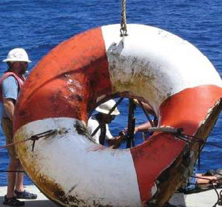
Figure 2. NDBC Weather buoy damaged due to ship collision
The damages or failures are usually caused by the following vandal actions on NDBC data buoys.
(1) Vessels colliding with buoys
When a vessel hits a buoy system, it could (i) damage the buoy hull so the buoy loses its buoyancy and sinks or (ii) damage the equipment or its supporting structure. Figure 2 shows the superstructure of a weather/ocean buoy (at station 42007) damaged due to a collision. Figure 3 shows a TAO buoy hull damage due to collision and Figure 4 shows a TAO buoy clearly damaged by a vessel collision.

Figures 3 and 4. NDBC Weather buoy (left) and TAO buoy (right) damage due to ship collision
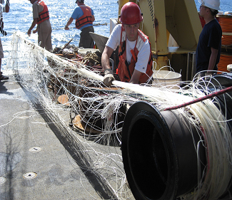
Figure 5 Fishing net recovered when retrieving a TAO buoy
(2) Fishing vessel nets or lines entanglement
When a fishing vessels fishing gear becomes caught or tangled with a buoys mooring system, the
vessel operators typically either cut the fishing gear or cut the mooring line. When the mooring is
cut, the buoy becomes adrift and data are lost or unusable. Even if the vessel operator is kind enough
to cut its own gear, the related action or a large amount of fishing gear left on the mooring line could
still damage the buoy/equipment (especially the underwater sensors) or degrade the data. Figure 5 shows
a large amount of fishing net recovered when retrieving the TAO buoy/mooring system. Figure 6 shows the
retrieved mooring line (nylon line) at a weather/ocean buoy (station 41040) was fouled with a long-line.
Figure 7 show a clear cut of the nylon line on a DART buoy.
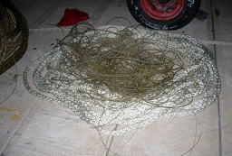
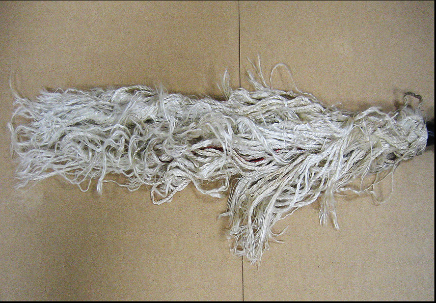
Figure 6 (left) Fishing line on the mooring from an NDBC Weather buoy. Figure 7 (right) Cut of a mooring line on a DART buoy
(3) Fish operations using the buoys as fish aggregating devices (FADs)
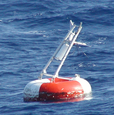
When fishing operations rely on buoys as FADs, the fishing vessels either tie off their own FADs to the buoys or tie their vessels off on the buoys and utilize a sling shot method to harvest a larger amount of fish. Figure 8 shows a FAD (lower left corner of the picture) tied to a TAO buoy.
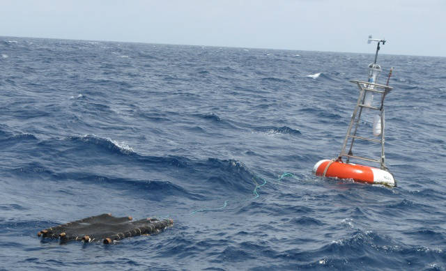
Figure 8 An FAD tied to a TAO buoy
The sling shot method is applied in the following steps: (1) a fishing vessel ties to the buoy; (2) the vessel moves away and stretches the mooring; (3) the vessel releases the buoy; (4) the buoy settles back over the anchor while the buoy is returning to the original position; and (5) the vessel sets nets to catch the fish following the buoys. NDBC frequently finds buoys with hawsers attached to the buoys, which is an indication of a sling shot. This method places a tremendous amount of stress on the buoy mooring line and anchor system. These actions will either damage instruments and equipment or rip the buoy from its mooring and make it go adrift. Through satellite tracking of buoy movement patterns, NDBC has sufficient data to conclude that the buoys are damaged after being used in this manner. Figure 9 shows a TAO buoy being repaired by a technician. The thick tug line on the buoy hull was not NDBCs line but was a line used by fishermen to apply the sling shot method. Figure 10 shows a similar case for a weather/ocean buoy. A technician was repairing sensors damaged by a vessel at buoy station 46006. The black line tied to the lower buoy structure (at the right side) was not NDBCs line and was a leave-over from a fishing or recreation vessel which make the damage to the sensors.
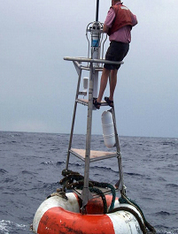
Figure 9 (left) A TAO buoy was used as a FAD (possibly a sling shot method).
Figure 10 (right) A Weather/Ocean buoy was used as an FAD.
(4) Theft of the buoy system or its equipment
Some vandals actually entered the buoy and stole some valuable sensors or equipment, such as solar panels (Figure 11).
Others even cut the mooring line and took an entire buoy with them. A recent case of buoy theft occurred at an NDBC TAO buoy resulting in the total loss of the asset. On May 1, 2009, the TAO mooring located at 8°N 95°W showed signs of vandalism evidenced by the simultaneous failure of all surface and subsurface instruments. Initial indications were that the buoy had been pulled from its anchor and was adrift (the equipments Argos transmitter was still working and was providing track information). By the next day it became obvious that the equipment was on a ship as it was traveling at a high rate of speed. It made landfall at Puntarenas, Costa Rica on May 14, 2009 shortly after midnight GMT. The position of the equipment was relayed to the Costa Rican Coast Guard via the U.S. State Department on May 14. On May 15, the Costa Rican Coast Guard searched the area for the missing equipment, but was unsuccessful. The equipment stopped transmitting its position later that day, indicating that it had been taken inside or concealed. Figure 12 shows a bare TAO buoy hull in a harbor in Costa Rica. The whole superstructure with sensors and electronic tube were removed and stolen.
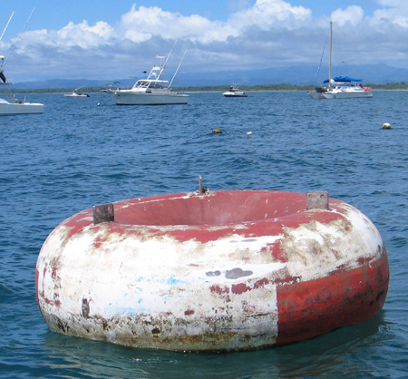
Figure 11 (left) Theft of sensors and solar panel from a Weather/Ocean buoy
Figure 12 (right) Stolen TAO buoy in Costa Rica
(5) Vessels tying up to data buoys
NDBC has received numerous reports from other passing-by vessels that some people tied up their vessels to NDBC buoys as temporary anchors or safe havens. Although they probably had no intention to harm the buoys/mooring by this kind of activities (which will probably not show immediate damage to the buoys), there are several possible problems: (1) affecting the accuracy of measured data, (2) gradually hurting or damaging the buoys (especially their moorings), (3) accidentally damaging the buoys and their moorings (e.g., damaging the sensors or solar panels).
Prevention of data buoy vandalism
Data buoy vandalism has been an insidious problem for a long time. In addition to the significant financial impact to the buoy operators, impact of loss of vital ocean and environmental data from data buoys due to vandalism is huge when considering the impact to the US economy and the realized or potential loss of lives and property. In addition, data buoy vandalism also occurs to any country in the world having moored data buoys. Therefore, preventing data buoy vandalism is not solely an effort by the U.S., but is rather an international effort. Preventions of data buoy vandalism can be categorized into three categories: technology, regulatory and statutory action, and education and outreach.
(1) Technology:
In the past few years, data buoy operators around the world, such as NDBC, tried using different buoy or mooring designs to reduce or prevent buoy vandalism. These design efforts included more robust mooring systems (e.g., using abrasion or cut resistant mooring components), shorter or no superstructures at all, protection to critical equipment (e.g., transmitter, antenna, etc.), designs to make it difficult to board a buoy, and newer equipment that was difficult to remove, etc. However, there is only so much buoy operators can do with technology without drastically increasing operating costs. Also, it is possible that vandalism preventive designs could make a buoy system more difficult to operate and maintain, or could adversely affect the quality of the collected data. Absent of these constraints, every data buoy operator would strive to make necessary buoy/mooring design modifications to address the vandal problems.
Recently, NDBC started an effort to study some non-lethal techniques to deter fishes or thefts. There are many possible non-lethal and animal-friendly techniques to deter fish from staying near mooring cables of a data buoy so the fishermen will not attempt to fish around the platform. One technique to deter on-board vandalism is to use sound or high-pitch noises to deter people from boarding a data buoy. Of course, it is expected that the devices for these techniques would be standalone so they will not affect normal data collection/reporting mission.
NDBC will continue to investigate the prospect of disestablishing or moving buoys from problematic locations. A recent example from the WxOP program illustrates how these moves can be undertaken. A buoy located 200 nm east of Cape May, NJ was relocated 120 nm to the Northwest to reduce the effects of constant vandalism and better serve the user community. Prior to the move several discussions with stakeholders were held and it was ultimately determined that all parties would be better served by repositioning the buoy. The drawback to relocating a buoys location is the loss of climatological measurements made at the station. NWS forecasters become dependent upon buoys being in a certain location because they can translate buoys measurements with future forecast tendencies. The loss of data at a certain location also disrupts climate records which are so important to understanding climate change.
(2) Regulatory and Statutory Action
For the U.S. domestic data buoys, some existing legal statutes can be used to deal with the buoy vandalism problem. For example, Title 33 of the Unites States Code (USC) contains two statutes that can be used to prevent data buoy vandalism and accidental damage (i.e., 33 USC §408 and §412) and several statutes under Title 18 of USC may apply to the damage of data buoys. Several Parts under Title 33 of Code of Federal Regulations (CFR) contain regulations aimed at protecting aids to navigation (which are maintained and regulated by the United State Coast Guard) and could be amended to expand their protections to include data buoys. In addition, many coastal and Great Lakes states have statutes that could be used to address data buoy vandalism in state waters. It is suggested to review existing legal statutes and initiate modified drafts to governing authorities, if needed.
NDBC has initiated and continues to pursue coastal buoys being classified as Aids to Navigation (ATON), which would have additional regulatory, statutory and subsequent enforcement benefits. For example, there is a provision within the ATON statutes that allows for the reporter or anyone giving information leading to the conviction of a party caught damaging, destroying, or defacing and ATON, to receive up to half of the $2,500 fine. In addition to the fine, a convicted party can receive up to 1 year imprisonment. Here there is monetary incentive that is not budgeted or does not come from the operators budget, but would be paid by the offending party. Again, it should be stressed that this is only an option for those buoys located within the boundaries of the U.S. Continental shelf. Currently, NDBCs USCG Liaison Officer has elevated the request to the USCG headquarter level and there has been preliminary legal review. However, until this is incorporated into the ATON regulatory body, the governing statutes, with respect to enforcement, are 18 USC Sec. 641 and Sec. 1361; Public money, property, or records, and Government property or contracts, respectively.
To address the international vandalism problem, NOAA Office of General Counsel recently submitted a draft resolution on data buoy vandalism to the IOC, which calls for action to the UN General Assembly in order to preserve the integrity of monitoring systems that are so essential to preserving life and property in coastal communities around the world. It has suggested to call upon [UN] Member States to take appropriate steps under their national law to prohibit damage of or interference with ocean and coastal observing systems, institute incentives to reward those who supply information that supports enforcement of such prohibitions, develop procedures to facilitate retrieval of non-functioning ocean and coastal observing systems, and educate local communities It also calls upon States and regional fisheries management organizations and arrangements, working in cooperation with other relevant organizations to adopt conservation measures to protect ocean and coastal observing systems by 2012 and report their action to the 67th session of the UN General Assembly.
Recently, the Western and Central Pacific Fisheries Commission (WCPFC) adopted the Conservation and Management Measure on Prohibiting Fishing On or Around Data Buoys (WCPFC CMM-2009-05) proposed by United States delegation led by NOAA Legal Office. The adopted measure states that includes Members of the Commission, including Cooperating Non-Members CCMs shall (1) prohibit their fishing vessels from fishing within one nautical mile of or interacting with a data buoy in the high seas of the Convention Area, (2) prohibit their fishing vessels from taking on board a data buoy, (3) encourage their fishing vessels operating in the Convention Area to keep watch for moored data buoys at sea and to take all reasonable measures to avoid fishing gear entanglement or directly interacting in any way with those data buoys, (4) require their fishing vessels that become entangled with a data buoy to remove the entangled fishing gear with as little damage to the data buoy as possible. The measure also states: Fishing activities inconsistent with paragraphs 1 and 2 above shall be deemed fishing activities that undermine the WCPF Convention and WCPFC conservation and management measures and shall constitute a serious violation in accordance with Article 25 of the Convention.
(3) Education and Outreach
Other than buoy and mooring design efforts, most of the efforts to prevent data buoy vandalism have been limited to education and outreach. Some countries reported that their outreach and education efforts were effective and significantly reduced buoy vandalism. Some countries and organizations thought education and outreach had limited impact on the overall problem because the underlying cause of buoy vandalism is economic in nature. It is more cost effective to the fisherman whose gear has become entangled in a buoy mooring to cut the buoy mooring than it is to cut or lose the fishing gear. It will be very useful and effective to use education and outreach activities to broadcast that more and stringent statutory and enforcement regulation (as discussed in the previous paragraph) are in place to discourage vandalism. NOAA also plans to establish reward or volunteer programs, such as an adopt-a-buoy program (similar to the adopt-a-highway program in U.S.) which encourages local marine groups or organizations to monitor buoys in their area. It is clear that education and outreach efforts have to be sustained over a long period of time to produce positive results.
U.S. and International Efforts on data buoy vandalism
NOAA, NDBC, countries participating in the Joint World Meteorological Organization (WMO) and Intergovernmental Oceanographic Commission (IOC) Technical Commission for Oceanography and Marine Meteorologys (JCOMM) Data Buoy Cooperation Panel (DBCP), and other buoy operators have recognized the vandalism problem for a long time. Recently, national and international efforts to address data buoy vandalism problem have been ramped up in an effort to gain regulatory and statutory aid through international coalition, such as the UN and WCPFC efforts just discussed in the previous section.
It will be helpful to assemble a task force to investigate a data buoy vandalism alleviation strategy. Recently, NOAA started to establish interagency working groups within U.S. with the U.S. Army Corps of Engineers, the U.S. Coast Guard, the U. S. Geological Survey, the U.S. Navy, the Environment Protection Agency, the National Park Service, and other interested parties. The agencies will likely be partitioned into domestic and international working groups. The DBCP has also been working with the WMO-IOC participants for years to highlight buoy vandalism problems. This year, the DBCP will draft a letter for the WMO-IOC that details specific issues and presents possible solutions to buoy vandalism.
It is clear that prevention of data buoy vandalism is a difficult task. It will require a vigorous and sustained effort. However, because of the vital data provided by the data buoys (which can save lives and properties), it is imperative that some immediate action be taken to reduce future losses.
Back to top