Tropical Atlantic and Tropical East Pacific Areas
September through December 2007
Robbie Berg and John Cangialosi,Tropical Analysis and Forecast Branch, National Hurricane Center,
Miami, Florida
Atlantic, Caribbean, and Gulf of Mexico
The fall and early winter season over the tropical and subtropical Atlantic Ocean consisted of a combination of frontal systems and subtropical storms which led to warnings issued by the Tropical Analysis and Forecast Branch (TAFB). Nine gale warnings were issued for the Atlantic basinfive for the open Atlantic and four for the Gulf of Mexico. One of the events reached storm force and was successfully forecasted by TAFB. One of the gale warnings issued for the Atlantic waters never materialized, and a couple other events were difficult to verify due to lack of observations.
Atlantic
With tropical cyclones being the primary aspect of warnings in September and most of October, the first non-tropical gale event did not occur until 29 Oct. This gale was actually the longest of the period and lasted just over 5 days. Besides the first event, all of the gales in the Atlantic occurred during the month of December. Table 1 shows the list of gale events over the tropical and subtropical Atlantic waters from September through December.
The late October and early November high wind event was one of the more difficult scenarios to forecast and clearly explain. The initial synoptic weather features consisted of a stalled frontal boundary over and off the coast of central Florida extending northeast into the open Atlantic and a strong 1038 hPa high pressure system over the Mid- Atlantic States. At this time, around 1200 UTC 29 Oct, all of the gale conditions were occurring north of the front. The situation became increasingly complex as Tropical Storm Noel, which became a category one hurricane on the Saffir- Simpson scale on 2 Nov, moved northward into the Bahamas. Noel then became the primary low pressure area with high pressure weakening a little over the Mid-Atlantic United States. Tropical storm and hurricane warnings were issued for the winds directly associated with the storms circulation, while gale warnings were posted elsewhere for the winds associated with the gradient between Noel and the high. Several ships, including the El Yunque (WGJT), Caribbean Princess (ZCDG8) , Horizon Producer (WJDJ), Seakeepers (KS004), Emerald Princess (ZCDP8), and Carnival Glory (3FPS9), reported winds in the 35 to 45 kts range during the 29 Oct through 03 Nov time frame. Figure 1 is the National Weather Service surface analysis over the southwest Atlantic from 1200 UTC 31 Oct, which shows several reports of winds to gale force. Figure 2 is a corresponding QuikSCAT pass at 1023 UTC 31 Oct that reveals the core of strong winds near Noel and a larger area of winds to gale force well away from the storm. Winds finally subsided below gale criteria in the TAFB Atlantic forecast area (south of 31°N) at 1800 UTC 3 Nov as Noel moved northeast of the region.
The next gale event was anticipated to clip the northern portion of the TAFB forecast area beginning at 0000 UTC 21 Nov associated with a large midlatitude low pressure system. However, warnings were correctly discontinued before this date since all of the gale force and higher winds remained north of 31N.
A surface trough that formed in the tropical central Atlantic was responsible for the next gale event, which occurred in early to mid December. The tight pressure gradient between the trough and moderate to strong subtropical ridging along 32N set up east to northeast winds to gale force both east and west of the boundary beginning at 1800 UTC 9 Dec. As this trough continued westward in a favorable atmospheric environment it transitioned into Subtropical Storm Olga at 0000 UTC Dec 11, when the gale warnings were replaced by tropical storm warnings.
A short-lived gale force wind event began on 1200 UTC 16 Dec in the northwest portion of the TAFB Atlantic area of responsibility. Southwesterly gale force winds occurred for about 18 hours ahead of a strong cold front located in the Gulf of Mexico. All ships reporting gale force winds were north of the TAFB/OPC forecast border along 31°N and QuikSCAT showed only marginal gales brushing the border.
Another gale event occurred in the central Atlantic beginning at 0600 UTC 23 Dec and ending on Christmas Day. A tight pressure gradient between the tail end of a slow moving frontal trough with a series of embedded waves of low pressure and a 1035 hPa high pressure area in the mid-latitudes produced northeast winds to gale force mainly to the west or northwest of the frontal waves. Ships CP Jalisco (ZCDJ7) reported 40 kts winds and Maersk Nevada (WMLG) observed 35 kts, verifying the gale. Ships Navion Gothenburg (C6VR4) and BATFR16 (ship name not known) both reported peak winds near 30 kts during the 54 hour event.
The last gale of 2007 was a significant and long lasting one. The forcing was a large meandering low pressure system in the eastern Atlantic in the vicinity of 25°N 35°W. This low nearly transitioned to a subtropical storm as it deepened to 1004 hPa on 31 Dec. Figure 3 is a Metosat-9 infrared satellite image of the storm with ASCAT scatterometer and JASON altimeter data overlaid from around 0000 UTC 31 Dec. This ASCAT pass and several other scatterometer passes from surrounding days revealed winds to 45 kts within the northwestern semicircle. The very fortunate JASON overpass indicated seas as high as 7.9 m (26 ft) and a 3.7 m (12 ft) sea radius of 300 nmi north of the low center. This event persisted into the New Year finally winding down on 2 Jan.
| Start | End | Length (hrs) |
|---|---|---|
| 29 Oct 1200 UTC | 03 Nov 1800 UTC | 126 |
| 21 Nov 0000 UTC | Did not verify | |
| 09 Dec 1800 UTC | 11 Dec 0000 UTC* | 30* |
| 16 Dec 1200 UTC | 17 Dec 0600 UTC | 18 |
| 23 Dec 0600 UTC | 25 Dec 1200 UTC | 54 |
| 28 Dec 1800 UTC | 02 Jan 0600 UTC | 108 |
Table 1. Gale warnings issued for the tropical and subtropical Atlantic Ocean between September and December 2007. Asterisk refers to gale event that transitioned to Subtropical Storm Olga.
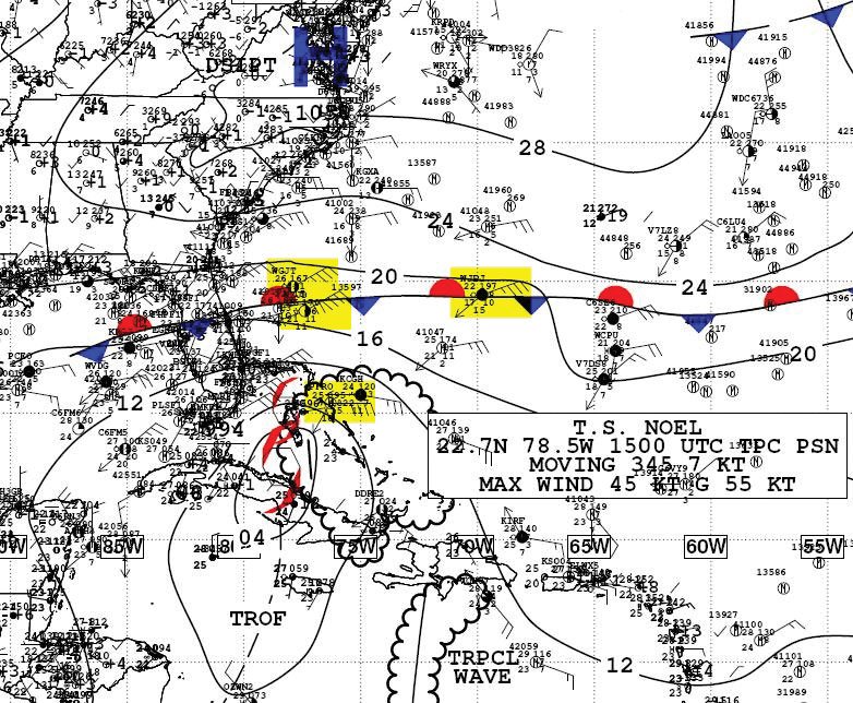
Figure 1. The 1200 UTC 31 Oct 2007
National Weather Service Unified Surface Analysis showing a tight pressure
gradient produced by Tropical Storm Noel, stationary frontal boundary, and
high pressure over the mid- Atlantic states responsible for producing a large
area of gale force winds. Ship observations showing winds to gale force are
highlighted in yellow.
(Click to enlarge)
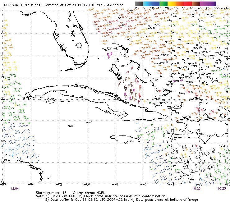
Figure 2. A QuikSCAT image from 1023 UTC
31 Oct 2007 showing tropical storm force winds near Noel and a large area of
winds to gale force well away from the storm center.
(Click to enlarge)
Gulf of Mexico
The first autumn wind event did not occur until late October, initiated by a potent early season cold front which moved off the Texas coast during the late morning hours of 22 Oct. See Table 2 for a complete list of gale and storm events. The first event turned out to be the strongest of the fall and early winter season. Northerly winds increased to gale force behind the front in the western Gulf by 1800 UTC 22 Oct as strong high pressure over the Southern Plains surged southward along the Mexican coast. These winds increased to storm force in the southwestern Gulf by 0600 UTC 23 Oct and persisted for 24 hours. Residual gale force winds continued for another 24 hours making this a two day warning event. The western Gulf NOAA buoy 42056 and a QuikSCAT pass on the morning of 23 Oct verified the gale and showed the storm event in the Bay of Campeche (Figure 4). The Deepwater Millennium (V7HD2) and Sealand Commitment (KRPB) reported sustained winds of 30 kts.
| Start | End | Length (hrs) |
|---|---|---|
| 22 Oct 1800 UTC | 24 Oct 1800 UTC | 48 (Gale) 24 (Storm) |
| 28 Oct 1200 UTC | 31 Oct 0600 UTC | 66 |
| 15 Dec 1800 UTC | 17 Dec 0000 UTC | 30 |
| 23 Dec 0600 UTC | 23 Dec 1800 UTC | 12 |
Table 2. Gale and Storm warnings issued for the Gulf of Mexico between September and December 2007.
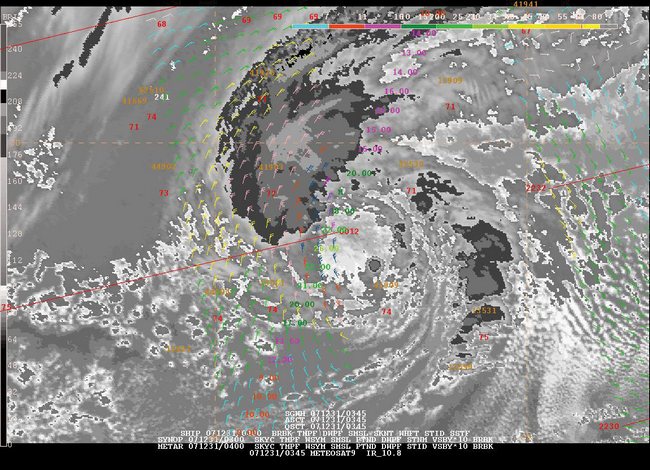
Figure 3. Metosat-9 infrared satellite image of a 1004 hPa low pressure system in the eastern Atlantic at 0345 UTC 31 Dec 2007. A 0012 UTC 31 Dec ASCAT pass is overlaid along with a JASON altimeter pass around 0000 UTC 31 Dec indicating winds to 45 KT and a maximum significant wave height of 7.9 m (26 ft).
Figure 4. A QuikSCAT image from 1148 UTC
23 Oct 2007 showing northerly gale force winds in the western Gulf with
evidence of storm conditions in the southern Bay of Campeche.
(Click to enlarge)
On a sad note, the strong winds and 7.6 m (25 ft.) seas led to a horrific marine accident in the Bay of Campeche around 2000 UTC Oct 23 when the mobile drilling rig Usumancita collided with the valve stem assembly of the Kab-101 light production platform. The collision caused a gas and oil leak, which prompted an evacuation of all 81 workers and 5 rescuers in life boats. At least 21 deaths where confirmed.
The next gale event occurred just four days later but was not purely of the same origin as the previous event. The combination of a nearly stationary low pressure trough in the northwestern Caribbean, a stalled frontal boundary over Florida and the southeast Gulf, strong high pressure surging southward along the Mexican coast, and to some degree Tropical Storm Noel well east of the area created a tight pressure gradient producing northerly gale force winds in the southwestern Gulf. Gale force winds began at 1200 UTC Oct 28 and persisted for 66 hours. Figure 5 is the National Weather Service surface analysis over the Gulf of Mexico and northwest Caribbean at 0000 UTC 29 Oct.
November and the first half of December were rather tranquil with no gale warnings issued. On 15 Dec, a cold front pushed off the Texas coast during the midday hours. Meanwhile a weak low, the remnants of Olga, was situated in the eastern Gulf. As the front tracked southeastward it absorbed the remnant low, enhancing the tight pressure gradient between the boundary and strong surging high pressure near the Mexican coast. Northerly winds increased to gale force behind the front in the western Gulf at 1800 UTC 15 Dec and ended 30 hours later. The warning was verified by west Gulf NOAA buoy 42002 and a high resolution QuikSCAT pass around 1200 UTC 16 Dec, which both revealed maximum northerly winds around 35 kts. Sustained winds of 30 kts were reported by oil rig Deepwater Horizon (V7HC9) and by ships Green Magic (C6VY5), and Horizon Challenger (WZJC) during the event. Another gale event occurred about a week later on 23 Dec behind a cold front. This wind event only lasted 12 hours as the fronts upper level support moved poleward leaving the boundary to weaken rather quickly.
Caribbean
Outside of the tropical cyclone activity, no warnings were issued for the Caribbean Sea during the September to December 2007 period.
Eastern North Pacific
With the exception of tropical cyclone activity, no warnings were issued for the Eastern North Pacific waters during the month of September. Much of October was also quiet until the notorious Southern California wildfire event began on the 20th.

Figure 5. The
0000 UTC 29 Oct 2007 National Weather Service Unified Surface Analysis showing
the synoptic surface pressure pattern that induced the longest gale event in
the Gulf of Mexico between September and December 2007.
(Click to enlarge)
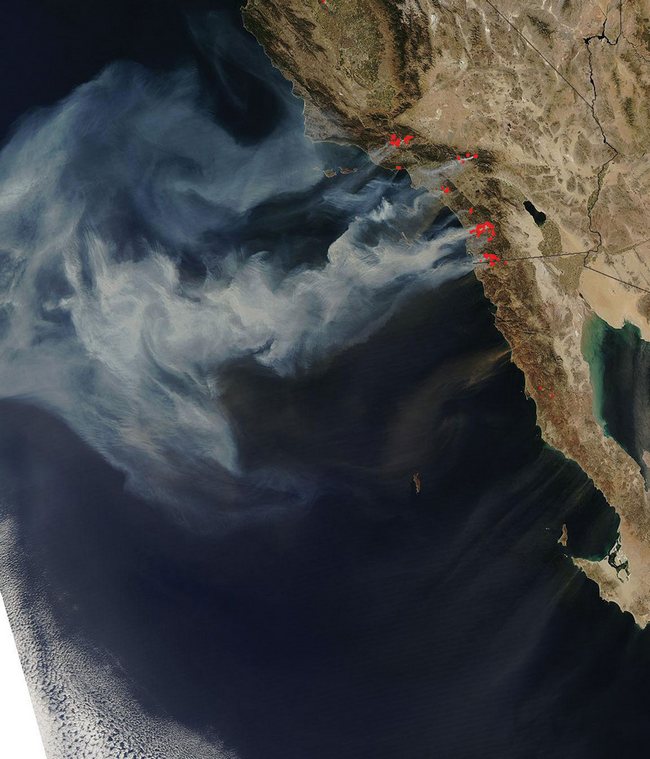
Figure 6. A NASA Terra satellite image of southern California and northwestern Mexico taken on 22 Oct 2007 showing active wildfires (red dots), smoke plumes (white), and dust plumes (faint brown streaks south of the smoke plumes) that spread over the adjacent Pacific waters during the significant Santa Ana event.
October Santa Ana Event
A frontal system moved from the Pacific Ocean eastward across southern California and northwestern Mexico on 20 Oct with strong high pressure building across much of the western United States during the following days. For about three days, a 1040 hPa high was anchored near the Great Salt Lake in Utah and the resulting pressure gradient, possibly exacerbated by a weakening Tropical Storm Kiko southwest of the Baja Peninsula, produced significant Santa Ana winds across southern California and northwestern Mexico. The extremely dry winds, which were gusting to hurricane force in some inland areas, also helped to trigger one of the most devastating wildfire events ever experienced across the region. Figure 6 shows an image of southern California and northern Baja California taken from the NASA Terra satellite on 22 Oct where the red dots indicate areas where an active fire was detected. The strong offshore winds blew a thick smoke plume westward over the adjacent Pacific waters, and widespread dust from the Sonoran Desert was driven southwestward across Baja California.
A QuikSCAT image (Figure 7) from the morning of 22 Oct shows some interesting wind-related aspects of this event over the tropical Pacific waters. This pass, along with a subsequent pass later that evening, indicated that the pressure gradient along the Gulf of California was strong enough to produce gale force conditions which began over northern parts of the gulf and then spread southward through the day. Although the Eastern Pacific high seas forecast produced by the Tropical Analysis and Forecast Branch (TAFB) indicated that winds would reach 30 kts within the Gulf of California about 24 to 48 hours before the event, a gale warning was never issued due to the inherent difficulty in anticipating these events. A similar event with explanation is noted in the December 2006 issue of the Mariners Weather Log. The image also shows three or four distinct low-level wind jets which extend southwestward away from the Baja Peninsula, occurring only downstream of gaps between the mountain ranges running along the spine of the peninsula. A calm region with winds less than 5 kts extends downstream from Picacho del Diablo (Peak of the Devil), the highest point in Baja California at 3095 m (10154 ft). Interestingly, winds rapidly increased to near gale force just a short distance south of the calm region. These small-scale events can pose a sudden danger to mariners traveling along the coast due to the large wind differences over small distances and the difficulty in providing such a forecast.
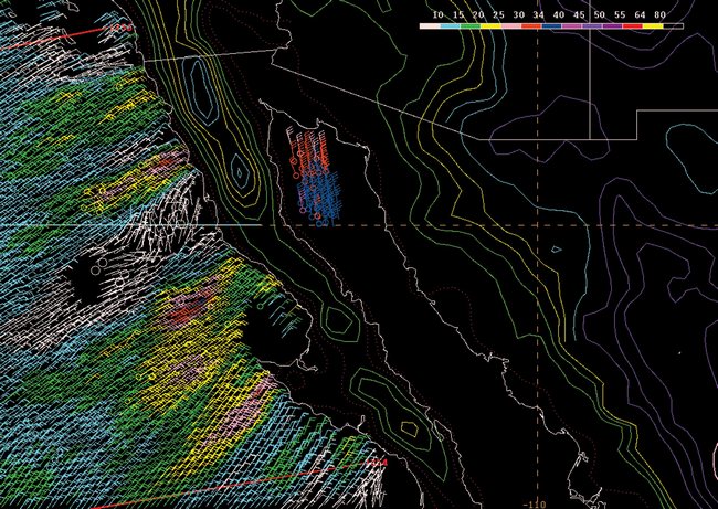
Figure 7. A QuikSCAT image from 1350 UTC 22 Oct 2007 showing gale force winds occurring over the Gulf of California and scattered low-level wind jets emanating southwest of the Baja Peninsula during the Oct 2007 Santa Ana wind and wildfire event. The colored lines over land give a relative sense of the topography, with blue and purple colors showing higher terrain.
Gulf of Tehuantepec Events
A total of seven Gulf of Tehuantepec gale or storm events occurred during the last four months of 2007. The first gale event of the cool season began at 1200 UTC 23 Oct, which is within the climatological mid- October timeframe for the first date of such an event. This event was driven by the same high pressure system that produced the Santa Ana event across southern California and northwestern Mexico as well as the storm event over the Bay of Campeche which caused the deadly Mexican oil rig accident (see Atlantic section for details). The TAFB high seas forecasts had a 36 hour lead time on the beginning of the event and noted a maximum of 45 kts occurring at 0000 UTC 24 Oct. However, this intensity may have been too low, and it is possible that a storm event had occurred according to a 12.5 km high resolution QuikSCAT pass from 0011 UTC 24 Oct (Figure 8) which showed several 50 kts wind barbs over the Gulf of Tehuantepec. The ship Lily Oldendorff (A8AY2) was extremely beneficial in providing ground truth observations during this event with several reports of high winds on 24 and 25 Oct. The highest wind reported by the ship was 50 kts at 0000 UTC 25 Oct with seas of 4.3 m (14 ft). The event ended at 0600 UTC 26 Oct and lasted for about 66 hours. A second gale event began just a little over a day later at 1800 UTC 27 Oct as reinforcing high pressure built southward over the Gulf of Mexico. Winds reached a maximum of 40 kts at 0600 UTC 29 Oct, and the event lasted for about 90 hours. One ship, the Hoechst Express (DHER), reported a maximum wind of 40 kts at 0600 UTC 30 Oct.
Three warning events occurred over the Gulf of Tehuantepec in November. The first was a fairly longlived gale event which lasted for nearly six days, beginning at 1200 UTC 3 Nov and ending at 0600 UTC 9 Nov. Maximum winds reached 40 to 45 kts on several occasions during the event although for a majority of the time winds were no higher than about 35 kts. Two ships reported 35 kts winds during the event: the Jacksonville (WNDG) at 0600 UTC 4 Nov and the Mol Expeditor (HPJW) at 1800 UTC 7 Nov. The second event resulted from a cold front which moved southward across the Gulf of Mexico and began at 1800 UTC 15 Nov. Winds reached a maximum of 45 kts at 0600 UTC 16 Nov, and the event lasted for 42 hours, ending at 1200 UTC 17 Nov. The Nikkei Tiger (3FMH7) was transiting across the gulf at 1200 UTC 16 Nov and reported winds of 35 kts. The third event lasted for only 24 hours between 1200 UTC 27 Nov and 1200 UTC 28 Nov, and winds only reached 35 kts. No ships reported gale force winds during this event.
Two additional Gulf of Tehuantepec gales occurred during December. The first event did not occur until the middle of the month at 1800 UTC 16 Dec, lasting for 48 hours. No ships reported gale force winds during the event, but a QuikSCAT pass from 0010 UTC 17 Dec indicated that winds were likely as high as 50 kts, only 5 kts higher than forecasted in the high seas forecast. The second event occurred about a week later at 1800 UTC 23 Dec and lasted for only 24 hours. Maximum winds are estimated to have been 40 kts although there were no ship observations of gale force winds at this time and there were no timely QuikSCAT passes. Although this was the last Tehuantepec warning event in 2007, the 31 Dec high seas forecast began advertising a significant warning event to begin just after the New Year with winds ultimately reaching hurricane force. This event will be described in the August 2008 edition of the Mariners Weather Log.
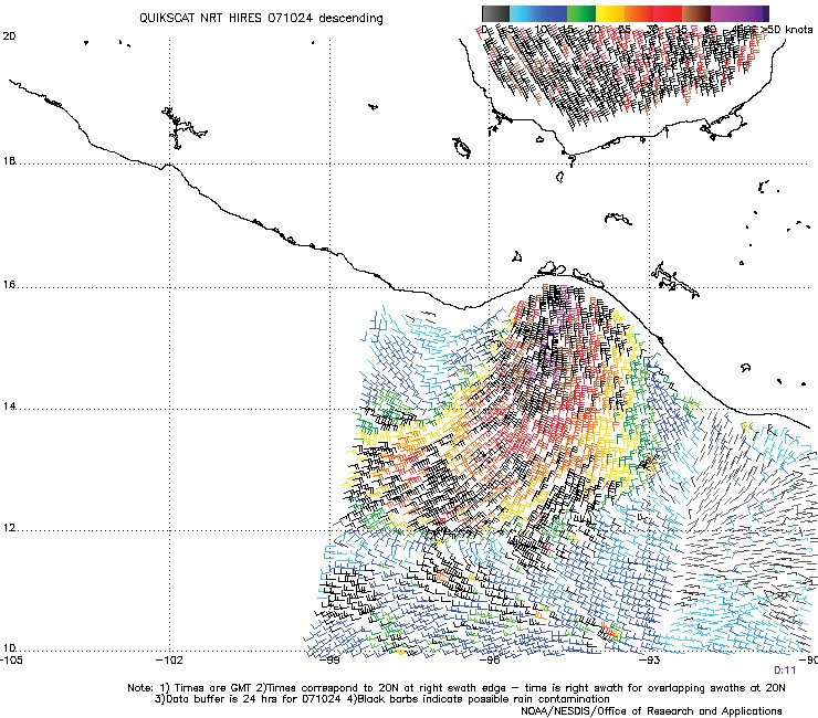
Figure 8. A 12.5 km high resolution
QuikSCAT image from 0011 UTC 24 Oct 2007 showing a storm event over the Gulf
of Tehuantepec with maximum winds near 50 kts.
(Click to enlarge)
Cold Front gale
A gale event occurred over the far northwestern part of the TAFB East Pacific area of responsibility from 1200 UTC 2 Dec through 1800 UTC 3 Dec due to a strong 952 hPa hurricane force low located northeast of the Hawaiian Islands and a trailing cold front which moved eastward across 140°W (Figure 9). The high seas forecast indicated southwesterly winds of 35 to 40 kts to occur ahead of the cold front and was verified by numerous 35 to 40 kts ship reports within and just north of the TAFB area of responsibility. The ships included the Zim Texas (ELTY6), the APL Sardonyx (9VVU), the Zim Savannah (A8ER9), the Zaandam (PDAN), and the Mokihana (WNRD).
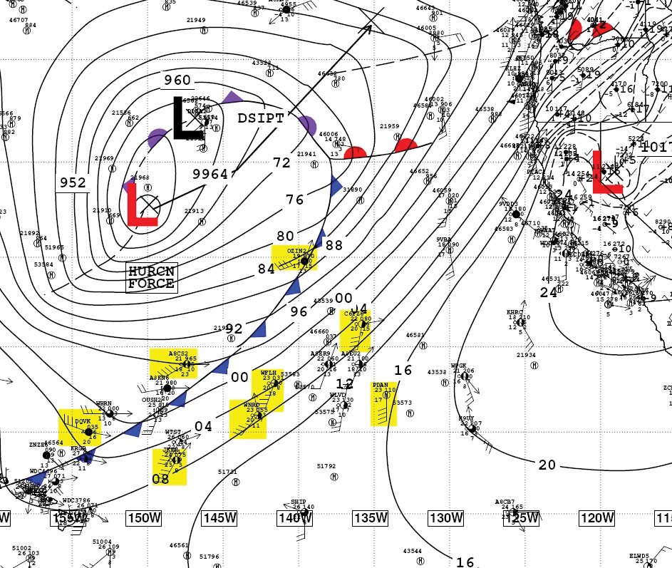
Figure 9. The 0000 UTC 3 Dec 2007
National Weather Service Unified Surface Analysis showing a 952 hPa hurricane
force low northeast of the Hawaiian Islands, responsible for producing gale
conditions across the TAFB Eastern Pacific waters. Ship observations showing
winds to gale force are highlighted in yellow
(Click to enlarge)
References
1. Bancroft, George, "Marine Weather Review, North Atlantic Area, September to December 2006", Mariners Weather Log April 2007.
2. Joe Sienkiewicz and Lee Chesneau, "Mariner’s Guide to the 500-Millibar Chart", Mariners Weather Log Winter 1995.
3. From Tropical Prediction Center website, http://www.nhc.noaa.gov/aboutsshs.shtml.
Back to top