Marine Weather Review Tropical Atlantic and Tropical East Pacific Areas - September through December 2002
Daniel P. Brown Tropical Analysis and Forecast Branch
Tropical Prediction Center, Miami, FL
Atlantic, Caribbean and Gulf of Mexico
It seems that the El Niño pattern that became established in the fall of 2002 was in part responsible for the development of low pressure centers over the southeastern United States or along the northern Gulf of Mexico. Two of these lows produced gale force winds over portions of the Gulf in November and early December. In late December, a strong cold front produced a prolonged period of gales over much of the subtropical Atlantic.
Gulf of Mexico and West Atlantic Cold Front 16-17 November: On 15 November, a cold front entered the northwestern Gulf of Mexico and moved slowly southeast. Early on the 16th, a low formed along the front over the north central Gulf and then moved northeast to the Florida panhandle. The pressure gradient tightened over the western Gulf as a strong high built southward behind the front. Northwesterly winds reached gale force shortly before 1200 UTC 16 November. At 1200 UTC, NOAA buoy 42002 near 25N 94W reported northwest winds of 36 kt. Sea heights at the buoy quickly rose to 4 m (13.5 ft). The P&O Nedlloyd Vera Cruz (PGFE) near 27.5N 94W encountered 35 kt winds at 1800 UTC. Along the Mexican coast, Veracruz observed sustained gale force winds for several hours. The sustained winds at Veracruz peaked at 60 kt with gusts to 80 kt, and the visibility dropped to 2 miles in blowing sand.
By 0600 UTC 17 November, the front extended from just east of Jacksonville, Florida to the Yucatan channel, while the high pressure was centered over southern Texas. At this time, winds began to decrease over the western Gulf of Mexico but remained above gale force over the central and east Gulf northwest of the front. Two ships, the Mormacsun (WMBK) and KMRH observed northerly winds of 35 kt along 26N between 87W and 90W. These observations verified the winds at NOAA buoy 42003 (26N 86W) which reported sustained winds of 35 kt with gusts to 45 kt between 0600 UTC and 1200 UTC. Sea heights at the buoy peaked at 4.3 m (14 ft). Over the western Atlantic, southwesterly winds increased to gale force north of 29N east of the front.
By 1200 UTC 17 November, the high pressure center moved into northern Mexico. This event also produced storm force (>48 kt) winds in the Gulf Tehuantepec (see Eastern North Pacific section below). Winds over the eastern Gulf of Mexico remained near gale force until 1800 UTC, then began to slowly decrease. However, over the western Atlantic, NOAA buoy 41010 (29N 78.5W) reported 36 kt winds with gusts to 46 kt and seas of 4.5 m (15 ft) just ahead of the front. Winds over the western Atlantic decreased below gale force by 0000 UTC 18 November.
Gulf of Mexico Cold Front 5-6 December: Shortly before 1800 UTC 4 December, a cold front moved off the Texas coast into the northwestern Gulf of Mexico. By 0600 UTC 5 December, the front extended from near Pensacola, Florida to the southwest Bay of Campeche. Strong high pressure centered over the southern Plains built southward behind the front. As this happened, northerly winds increased to gale force over the southwestern Gulf, mainly along the coast of Mexico. QuikSCAT data from 1235 UTC indicated 30 to 35 kt winds south of 25N west of 95W.
By 1200 UTC 6 December, the 1030 hPa high was centered over south Texas. A 1203 UTC QuikSCAT pass continued to reveal 30 to 35 kt winds over the southwest Bay of Campeche. Later on 6 December, the high began to move east-northeast across the southeastern United States. The pressure gradient relaxed, and winds decreased below gale force by 0000 UTC 7 December. This event also produced storm force winds in the Gulf of Tehuantepec (see Eastern North Pacific section).
Atlantic Cold Front 25-28 December: At 0000 UTC 25 December, a cold front approached the southeastern U.S. coast while a low pressure center intensified along the coast of the Carolinas. Ahead of the front, southwesterly gales occurred along the Georgia and north Florida coast. Buoy 41010 reported southwest winds of 31 kt with gusts to 40 kt at 1000 UTC. At 1200 UTC 25 December, the 994 hPa low pressure center was located along the North Carolina coast with the front trailing south through 31N 77W to just north of West Palm Beach, Florida. West of the front, the winds also increased to gale force, and the ship Naparima (3FMM6) near 31N 78W encountered westerly winds of 40 kt. Just east of the front, NOAA buoy 41002 (32N 75W) reported 39 kt winds with gusts to 46 kt at 1300 UTC. At 1800 UTC, the Argonaut (KFDV) observed west winds of 35 kt near 30N 78W. Sea heights at buoy 41002 peaked at 7 m (23 ft) at 1900 UTC. QuikSCAT data from 2259 UTC revealed an area of 30 to 35 kt winds north of 28N west of 65W.
At 0000 UTC 26 December, the low deepened into a 973 hPa storm center off the coast of New England. The front extended southward from the low through 31N 68W to central Cuba. By 1200 UTC 26 December, the low was producing hurricane force winds well north of the area while the trailing front extended through 31N 60W to east-central Cuba. Gale force winds continued north of 29N between 52W and 70W. At 0000 UTC 27 December, the front extended through 31N 53W to extreme eastern Cuba. Shortly thereafter, the ship Endeavor (WAUW), just east of the cold front, encountered southwest winds of 35 kt and seas of 6 m (19 ft) near 30N 51W. By 1200 UTC, winds decreased below gale force west of the front. However, the combination of the front and a strong high over the eastern Atlantic continued to produce southwesterly gale force winds north of 29N within 300 nmi east of the front. The ship Looiersgracht (PFPQ) confirmed the gale force winds as it observed 35 kt southwest winds near 31N 40W at 0000 UTC 28 December. By 1200 UTC, the weakening front extended along 31N 40W to the north coast of Hispaniola. At this time winds finally decreased below gale force.
Eastern North Pacific
Beginning in early November 2002, the Gulf of Tehuantepec produced a large number of gale and storm events. Table 1 is a list of the beginning and ending times of Gulf of Tehuantepec gale or storm events from November and December 2002.
| Event | Beginning | Ending |
| 1 | 0000 UTC 07 November | 1800 UTC 08 November |
| 2* | 0600 UTC 13 November | 1800 UTC 14 November |
| 3* | 0000 UTC 17 November | 0000 UTC 19 November |
| 4 | 0000 UTC 20 November | 0000 UTC 24 November |
| 5 | 0600 UTC 28 November | 1200 UTC 30 November |
| 6 | 0600 UTC 01 December | 1800 UTC 02 December |
| 7* | 0600 UTC 06 December | 1200 UTC 08 December |
| 8 | 0000 UTC 14 December | 1200 UTC 15 December |
| 9 | 1200 UTC 20 December | 1800 UTC 21 December |
| 10 | 0600 UTC 25 December | 1200 UTC 26 December |
| 11 | 0000 UTC 28 December | 0600 UTC 30 December |
Table 1. Gulf of Tehuantepec Gale and Storm Events November - December, 2002. Estimated beginning and ending times for Gulf of Tehuantepec gale and storm events from November to December 2002. Storm events are denoted with an asterisk (*)
The Tehuantepec events in the fall of 2002 were the result of low pressure systems that formed in the Gulf of Mexico or over the southeast United States. These lows drove several cold fronts well south. Following the fronts, strong high pressure centers moved into south Texas or northern Mexico. The resulting pressure gradient then produced gale or storm force winds over the Gulf of Tehuantepec. In November, five Tehuantepec events occurred, including one of the strongest events that has been captured in QuikSCAT data. Six additional events occurred in December, including one storm event early in the month. The Tehuantepec events were verified by either reliable ship observations or timely QuikSCAT data.
Gulf of Tehuantepec Storm: 17-19 November: This event began after a strong cold front moved across the Gulf of Mexico on the 16-17 November. The front produced gale force winds over the Gulf of Mexico (see Atlantic section). The wind event began around 0000 UTC 17 November, as northerly gale force winds reached the Gulf of Tehuantepec. QuikSCAT data from 0050 UTC 17 November confirmed the presence of gale force winds by detecting 35 to 45 kt in the Gulf of Tehuantepec. The ship DHOLN near 13.5N 95.5W observed 35 kt winds at 0600 UTC.
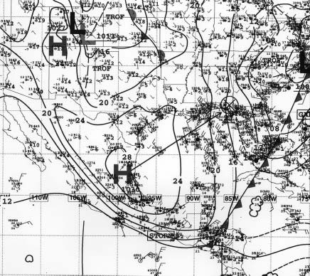
Preceding the event, the high pressure over the western plains was not as strong as in many other Tehuantepec events. However, during this event the high was driven unusually far south, down the coast of Mexico. At 1200 UTC 17 November, the high was centered near Tampico, Mexico with a pressure of 1030 hPa (Figure 1). By this time, winds reached storm force over the Gulf of Tehuantepec. A QuikSCAT pass from 1152 UTC indicated 50 to 55 kt winds, and satellite imagery from the same time detected a large arc cloud moving southwest-- away from the Gulf of Tehuantepec. The arc cloud defined the leading edge of the wind surge as seen in QuikSCAT data (Figure 2).
|
|
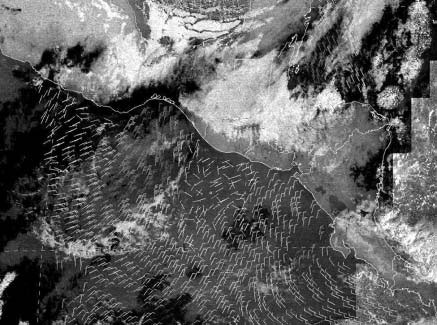
The subsequent QuikSCAT pass about 12 hours later continued to show a large area of storm force winds. The higher resolution QuikSCAT data from the 0024 UTC 18 November pass again detected a large area of 50 to 55 kt winds and a small area of 60 kt winds. These winds are possibly the strongest winds that QuikSCAT has detected in the Gulf of Tehuantepec since it began routinely providing ocean surface winds in the fall of 1999. Winds over the Gulf of Tehuantepec decreased below storm force by 1200 UTC 18 November. At that time the high pressure center had moved northeast and was centered over north Florida. Shortly after 1200 UTC, winds decreased below gale force in the Gulf. Overall, the event was well forecast by numerical forecast models and by forecasters at the Tropical Analysis and Forecast Branch (TAFB) of the TPC. TAFB issued a storm warning about 36 hours prior to the onset of storm force winds.
Additional Gulf of Tehuantepec Events: The first Tehuantepec gale event of the fall season began just before 0600 UTC 7 November. Later that day, a 2341 UTC QuikSCAT pass detected 40 kt winds in the Gulf of Tehuantepec. There were no ship observations of gale force winds during this event. However, the ship SeaLand Racer (V7AP8) located well south of the Tehuantepec observed 30 kt winds at 0000 UTC 8 November. The event ended around 1800 UTC 8 November.
The next event was the first storm event of the season. The event began around 0600 UTC 13 November. This event was verified by QuikSCAT data, as no ship observations of gale or storm force winds were available. QuikSCAT data detected gale to storm force winds of 40 to 50 kt at 0027 UTC 14 November. The event ended around 1800 UTC later that day.
The third event of the season was the very strong storm event summarized above.
The fourth event was rather prolonged, lasting four days. Gale force winds began at approximately 0000 UTC 20 November and ended around 0000 UTC 24 November. Several QuikSCAT passes denoted 35 to 40 kt winds during the event. At least one QuikSCAT pass revealed winds as high as 45 kt. The ship Christoforo Colombo (ICYS) encountered 40 kt winds at 1800 UTC 21 November.
The last event in November began 0600 UTC 28 November and ended 1200 UTC 30 November. During this event the ship P3JZZ observed 35 kt winds in the Gulf of Tehuantepec at 0600 UTC 29 November.
The first of six events in December began just before 0000 UTC 1 December. Two QuikSCAT passes between 0000 UTC and 1200 UTC 1 December detected 30 to 35 kt winds in the Gulf of Tehuantepec. The event ended about 1800 UTC 2 December.
The next event was the third storm event of the fall season. It began between 0000 and 0600 UTC 6 December. At 1200 UTC, the ship C6FD6 (name unknown) located just southeast of the Gulf of Tehuantepec observed 35 kt winds. QuikSCAT data from near that time revealed storm force winds over the Gulf. A subsequent QuikSCAT pass from 0035 UTC 7 December also detected 40 to 50 kt in the area. Later that night, the Royal Princess (GBRP) encountered 45 kt winds while crossing the Gulf of Tehuantepec. QuikSCAT data indicated that storm force winds ended by 1200 UTC 07 December; however, gale force winds continued until 1200 UTC 8 December.
The next three events where rather short-lived events each lasting between 24 and 36 hours. The first of these events began shortly before 0000 UTC 14 December and ended at 1200 UTC 15 December. During this event QuikSCAT detected 35 to 45 kt winds at 0055 UTC 14 December and 30 to 35 kt winds at 1157 UTC (later that day). QuikSCAT revealed that winds decreased below gale force by 1200 UTC 15 December. The next short-lived event began around 1200 UTC 20 December. A QuikSCAT pass from 1217 UTC 21 December indicated 30 to 35 kt winds in the area. The event ended around 1800 UTC 21 December. The next event began shortly after 0600 UTC 25 December. A QuikSCAT pass revealed gale force winds at 1214 UTC. QuikSCAT data from 0046 UTC 26 December also detected 35 to 40 kt winds. This short-lived event ended around 1200 UTC 26 December.
The last event of 2002 began around 0000 UTC 28 December. During this event, the ship Vega (9VJS) observed northerly winds of 25 kt about 240 nmi south-southwest of the Gulf of Tehuantepec; however, it is assumed that stronger gale force winds occurred over the Gulf of Tehuantepec. The event ended by 0600 UTC 30 December.
Page last modified: