MEAN CIRCULATION HIGHLIGHTS AND CLIMATE ANOMALIES
May through August 2004
A. James Wagner, Senior Forecaster, Climate Operations Branch, Climate Prediction
Center /NCEP/NWS/NOAA.
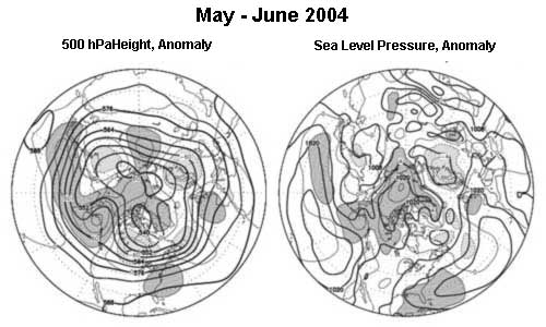
MAY - JUNE 2004
The circulation pattern over the Northern Hemisphere during May and June was characterized by generally above normal 500 hPa heights and sea level pressure over much of the Arctic Basin and across the North Pacific. A moderately amplified wave train prevailed from the East Coast of the U.S. across the Atlantic and most of Asia, with ridges over the Atlantic Coast of North America, the extreme eastern Atlantic Ocean, and central Russia, while troughs occupied the intervening positions. An extensive area of below normal 500 hPa heights covered much of Canada and the north-central U.S.
Although both months were unusually warm over Alaska, only May was mostly warm over the Lower 48 States with the exception of the northern border from Montana to upper Michigan. Convective activity and severe weather was frequent in the Midwest near the frontal boundary separating the cool and warm air. The ridge over Alaska moved somewhat further to the north in June, while the ridge over the southeastern U.S. weakened, allowing the downstream trough over the Lower 48 States to spread below normal temperatures to the south and east. An increase in convective activity from the southern Great Plains eastward across most of the South also contributed to the cooler conditions by lowering maximum temperatures due to increased cloudiness and wet ground.
Elsewhere, the ridge over the eastern Atlantic was related to an early summer heat wave over Spain, but the heat did not increase or persist throughout the summer in western Europe as it did the previous year.
Several typhoons were active in the southwestern part of the Pacific, where there were deep easterlies and relatively low westerly shear to the south of the subtropical ridge.
JULY - AUGUST 2004
During the high summer months of July and August, the abnormally strong ridge persisted over Alaska, leading to the warmest and one of the driest summers on record in many locations and contributing to a serious and prolonged outbreak of wildfires in the interior of the state. Relatively strong westerlies broke across the northern Pacific to the south of this ridge. A moderately amplified wave train prevailed from the Pacific Northwest across the Atlantic and most of Eurasia, with a ridge over the northern Great Basin and a broad and unusually strong trough centered over the Mississippi Valley.
Only the western part of the Lower 48 States was warmer than normal during July and August, while the area of below normal temperatures continued to expand and covered most areas east of the Continental Divide by late summer. The anomalous trough centered over the upper Mississippi Valley strengthened and expanded in area, pushing the remnants of the southeastern ridge out to the Canadian Maritimes. A relatively deep mean trough was located over the eastern Atlantic both at the surface and aloft, providing cool and somewhat wetter than normal weather. This was a welcome change from the previous summer's deadly record heat wave.
THE TROPICS
Recurrent Madden-Julian Oscillation (MJO) waves originating over the Indian Ocean triggered bursts of convective activity over that area and the western Pacific, setting off several Kelvin Waves in the equatorial Pacific Ocean. These eventually contributed to a gradual warming of the surface waters over the central Pacific so that by the end of August the criteria for the establishment of weak El Nino conditions had been met. Due to the seasonal cycle of temperatures over the eastern equatorial Pacific, the temperatures were not high enough to trigger anomalous convection often seen in stronger events. Throughout most of the summer, convection was concentrated along a pronounced ITCZ near 10N.
Several typhoons were active over the southwestern Pacific, where tropical cyclone development continued to be favored by deep easterlies. Most of the storms remained at low latitudes affecting the Philippines and China, but one struck Japan at the end of August.
The Atlantic hurricane season was a little slow to get underway, but it quickly became very active with seven named storms developing during August, in addition to the first one that formed at the end of July. Conditions were unusually favorable for tropical cyclogenesis in the Atlantic, where widespread areas of above normal sea surface temperature (SST) were located under regions of low westerly shear in the troposphere. The stronger than normal ridge over the Canadian Maritimes helped to steer many of these storms westward into the southeastern U.S., where an area of slightly below normal sea level pressure reflects this activity.
In contrast, tropical activity was less active than usual over the eastern Pacific, while the Summer Monsoon was active in Mexico but relatively weak and deflected east of the Continental Divide in the United States.
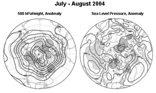
Figure legends and description of units:
The charts on the left shows the seasonal mean 500 hPa height contours at 60 m intervals in heavy solid lines, with alternate contours labeled in decameters (dm). Positive height anomalies are contoured in light solid lines at 30 m intervals, and light dashed lines show negative height anomalies. Areas of mean height anomalies more than 30 m above normal have heavy shading, and areas of mean height anomalies more than 30 m below normal have light shading.
The charts on the right show the seasonal mean sea level pressure (SLP) at 4 hPa intervals in heavy solid lines, labeled in hPa at selected intervals. Anomalies of SLP are contoured in light lines at 2 hPa intervals, with dark shading and solid lines in areas more than 2 hPa above normal, and light shading with dashed lines in areas greater than 2 hPa below normal.
Page last modified: