Hurricane Force Extratropical Cyclones Observed Using QuikSCAT Near Real Time Winds
Joan Von Ahn. STG/NESDIS ORA/NOAA Ocean Prediction Center, Joe Sienkiewicz, NOAA Ocean Predication Center, Greggory McFadden, SAIC/NOAA Ocean Prediction CenterHURRICANE FORCE (HF) winds (64 kts or greater) and the associated seas are a significant threat to safety at sea. These extreme cyclones are capable of producing loss of life and large loss of property. In 1998, losses of over 100 million dollars were reported when the containership APL China encountered HF conditions in the north Pacific from an extratropical cyclone that began as Typhoon Babs. HF cyclones can also impact coastal areas. A HF cyclone struck the southeast coast of England in October, 1987, and has since been referred to as the Great Storm. In December of 1999, a pair of HF cyclones (Lothar and Martin) hit northern France causing widespread tree damage and power outages. Although HF conditions are often thought to most frequently occur in tropical cyclones, forecasters and researchers at the National Oceanic and Atmospheric Administration (NOAA) Ocean Prediction Center (OPC) in Camp Springs, MD have been studying HF wind events associated with extratropical or mid-latitude storm systems using near-surface winds from the National Aeronautics and Space Administration (NASA) QuikSCAT scatterometer1. OPC forecasters routinely use QuikSCAT winds along with ship and buoy observations to determine wind warning categories of GALE (34 to 47 kts), STORM (48 to 63 kts), and HURRICANE FORCE (64 kts or greater). These warning categories are displayed on North Atlantic and North Pacific surface analyses that are broadcast via United States Coast Guard (USCG) Radiofacsimile and are also available via the Internet at http://www.opc.ncep.noaa.gov/. This article gives a brief summary of what the NOAA Ocean Prediction Center has learned about HF extratropical cyclones.
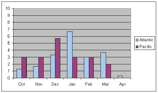
From October 2001 to April 2004 OPC forecasters observed a total of 120 HF cyclones (Table 1) in both the North Atlantic and North Pacific oceans (between 15 to 23 HF events each year per ocean). Cyclones were considered to be HF intensity if winds of 64 kts or greater were observed at any point in their life cycle by QuikSCAT, a ship of opportunity or a buoy. Only a handful of these cyclones began as tropical cyclones-the vast majority originated in the mid-latitudes. The monthly distribution of HF cyclone occurrences is shown in Figure 1. HF cyclones were observed in all months from October through April in both oceans with the highest frequency in the North Pacific in December and in the North Atlantic in January. Figure 2 shows the central pressure distribution of cyclones at HF intensity. The average central pressure at HF was between 965 and 970 hPa for both oceans. The distribution of pressure was found to be wider in the Atlantic (930 to 995 hPa) than in the Pacific (945 to 990 hPa). We observed that the Atlantic produced deeper HF cyclones (pressure wise) than the Pacific. We surmise that this is due to the higher baroclinicity (stronger temperature gradients) of the Atlantic compared to the Pacific. We also found that the Atlantic can produce weaker (pressure wise) HF storms than the Pacific. These are assumed to be due to the orographic influences of Greenland.
|
| |||||||||||||||||
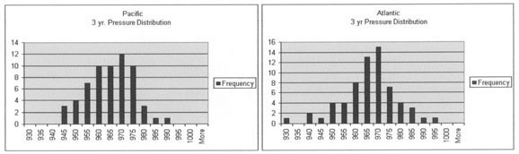 |
Figure 2. Frequency of HF storms versus minimum central pressure (hPa) for the Pacific (a) and Atlantic (b) from October to April of 2001 to 2004. |
For most cyclones, HF conditions were observed to occur at or near the time of minimum central pressure (the mature phase of the cyclone). We have found that HF conditions on average last less than 24 hours. This is relatively short-lived compared to the average life span of 5 days for ocean storms. Unfortunately this makes forecasting the timing of these extreme events difficult.

|
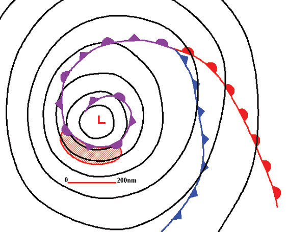
Figure 3. An alternative model of frontal-cyclone evolution (Shapiro and Keyser, 1990): incipient broad-baro-clinic phase (I), frontal fracture (II), bent back front and frontal T-bone (III), and warm core frontal seclusion (IV). Upper: sea level pressure (solid), fronts (bold), Figure and cloud signature (shaded). Lower: temperature (solid), and cold and warm air currents (solid and dashed arrows). (Adapted from Neiman and Shapiro, (3)) |
In tropical cyclones, HF winds tend to be found close to the center on the periphery of the eye wall. Where are HF conditions observed in mid-latitude cyclones? To answer this question, lets first take a look at the life cycle of a typical ocean storm. Figure 3 shows the evolution of an ocean storm as depicted by Shapiro and Keyser2 (1990). The cyclone begins as an open frontal wave with a warm front and cold front (I). As the cyclone intensifies, the frontal wave begins to amplify. The cold front pushes eastward (south of the low) and the temperature gradient tightens to the west of the low center (II). The front associated with this tightening temperature gradient west of the low is referred to as the bent back front or occluded front. The wave continues to amplify (III) as the bent back (occluded) front and associated temperature gradient swings eastward to the southwest of the low center. The strongest temperature gradient in phase III is associated with the continuous warm to bent back front and not in association with the cold front to the south. Phase III is referred to as the frontal T-bone. Phase IV shows the mature cyclone or warm core frontal seclusion. At this point the very strong temperature gradient (or front) has encircled the surface low center. A shallow pocket of relatively warm air has migrated to the low center and become cut off or secluded (thus the term warm seclusion). Within the warm seclusion the air is very unstable and convection may occur. An arc of very strong temperature gradient surrounds this pocket of warmer air with cold air found to the exterior of this temperature gradient. A very strong pressure gradient exists on the cold side of the temperature gradient (south of the low). It is in this area of strong pressure gradient that HF conditions are often observed.

|
Figure 4. Composite of maximum winds observed by QuikSCAT for open ocean HF cyclones for the months of October - April for the three year period from 2001 - 2003 in (a) the North Pacific (II cyclones) and (b) the North Atlantic (6 cyclones). Wind speed (kts) is shown in solid contours (color bar in center of figure.) In both (a) and (b) the area of HURRICANE FORCE winds is a red crescent shaped area to the south of the low center. |
To determine where HF conditions occur most frequently relative to the center of the mature cyclone, QuikSCAT winds were used to create composites of the maximum winds for 17 open ocean HF cyclones (11 in the North Pacific and 6 in the North Atlantic). These composites are shown in Figure 4. All cyclones used in these composites were near maturity or close to minimum central pressure. The Green shading depicts GALE FORCE winds, Yellow-STORM FORCE, and Red-HURRICANE FORCE. The occluded fronts are drawn in purple. Both composites show large crescent-shaped areas of HF winds to the south of the composite cyclone center. The Atlantic composite shows the band of extreme winds from 120 to 180 nmi from the center of the cyclone. The Pacific composite is slightly different with HF winds from approximately 60 to 150 nmi from the center of the cyclone composite. Is this the only location to expect HF winds? No! The cyclones used for these composites were chosen carefully to eliminate any possible land influence. QuikSCAT winds have also revealed HF conditions to the northeast of low centers in advance of (or north of) the accompanying occluded front and near mountainous coasts such as Greenland, Alaska, and the Kamchatka Peninsula.
Figure 5 is a conceptual model that shows the sea-level pressure, fronts, and area of HF winds of the mature phase of an ocean cyclone. The red-hatched area extending from southeast to nearly west of the low center illustrates where QuikSCAT frequently observes HF winds. Figure 5 illustrates where to anticipate HF winds in a mature cyclone. The QuikSCAT image from a mature North Atlantic cyclone from December 1, 2004 (Figure 6) reinforces this point. Note the large area of HF winds (RED wind barbs) to the south of the low center in agreement with the conceptual model in Figure 5.
|
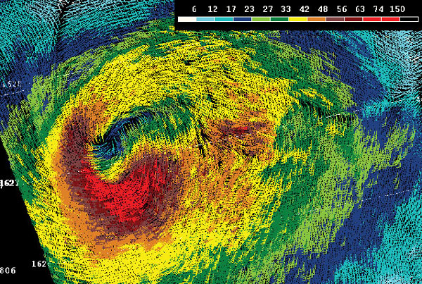
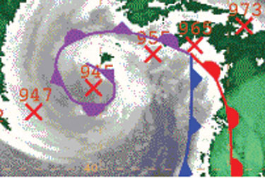
HF cyclones can indeed be very dangerous. A satellite image from October 26, 1998 from the North Pacific near the International Dateline is shown in Figure 7. The 6-hourly central pressures of this intense low from the OPC surface analyses are shown as red numbers (hPa). The low center locations are indicated by red-X's. This cyclone reached maturity with an impressive depth of 945 hPa. The occluded front and cloud head nearly encircled the low center similar to the mature cyclone (IV) shown by Shapiro and Keyser (Figure 3) and the conceptual model displayed in Figure 5. From Figure 5 one would anticipate that HF conditions would have been observed in a narrow band south of the low center and the occluded front. Indeed, that was where HF conditions were experienced by the container ship APL China. The APL China suffered one of the single largest losses of containers within hours of this image.
|
Figure 7. GOES 8 IR satellite image from 1800 UTC 26 October 1998 overlaid with the surface frontal analysis showing HF extratropical cyclone. Six hourly position (red X) and central pressure in hPa are shown. |
To summarize:
- HURRICANE FORCE winds do occur with mid-latitude winter storms
- The season extends from October through March for both the North Atlantic and Pacific
- HF cyclones occur most frequently in:
- December in the North Pacific
- January in the North Atlantic
- HURRICANE FORCE winds generally occur south of the low center on the cold side of the occluded front.
By continuing to study these extreme cyclones we hope to improve forecasts and provide mariners with adequate lead-time to avoid the dangerous conditions that occur during these events.
References
- Von Ahn, J.U. (2003). The Impact of QuikSCAT Winds on the Issuance of Marine Wind Warnings, Mariner's Weather Log, 47(2)
- Shapiro, M.A. and Keyser, D. (1990) .On the structure and dynamics of fronts, jet streams and the tropopause. Extratropical Cyclones: The Erik Palmén Memorial Volume, C. W. Newton and E. O. Holopainen, Eds., Amer. Meteor. Soc., pp.167-191.
- Neiman, P. J., and M. A. Shapiro, (1993). The Life Cycle of an Extratropical Marine Cyclone. Part I: Frontal-Cyclone Evolution and Thermodynamic Air-Sea Interaction. Mon.Wea. Rev., 121, 2153-2176.
Page last modified: