Tropical Atlantic and Tropical East Pacific Areas
September through December 2006
Dan Mundell and Hugh Cobb, Tropical Analysis and Forecast Branch, Tropical Prediction Center, Miami, Florida
Atlantic
The first non-tropical gale of the fall and winter season occurred in the Gulf of Mexico mid-October, which is typically the time when strong cold fronts begin reaching the area. The first non-tropical gale in the subtropical Atlantic was in late October. Nearly all of November was relatively quiet, except for a brief period of gale force winds on November 21 in the southern Caribbean Sea and near the Bahamas in the Atlantic.
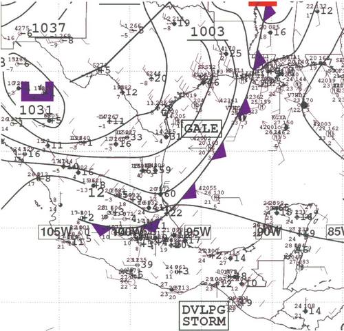
Figure 1. Tropical Prediction Center Surface Analysis valid at 0000 UTC 1 December 2006.
The most significant non-tropical wind event of the period occurred at the beginning of December in the western Gulf of Mexico. A strong cold front reached the Texas gulf coast at 1800 UTC 30 November, with gales developing behind the front as strong high pressure built southward west of 90W over the next 6-12 hours. Figure 1 is a surface analysis from 0000 UTC 1 December which shows a 1031 hPa high over northern Mexico and the cold front stretching across the Gulf of Mexico from southern Louisiana to just south of Tampico Mexico. Reports from NOAA buoy 42002 (25.2N 94.4W) during this period were of particular interest. At 2300 UTC the buoy reported 6 kts winds and 1.2 m (4 ft) seas ahead of the front, but within the next hour at map time northwest winds rapidly increased to 35 kts with the passage of the front. Five hours later at 0400 UTC sustained winds remained 33-35 kts gusting to 41-43 kts while seas increased rapidly to 5.5 m (18 ft). Over the next two days, the front became stationary over the central Gulf and winds decreased below 20 kts. Then another strong 1044 hPa high pushed southward into Texas and once again tightened the pressure gradient over the western Gulf. A QuikSCAT pass at 0118 UTC on 4 December (Figure 2) showed surface winds to 50 kts along the Mexico gulf coast, which prompted the National Weather Service to issue a storm warning west of 94W. The highest wind reported from this event was 40 kts with gusts to 50 kts from Coatzacoalcos Mexico (MMMT) at 1445 UTC 4 December. The 1200 UTC upper air sounding from Veracruz (MMVR) showed 50 kts winds just above the surface. Gales continued in the Bay of Campeche until 0000 UTC on 5 December.
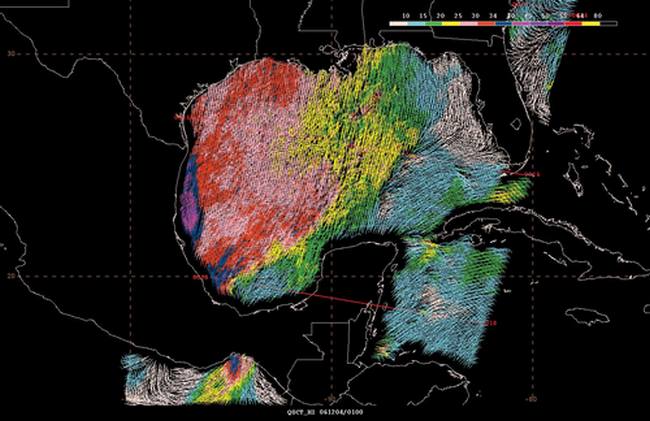
Figure 2. High resolution QuikSCAT image of satellite-derived winds for the Gulf of Mexico at 0118 UTC 4 Dec, showing an area of high winds between 34 and 50 kts near the coast of Mexico west of 96W.
Eastern Pacific
Gulf of Tehuantepec Gale and Storm events
The Gulf of Tehuantepec was quite active with a total of eight gale and storm events in the period from late October through December. Of these eight events, there were a record-tying six events classified as storm events based on high resolution (12.5 km) QuikSCAT data. The first event began around 1200 UTC 28 October, about a week after the climatologically average starting date for these events—21 October. The event lasted 48 hours and was accompanied by storm force winds as indicated by two successive QuikSCAT passes at 1222 UTC 28 October and 0053 UTC 29 October. Several ships reported gale force winds in association with this event with the strongest winds reported by the Newport Bay (MQEC7) at 1800 UTC on 28 October while located near 14N 94.5W within the belt of strongest winds. The ship indicated maximum winds out of the northeast at 43 kts with seas of 5.8 m (19 ft).
The next and weakest event of the season thus far began around 0000 UTC 3 November and also lasted 48 hours. A QuikSCAT pass at 0022 UTC 3 November indicated a modest gale with winds of 35 kts. However, the ship Merkur Sky (DDPH) reported 45 kts winds and 4.5 m (15 ft) seas at 0000 UTC 4 November while located near 14N 95.5W or about 90 nmi south-southwest of the Gulf of Tehuantepec.
The third event commenced two weeks later around 1200 UTC 16 November and was fairly brief, lasting only 30 hours. Despite the brief nature of this event, winds reached marginal storm force (48 kts) on the 0100 UTC 17 November QuikSCAT pass. There were no ships reports of gale force winds in this event.
The fourth event followed quickly on the heels of the most recent event and persisted for 108 hours from 1800 UTC 19 November to 0600 UTC 24 November, the longest lasting event thus far this season. This was also the strongest event of the season according to the 0030 UTC 22 November high resolution QuikSCAT pass which indicated hurricane force winds of 65 kts (Figure 3). In addition, this was the strongest Gulf of Tehuantepec event since the hurricane force wind event of 30-31 March 2003. The strong high pressure ridge (1035 hPa) associated with this event spread southward well into Central America and resulted in gale force winds in the Gulf of Papagayo as well (see section below). The extended duration of this event produced a wealth of gale and storm force ship reports in the area. The strongest wind report of 50 kts came from the ship Zim Japan (9HAC8) at 1200 UTC 22 November while the ship was located near 14.5N 95.5W. The ship also reported seas of 4.9 m (16 ft). Another noteworthy ship report included northeasterly winds of 40 kts from the Pacific Explorer (V7DN3) at 0600 UTC 21 November while the ship was near 11.3N 95.5W.
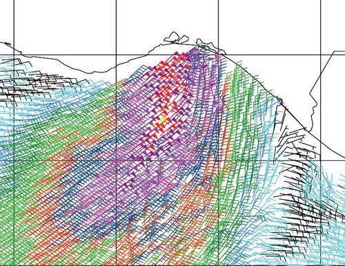
Figure 3. High resolution (12.5 km) QuikSCAT pass from 0030 UTC 22 November depicting swath of 55-60 kts winds in the Gulf of Tehuantepec with an isolated area of hurricane force winds denoted by the yellow barb.
The fifth event commenced around 1200 UTC 1 December and persisted for just under 42 hours. This was the same event which produced storm force winds over the Gulf of Mexico and was only the second of two gale events occurring in this period. Peak winds indicated by QuikSCAT were around 40 kts on two passes at 1242 UTC 1 December and 1220 UTC 2 December. The only report of gale force winds (north-northwest 35 kts) came from the Maersk Guernsey (MLYC8) at 0000 UTC 3 December while the it was located near 14.5N 97W.
The next event began at 0000 UTC 4 December and lasted 66 hours. Boundary layer wind forecasts from the Global Forecast System (GFS) model suggested winds may reach hurricane force even at the 10 m level. Consequently a hurricane force wind warning was issued at 1200 UTC 4 December.
This was another storm event as indicated by 50-55 kts winds on the 1238 UTC 5 December QuikSCAT pass. The existence of storm force winds was also verified by the ship Seabulk America (WWYY) which reported 52 kts winds and 9 m (30 ft) seas while traversing 200 nmi southwest of the Gulf of Tehuantepec near 13.3N 97.0W. Two hours later the same ship reported lower winds of 44 kts while located 40 nmi northwest of the previous position near 13.6N 97.2W thus indicating the ship had passed through the core of the strongest winds of this Tehuantepec event.
The seventh event began around 0000 UTC 8 December and persisted for more than 72 hours and attained storm strength. The 0104 UTC 10 December QuikSCAT pass indicated 50 kts winds. The third report of storm force winds for the season occurred at 0600 UTC 9 December when the ship Leverkusen Express (DEHY) reported 49 kts winds while located near 14N 95.9W.
The eighth event in this period commenced around 0600 UTC 26 December and lasted only 36 hours. More than two weeks elapsed since the previous wind event and sea surface temperatures recovered markedly in the Gulf of Tehuantepec between 10 and 25 December 2006 (Figures 4 and 5). The warm sea surface temperatures were a significant factor in mixing down stronger winds at higher elevations down to the surface. The 10 m wind fields from the GFS significantly under-forecasted this event with 10 m winds forecast to be in the 35-40 kts range verifying at 1200 UTC 26 December. The 1154 UTC 26 December QuikSCAT pass indicated that the second strongest event of the season had occurred with the high resolution data indicating winds of 55-60 kts. There were only a few ship reports of gale force winds associated with this event. Most of the ships were well away from the strongest wind swath in the Gulf of Tehuantepec. One of the few ship reports from near the area came from the ship Dirch Maersk (OXQP2) at 0000 UTC 27 December while located near 12.5N 94W. The ship reported peak winds out of the north-northeast at 37 kts with 4.9 m (16 ft) seas.
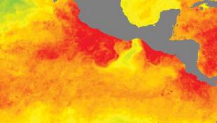
Figure 4. Combined Microwave and Infrared 25 km resolution SST image from 10 December 2006 shortly after the end of the 8-10 December gale event. The yellow-green swath in the Gulf of Tehuantepec indicates SST's had cooled to 21-22C
Image courtesy of Remote Sensing Systems
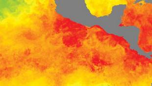
Figure 5. Combined Microwave and Infrared 25 km resolution SST image from 25 December 2006 prior to the beginning of the 26-28 December event. The orange-red areas in the Gulf of Tehuantepec indicate SSTs have recovered to 28-29C. Image courtesy of Remote Sensing Systems.
Gulf of Papagayo 22-23 November 2006
Strong high pressure (1035 hPa) over eastern Mexico surged southward well into Central America on 22 November and produced rare gale force winds in the Gulf of Papagayo.
An 1133 UTC 22 November QuikSCAT pass indicated gale force winds in the region and a gale warning was issued at 1630 UTC 22 November. The gale warning was in effect for 24 hours. The issuance of a gale warning was also supported by a report of east-northeast winds of 35 kts and 4 m (13 ft) seas at 1200 UTC 22 November from the ship Pacific Explorer (V7DN3) while located near 9N88W or about 150 nmi southwest of the Gulf of Papagayo. Another noteworthy ship report came from the vessel Merkur Sky (DDPH) at 1800 UTC 22 November while located further west near 9.5N91W. The vessel noted east winds of 34 kts and 4 m (13 ft) seas.