Nowcasting the Wind Speed During a Hurricane at Sea
Professor S. A. Hsu, Louisiana State UniversityNowcasting is a description of current weather and a short-term forecast varying from minutes to a few hours (see Greer, 1996). During a hurricane, nowcasting is needed to supplement the "official" forecast by the National Weather Service to steer the ship away from the danger imposed by the storm. Nowcasting of the wind speed is a way to avoid the danger. The methodology is as follows.
According to Anthes (1982, p. 22 and Fig. 2.8),
 (1)
(1)
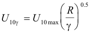
where ![]() is the sustained wind speed at 10 m at a distance away from the storm center, and
U10max is the maximum sustained wind speed at 10 m at the
radius of maximum wind, R.
is the sustained wind speed at 10 m at a distance away from the storm center, and
U10max is the maximum sustained wind speed at 10 m at the
radius of maximum wind, R.
According to Hsu et al. (2000), for operational applications,
 (2)
(2)
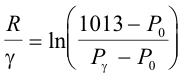
where P0 is the minimal sea-level or central
pressure of the hurricane, P![]() is the pressure at a point located
at a distance from the storm center, and ln is the natural logarithm.
is the pressure at a point located
at a distance from the storm center, and ln is the natural logarithm.
Substituting Equation (2) into (1), we have
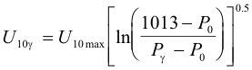 (3)
(3)
According to Hsu (2003, this issue),
![]() (4)
(4)
Therefore, U10![]() can be nowcasted by Equations
(3) and (4) using only a scientific calculator.
can be nowcasted by Equations
(3) and (4) using only a scientific calculator.
A verification of the above method is provided in
Figure 1. During Hurricane Lili in 2002, the National Data Buoy
Center (NDBC) had two buoys, #42001 located near R, and #42003 located due east along 26°N,
approximately 280 km from 42001. The wind speed measurement was 10 m for both buoys. From the National
Data Buoy Center (NDBC) Web site (http://www.ndbc.noaa.gov/) we have at 20Z 2 October 2002
at #42001, P0 = 956.1 mb. Substituting this
P0 into Equation (4),
U10 max = 47.5 m/s, it is
in excellent agreement with the measured value of 47.2 m/s. Therefore,
Equation (4) is further verified. At the same time, P![]() = 1011.1 mb
was measured at #42003. Substituting this P
= 1011.1 mb
was measured at #42003. Substituting this P![]() into Equation (3), we
obtain
into Equation (3), we
obtain
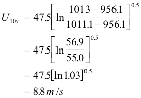
The measured U10![]() at 42003 was 9.2
m/s. Since the difference between 8.8 and 9.2 is (9.2 - 8.8)/9.2
or approximately 4%, we conclude that Equations (3) and (4) can be used for nowcasting
using the shipboard pressure measurement and P0
which is available via official "Advisory" during a hurricane.
at 42003 was 9.2
m/s. Since the difference between 8.8 and 9.2 is (9.2 - 8.8)/9.2
or approximately 4%, we conclude that Equations (3) and (4) can be used for nowcasting
using the shipboard pressure measurement and P0
which is available via official "Advisory" during a hurricane.
References
Anthes, R. A., Tropical Cyclones, Their Evolution, Structure and Effects (American Meteorological Society, Boston, MA, Meteorological Monographs Number 41, 1982, 208 pp).
Geer, I. W. (Editor), Glossary of Weather and Climate (American Meteorological Society, Boston, MA, 1996, 272 pp).
Hsu, S. A., M. F. Martin, Jr., and B. W. Blanchard, An evaluation of the USACE's deepwater wave prediction techniques under hurricane conditions during Hurricane Georges in 1998 (Journal of Coastal Research, 2000, 16(3), 823-829).
Hsu, S. A., Estimating hurricane induced maximum sustained wind speed at 10 m from its central pressure at sea.
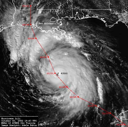 |
Figure 1. Satellite data (visible channel from NOAA-16) received and processed at the Earth Scan Lab, Louisiana State University, during Hurricane Lili (2002) in the Gulf of Mexico. The solid line represents the storm track. Data from NDBC buoys 42001 and 42003 are employed in this study. |
| (Return to Text) |
Page last modified: