Mean Circulation Highlights and Climate Anomalies
May through August 2008
Anthony Artusa, Meteorologist, Climate Operations Branch,
Climate Prediction Center NCEP/NWS/NOAA
May-June 2008
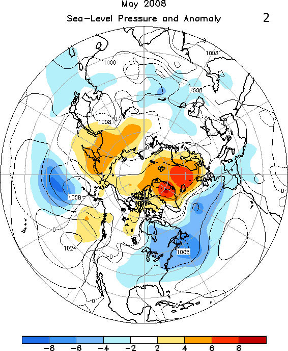
The circulation pattern over the Northern Hemisphere during May was characterized by above-normal mid-tropospheric heights across much of the eastern Pacific, northeastern Asia and from Baffin Island, Canada across Greenland and Iceland to northern Europe (Figure 1). In contrast, below normal mid-tropospheric heights were observed over the central Pacific, and from south-central Canada southeastward across the Great Lakes and Northeast US. Sea level pressure (SLP) was lower than average for the month from the northeastern US and southeastern Canada eastward across the North Atlantic to Spain, and also over the central Pacific. Above average SLP was observed over northeastern Asia and across Greenland, Iceland and much of Scandinavia (Figure 2).
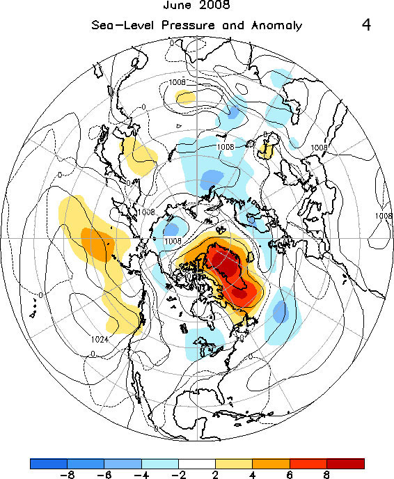
During June, 500 hPa heights were slightly below normal over much of the Northern Hemispheric circumpolar region between 50N and 70N, while above normal heights were observed primarily over the Greenland/Davis Strait area, portions of east Asia, and also over the western Aleutians (Figure 3). SLP anomalies during June were small over most of the Northern Hemisphere as is typical with the onset of summer, with the exception of the Greenland/Davis Strait area where SLP anomalies of +6 hPa or more were noted (Figure 4).
The Tropics
Negative sea surface temperature (SST) anomalies weakened in the central and east-central equatorial Pacific, while positive SST anomalies were confined to parts of the eastern Pacific during May 2008. The weekly Nino 3.4 index was -0.6C (the Nino 3.4 region is defined as 5S to 5N, and 170W to 120W). The 2008 hurricane season began in late May in both the Atlantic (Tropical Storm Arthur) and the east Pacific (Tropical Storm Alma).
In June, a transition from La Nina to ENSO-neutral conditions occurred, as SSTs returned to near-average across the east-central equatorial Pacific. Consistent with this pattern, the monthly SST index was -0.3C in the Nino 3.4 region. In the east Pacific, Tropical Storm Boris formed over the warm waters south of the Baja Peninsula.
July-August 2008
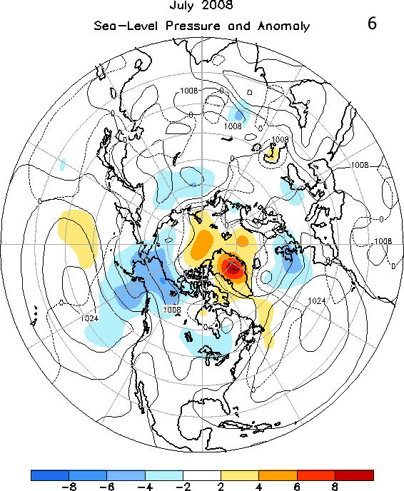
The mean circulation for July depicts above-normal 500 hPa heights across the eastern coast of Canada and much of Greenland, as well as the Kamchatka Peninsula and adjacent portions of the northwest Pacific (Figure 5). Heights were below-average across Alaska, the British Isles and north-central portions of Russia. The SLP map shows negative anomalies of at least -4 to -6 hPa over Alaska, and also the British Isles (Figure 6).
In August, well below-normal 500-hPa heights were observed over southern Alaska and the adjacent Gulf region in conjunction with a deep mean trough, while below normal heights were also observed over northern Europe (Figure 7). Above average 500 hPa heights were noted from eastern Siberia northward across much of the Arctic Ocean to Baffin Island, Canada. In general, sea level pressure in August was consistent with the mean circulation pattern, with well below average SLP observed over the Gulf of Alaska and southern Alaska, western Canada, northern Europe, and much of northern Russia (Figure 8).
The Tropics
In July, ENSO-neutral conditions continued across the tropical Pacific. The monthly SST index in the Nino 3.4 region advanced into positive territory (+0.1C). In the Atlantic, Bertha, at one time a major hurricane but later downgraded to a tropical storm, brought rain and wind to Bermuda on July 14th. Cristobal and Dolly were the other two named cyclones in the Atlantic basin in July, with Dolly becoming a Category 2 hurricane with 100 mph winds as it made landfall on South Padre Island, Texas, resulting in significant damage. The east Pacific was very active in July with the formation of Hurricanes Elida, Fausto and Genevieve.
In August, ENSO-neutral conditions persisted as SSTs in the central Pacific remained near average. The monthly SST index was +0.2C in the Nino 3.4 region. However, as is often the case with La Nina transitions to ENSO-neutral events, the atmospheric circulation continued to reflect lingering aspects of La Nina, as evidenced by enhanced low level easterly winds and upper level westerly winds over the western and central tropical Pacific, as well as suppressed convection near the Date Line (not shown). Atlantic basin tropical activity picked up sharply in August, with Tropical Storms Edouard and Fay, and Hurricane Gustav. Fay became the first storm in recorded history to make landfall in Florida four times, resulting in severe flooding, while Gustav brought significant loss of life and property damage to the Greater Antilles before making landfall in Louisiana.
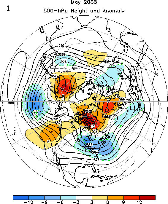
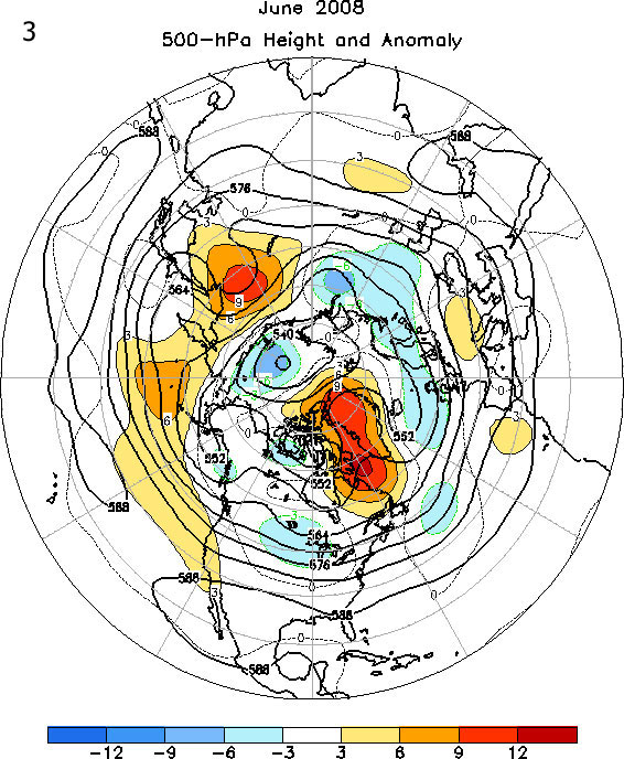
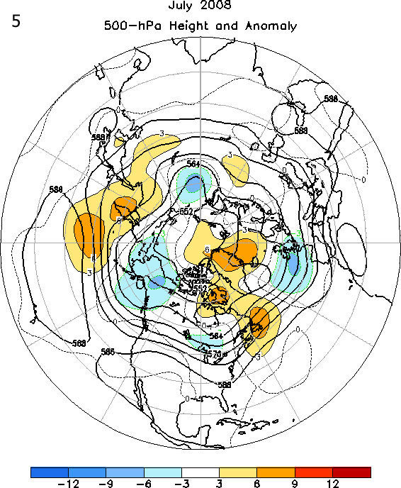


500 hPa Heights and Anomalies: Figures 1,3,5,7
Northern Hemisphere mean and anomalous 500-hPa geopotential height (CDAS/Reanalysis). Mean heights are denoted by solid contours drawn at an interval of 6 dam. Anomaly contour interval is indicated by shading. Anomalies are calculated as departures from the 1979-1995 base period monthly means.
Sea-Level Pressure and Anomaly: Figures 2,4,6,8
Northern Hemisphere mean and anomalous sea level pressure (CDAS/Reanalysis). Mean values are denoted by solid contours drawn at an interval of 4 hPa. Anomaly contour interval is indicated by shading. Anomalies are calculated as departures from the 1979-1995 base period monthly means.