Mean Circulation Highlights and Climate Anomalies
May through August 2006
A. James Wagner, Senior Forecaster, Climate Operations Branch, Climate Prediction Center /NCEP/NWS/NOAA.
May-June 2006
The circulation pattern over the Northern Hemisphere during May and June was characterized by generally above normal middle tropospheric heights over the western U.S. and most of Canada, surrounding an amplified trough that extended from the Great Lakes southward along the East Coast. Above normal heights and a stronger than normal surface high pressure ridge were also observed over southwestern Europe and the western Mediterranean. Above normal 500 hPa heights and sea level pressure were found over the northwestern Pacific, including the Bering Sea and Aleutians, while a stronger than normal middle tropospheric low prevailed over much of the Arctic Ocean, with a trough extension southward to Iceland.
The pattern over North America was more blocked in May, with well above normal heights over northeastern Canada and a rather strong trough near the East Coast. During June, heights over high latitudes, including northeastern Canada, were below normal, while strong ridges developed over the Rockies and Great Plains of North America, as well as over the Canadian Maritimes. Temperatures rapidly rose to well above normal over the West and the Great Plains, with some near record values observed in areas where long-standing dyrness over parts of the Great Plains also augmented the heat. The eastern U.S. remained cool, and periods of unusually wet weather affected parts of New England and the Middle Atlantic States, producing severe flooding in some areas. The strengthening ridge over the West set the stage for a bad summer wildfire season, following a generally good winter and early spring rainy season that had eliminated much of the long-term drought that had plagued the area the past several years. In contrast, severe drought and numerous wildfires continued in the Southwest.
July-August 2006
During the high summer months of July and August, middle tropospheric heights and surface pressures were generally lower than normal over the Arctic Basin and a deeper than normal trough prevailed over Alaska most of the time, in sharp contrast to the patterns that had prevailed in those regions during the previous two summers. These high latitude circulation anomalies were particularly strong in August. The result was a relatively benign season for wildfires in Alaska in 2006 due to prevailing cool and wet conditions. Above normal middle tropospheric heights continued over the northwestern Pacific from the previous two months, and they were also above normal from Greenland across the north Atlantic to Scandinavia. Heights were below normal over central and southern Europe, especially during August. A third area of above normal 500 hPa heights extended from the Pacific Northwest coast eastward to the upper Mississippi Valley near the U.S.-Canadian border, while immediately downstream a slightly stronger than normal trough prevailed over the Canadian Maritimes.
Both July and August were predominantly warmer than normal months over the lower 48 States, with the most excessive heat being located in the Great Plains and Rockies in July and generally over the eastern half of the country during August. The heat was exacerbated by severe drought in much of the Great Plains, and temperatures in Wyoming and the Dakotas rose to levels not seen since the Dust Bowl in the 1930s. The ridge over the Rockies was particularly strong during July, but a weak trough developed near the West Coast during August leading to more seasonable temperatures. As is often the case when the western ridge is anomalously strong and centered north of its normal summer position, the Southwest Monsoon was unusually active and much of Arizona, New Mexico, and west Texas was much wetter than normal, and flooding occurred in some locations that had gone for several months from last fall through late spring with no significant precipitation.
The Tropics
The status of the El Nino—Southern Oscillation (ENSO) phenomenon remained in neutral territory throughout the late spring and summer months, but it was undergoing a gradual transition from the weak La Nina that had prevailed during the previous winter and early spring to the onset of weak El Nino conditions in early September. Madden-Julian waves were generally weak throughout this period. Throughout most of the summer, convective activity in the atmosphere was concentrated along the northern ITCZ near 10 N over the Pacific, as is typical for this time of year.
Although sea-surface temperatures were above normal over much of the entire tropical and subtropical Atlantic Basin, they were not as warm as last year in most places. This and other factors such as more vertical shear and possibly the trend towards El Nino conditions over the equatorial Pacific were probably the main factor contributing to a much less active tropical storm season in the area than the record active one in 2005. Through August, five named tropical storms developed, one each in June and July and three in August. None reached hurricane intensity until Ernesto, at the end of August.
There were a total of eleven named storms over the eastern Pacific through the end of August. After a somewhat slow start with one in May and none in June and the first third of July, six storms formed in July and four more in August. Three of the July storms and all four of the August developments reached hurricane intensity. SSTs were well above normal along the west coast of Mexico, which may have been a contributing factor to the rather active season. The trend towards El Nino conditions over the equatorial Pacific also probably contributed positively to the late summer increase in activity, as the ENSO cycle affects tropical activity in the Atlantic and eastern Pacific basins with opposite polarities.
Generally above normal SSTs over the western Pacific and deep easterlies strengthened by the above normal heights and SLP over the northwestern Pacific noted earlier contributed to an active typhoon season over the western Pacific, by providing more moisture and reducing vertical shear. The abnormally strong easterly components of the flow also steered several of the storms into mainland China, bringing much devastation.
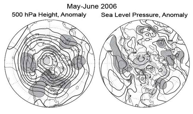
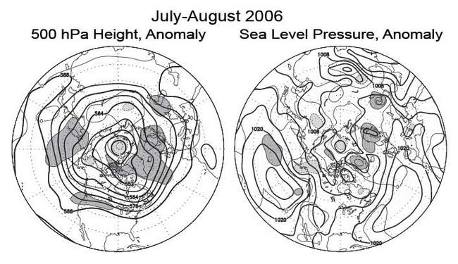
Figure legends and description of units:
The charts on the left shows the seasonal mean 500 hPa height contours at 60 m intervals in heavy solid lines, with alternate contours labeled in decameters (dm). Positive height anomalies are contoured in light solid lines at 30 m intervals, and light dashed lines show negative height anomalies. Areas of mean height anomalies more than 30 m above normal have heavy shading, and areas of mean height anomalies more than 30 m below normal have light shading.
The charts on the right show the seasonal mean sea level pressure (SLP) at 4 hPa intervals in heavy solid lines, labeled in hPa at selected intervals. Anomalies of SLP are contoured in light lines at 2 hPa intervals, with dark shading and solid lines in areas more than 2 hPa above normal, and light shading with dashed lines in areas greater than 2 mb below normal.