Historical Nautical Charts Collection: New York Harbor
Pot Rock and Way's Reef, Hell Gate
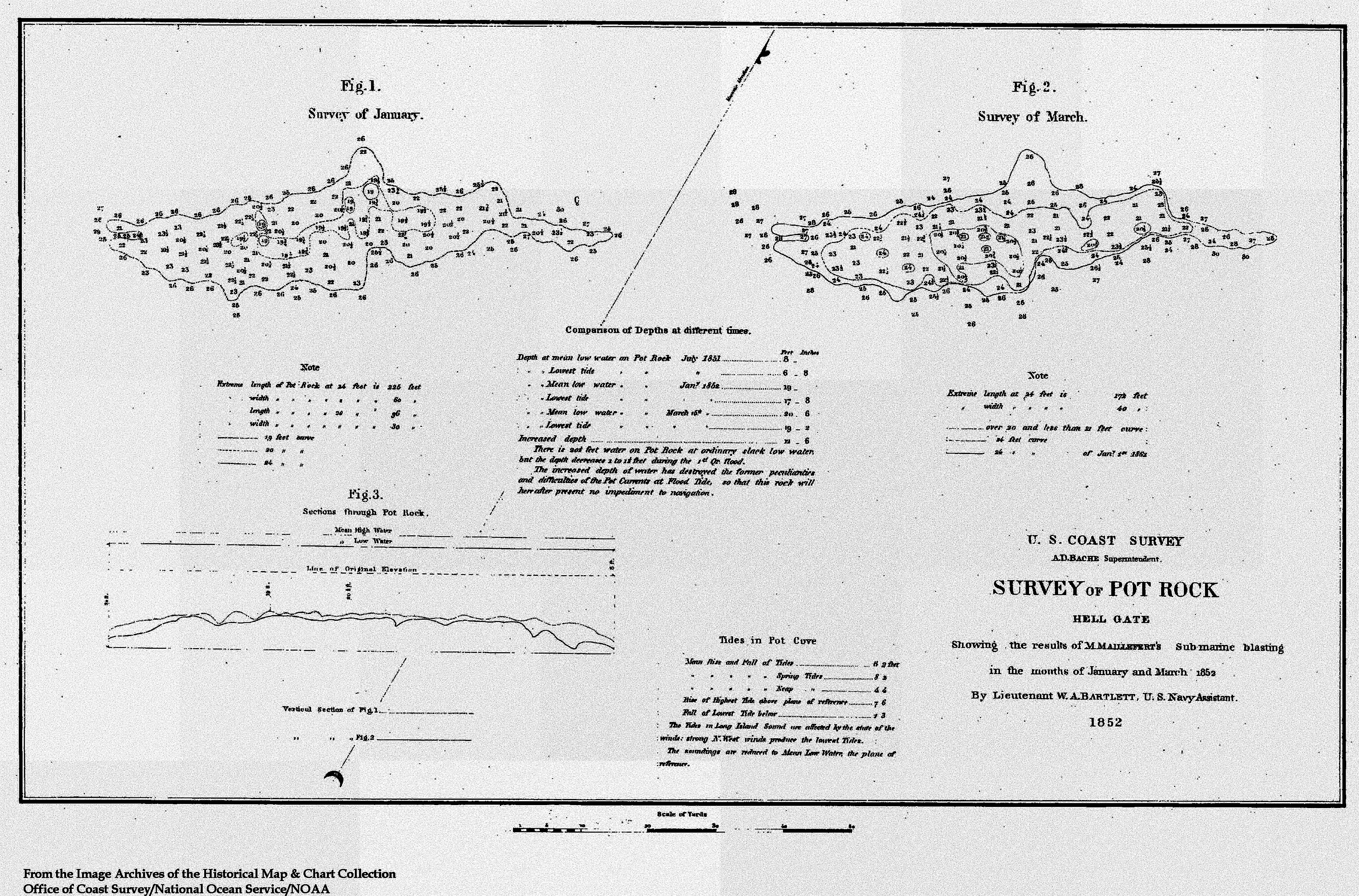
Figure 5. This particular nautical chart depicts Pot Rock in 1852. Pot Rock was one many rocks
within Hell Gate eventually blown away. Hell Gate is a narrow channel on the East River at the confluence of the
Harlem River that connects Long Island Sound with New York Harbor. The strong currents and dangerous rocks of Hell
Gate were notorious for causing ships to lose control and run aground or sink.
(Click the image to enlarge.)
This nautical chart, Figure 5, includes two depictions of the same geographic area. The left graphic is based on a hydrographic survey conducted in January of 1852, and the graphic on the right is based on a survey conducted in March of the same year.
Although this chart includes tidal observations and a cross section through the area, little additional information is shown on the chart, probably because the chart was primarily designed to show (in detail) the results of submarine blasting to remove potentially dangerous rocks.
Historic Reference
The blasting of Pot Rock was one of the earliest examples within the U.S. Coast Survey of a desire to modify the environment for human benefit. In 1848, Charles Henry Davis and David Dixon Porter suggested that Way's Reef, Pot Rock, and other rocks be removed from Hell Gate between Long Island Sound and the Hudson River. Acting on this suggestion, a group of New York citizens hired a French engineer, a Mr. Maillefert, to blast rocks out of the channel. Between blasts, a Coast Survey hydrographic crew measured the changing depths and configuration of the rocks in the blasted areas. This nautical chart is the result of these surveying efforts.
Over 30,000 cubic feet of rock were removed at Pot Rock, and its depth was increased from six feet to 20 feet. Other obstructions were removed during blasting, making Hell Gate safer for vessels traveling between the Hudson River and Long Island Sound. Coast Survey Superintendent Alexander Bache was quoted as saying that "the first edition [of the Hell Gate chart] will serve as a historical record of no small value and interest."
Works Consulted:
Kornblum, W. (2002). At Sea in the City: New York from the Water's Edge (Chapter 7) [Electronic version]. New York, New York: Algonquin Books of Chapel Hill. http://www.newyorkhistory.info/Hell-Gate/
Theberge, A.E. (2001). Volume I of the history of the commissioned Corps of the National Oceanic and Atmospheric Administration: Part 1 - The Hassler legacy. Retrieved June 20, 2006, from: http://www.lib.noaa.gov/edocs/BACHE4.htm.