Mean Circulation Highlights and Climate Anomalies
January through April 2007
A. James Wagner, Senior Forecaster, Climate Operations Branch Climate Prediction Center /NCEP/NWS/NOAA.
January - February 2007
The circulation pattern over the Northern Hemisphere during January and February was characterized by generally below normal 500-hPa heights at middle to high latitudes, while above normal heights prevailed at middle latitudes of the eastern Pacific and at lower latitudes of the eastern Atlantic and over North Africa, as well as across much of the middle latitudes of central and eastern Asia and the western Pacific. This resulted in slightly stronger than normal westerlies across the Pacific somewhat to the north of their normal position, but sea level pressures were above normal over most of the north Pacific Basin indicating an overall lack of intense storminess. At very high latitudes, especially in the vicinity of Greenland and the North Atlantic, heights were noticeably above normal, contributing to a marked negative value of the North Atlantic Oscillation (NAO) Index. By way of contrast, from eastern North America to eastern Europe, 500 hPa heights and sea level pressures were generally below normal at middle latitudes, indicating active and rapidly-moving storms taking paths somewhat south of their normal position across the North Atlantic.
Mean height and pressure anomalies were rather weak over the U.S., but averages were deceiving as far as the weather was concerned. The mild pattern of December over the eastern U.S. persisted into the first half of January, but around the middle of the month there was a marked change to a regime that delivered very cold Arctic air to much of the eastern and north-central U.S., which continued through most of February. During the period of transition, several nights of subfreezing temperatures caused extensive crop damage in parts of California and Arizona. Overall, the two-month period featured mostly below normal temperatures, especially over the eastern and central U.S., which is what usually occurs when the NAO index is negative during the colder part of the year.
Alaska also experienced a mixture of climate regimes during January and February, but had a reversal of its own. In January, above normal temperatures prevailed over the southeastern part of the state with near normal values elsewhere, but in February the mildest weather relative to normal was over northwestern areas as a southerly flow from the Bering Sea brought maritime air to coastal areas, while temperatures went below normal over the southeastern part of the state.
Storminess was frequent over northern and central Europe, and an intense system brought damaging hurricane force winds to parts of Britain and central Europe around the middle of January. Very few significant storms affected southern Europe and the Mediterranean area, which experienced a rather dry winter.
March - April 2007
During March and April, the circulation pattern changed again, and the two months had rather different weather regimes in most areas. The mean pattern for the two-month period reflects more what happened during March. A deep trough and sea level low was located over the extreme eastern Gulf of Alaska, close to the Alaska Panhandle, while to the south a strong ridge of high pressure stretched from the eastern Pacific across the California Coast and interior West to the central U.S., although below normal 500-hPa heights and sea level pressures off the Canadian Maritimes continued to deliver some cold air to the northeastern U.S. During March, stronger than normal westerly flow across western Canada and the northwestern U.S. kept most of the Arctic air bottled up in Canada, allowing most of the Lower 48 States to experience pleasant early spring weather. The generally anticyclonic conditions and lack of southerly flow kept extensive moisture out of most of the country, leading to worsening drought conditions, especially over the Southwest and the Southeast, both of which experienced one of the driest winters on record.
The combination of a strong ridge over the Bering Sea and the low near the Panhandle delivered Arctic air to most of Alaska, especially during March. Some locations experienced the coldest March on record, along with subnormal precipitation. Over the Atlantic and Europe, the NAO Index went strongly positive, and storms retreated far to the north while most of Europe experienced relatively benign weather. Changes in the circulation at high and middle latitudes during April brought milder and wetter conditions to most of Alaska as the Aleutian Low became stronger than normal close to its usual position. The air over eastern Canada remained colder than normal, and with a redevelopment of the trough over the northeastern U.S. and western Atlantic, storminess increased and below normal temperatures returned to much of the eastern and central U.S. The most intense noreaster of the entire season affected the Middle Atlantic States and New England around the middle of the month, bringing record flooding rains to northern New Jersey and the New York City area, along with damaging gale-force winds to coastal areas ahead of the storm, and to most of the Atlantic States as far south as the Carolinas in the wake of this system. Although not reflected on the maps depicting average conditions for the whole two-month period due to the fair weather that prevailed most of the time, winter storms seemed to repeatedly zero in on the Colorado Front Range and western High Plains since late in 2006. The last in the series brought record heavy snow to some mountain locations and heavy rain to lower elevations during the last week of April.
The Tropics
The first four months of 2007 featured an unusually rapid transition from weak El Nino conditions back to the cold (approaching La Nina) half of an ENSO-neutral state. The strength of El Nino had briefly peaked in late November and early December 2006, and was already declining by the beginning of 2007. The east-west contrast of above normal temperatures over the western equatorial Pacific and below normal SSTs over the eastern and central Pacific strengthened throughout the period, although there was a pause during April.
Climate impacts were quite mixed, with heavy rains and floods affecting parts of the Philippines and Indonesia, and tropical cyclones hitting northern and western Australia in a manner more typical of La Nina, but a six-year drought continued over the rest of Australia. Subnormal precipitation over Australia often accompanies El Nino, although the length of this dry period suggests that factors other than ENSO were involved. Some Madden-Julian Oscillation (MJO) activity was evident, but most of the time it was quite weak. Due in part to a period of stronger than normal trade winds, the above normal SSTs over the eastern equatorial Pacific early in the year did not last sufficiently long or approach close enough to the 27 C threshold to generate anomalous convection over that area. As a result, impacts of the rapidly waning El Nino on North American winter climate were essentially negligible.

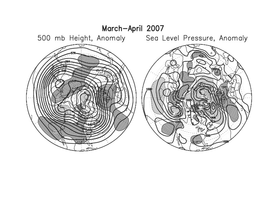
Figure legends and description of units:
The charts on the left, Figures 1 and 3, show the seasonal mean 500 hPa height contours at 60 m intervals in heavy solid lines, with alternate contours labeled in decameters (dm). Positive height anomalies are contoured in light solid lines at 30 m intervals, and negative height anomalies are shown by light dashed lines. Areas of mean height anomalies greater than 30 m above normal have heavy shading, and areas of mean height anomalies of more than 30 m below normal have light shading. (Click the image to enlarge.)
The charts on the right, Figures 2 and 4, show the seasonal mean sea level pressure (SLP) at 4 hPa intervals in heavy solid lines, labeled in hPa at selected intervals. Anomalies of SLP are contoured in light lines at 2 hPa intervals, with dark shading and solid lines in areas more than 2 hPa above normal, and light shading with dashed lines in areas greater than 2 hPa below normal. (Click the image to enlarge.)