Good Buoy! - The First of the 'Winter' Wave Events.
Ian T Hunter, Manager: Maritime Services, South African Weather ServiceDuring 2003 the South African Department of Environmental Affairs and Tourism's vessel, the SA Agulhas, deployed 43 drifting weather buoys. Of this total, 24 belonged to the South African Weather Service (SAWS).
How do you get them back? This is a common question put to SAWS personnel when people see a photo of one of the drifting weather buoys (as shown below). When told that all this equipment (sensors, satellite transmitter, battery pack etc.) is simply thrown into the sea and left to drift with the ocean currents, the usual response is one of shock. 'What a waste of money!'
This is by no means the case. Were it not for the 'drifter' network the Southern Ocean would remain a data desert. The intensity of deep mid-latitude cyclones would be seriously underestimated at times. And wave predictions would be a lot less accurate.
On Thursday morning 22 April a huge, 6m south-westerly swell started to push eastwards across the Agulhas Bankthe first really heavy swell of the winter season. SAWS has access to the output of two global wave prediction models: one run by the Meteorological Office in the United Kingdom and the other the NOAA WAVEWATCH III model run in the United States. Both models were predicting these conditions, to within a few hours and a half-metre in wave height - 5 days ahead of the event!
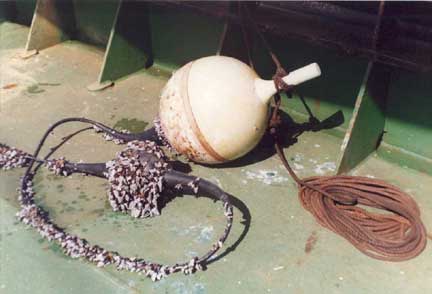 |
One that did not get away. |
Quite apart from its effect on all types of vessels transiting the Bank, this type of wave condition may have a very disruptive effect on the offshore oil and gas industry located in these waters. And once this swell moves into the fast flowing - and opposing Agulhas Current, there is always the potential for abnormally high, episodic waves to occur. These are the so-called 'freak' waves which have been known to break a vessel in two off our east coast.
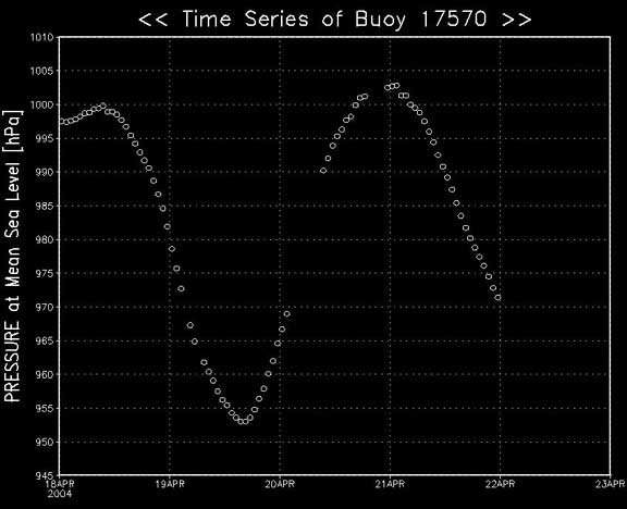
So how is it that these wave models are so smart? Very good physics no doubt. But they also need input data. Buoy 17570 was deployed from the SA Agulhas on 19 January 2004. The ship was then mid-way between Bouvet Island and the South Sandwich Islands, making her way back to the ice shelf after a special buoy deployment cruise. The barometric pressure readings from buoys such as this one helped the atmospheric models to accurately analyse and predict the winds at those high latitudes. These winds were then fed into the wave prediction models.
Thank you to all those 'ships of opportunity' that have helped to spread these buoys around the global oceans.
 |
|
Barometric pressure trace from Buoy 17570. The minimum pressure of 953 hPa indicates the passage of the rapidly-intensifying low pressure system. Three days later the resultant Southwesterly swell reached the South African coast. |
Page last modified: