In Real-Time-How VOS Observations and PMOs Can Make a Difference!
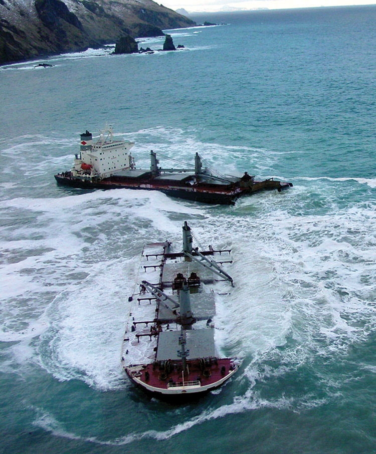
Jim Jones, Chief: Data Acquisition Branch, NOAA's National Weather Service Alaska Region, Anchorage, AKPhotos courtesy of US Coast Guard Unified Command.
 |
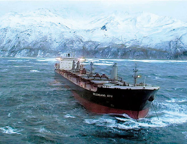
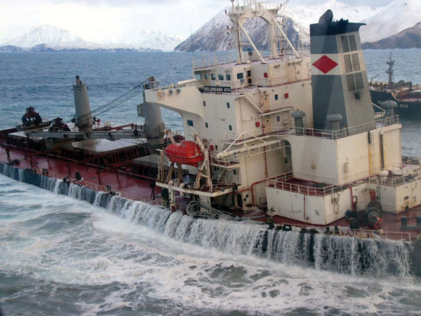
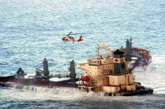
On December 6, 2004, the 738-foot, Malaysian-flagged freighter, M/V Selendang Ayu, experienced engine trouble in the Bering Sea near Unalaska Island in the eastern Aleutians during a raging winter storm. On December 8th, while an attempt was made to tow the ship offshore, the tow rope broke and the Selendang Ayu's anchor was unable to hold. The vessel went aground near Skan Bay, a remote isolated area west of Dutch Harbor, Alaska.
The following is a summary of the actions taken to develop weather support for the initial rescue efforts, and its evolution into support for a longer-term hazmat cleanup and salvage operation. VOS ship observations were critical in helping forecasters, search and rescue, and hazmat responders evaluate atmospheric and oceanic conditions in this data sparse section of Alaska. VOS participants and Port Meteorological Officers (PMO's), through their cooperative efforts, were vital in support of this incident response.
During the afternoon of December 8th, shortly before the grounding, NOAA's HAZMAT Coordinator contacted NOAA's Weather Forecast Office (WFO) in Anchorage and requested a weather briefing on observed and forecast conditions affecting the north side of Unalaska Island. The only observations immediately available to forecasters were from Dutch Harbor, approximately 30 miles to the east, which are not always representative of the conditions in or near Skan Bay. The Foss Maritime Tug Sidney Foss, a Seattle-based VOS participant, who had attempted to take the Selendang Ayu in tow, had provided several observations from the area prior to and for a few days after the grounding. Another call from NOAA's HAZMAT about an hour after the first call indicated that the ship had in fact run aground and they were now requesting twice daily weather briefings and access to all available observations until further notice. In addition, NOAA's Alaska Aviation Weather Unit (AAWU) worked in conjunction with the WFO to provide combined marine and aviation forecast packages to support the U. S. Coast Guard (USCG) and Federal Aviation Administration (FAA), who were involved in early Search and Rescue operations.
|
Between the first two calls from NOAA HAZMAT, Anchorage forecasters received a 0000Z ship report from the M/V Arctic Sun (ELQB8), one of Alaska Region's top reporting VOS participants. The Arctic Sun was situated about 120 nmi west-northwest of Skan Bay, and provided forecasters with their first indications of true sea heights and verified that both wind and sea forecasts were right on target. Within the next two hours, another VOS participant, the M/V Solar Wing (ELSJ7), provided additional data from within 150 nmi of the incident site and again helped validate the existing marine forecast. During one of the early weather briefings with the USCG, requests were made for observations to be provided from the USCG Cutter at the incident site. Three and six hourly observations were provided by the CGC Alex Haley, and later by the CGC Sherman. Their observations were relayed to the USCG Communications Station at Kodiak, who passed the data to NOAA's Weather Service Office (WSO) in Kodiak, who encoded and transmitted the data. This data flow continued for about a week following the grounding until the USCG Cutters were relieved from providing assistance and security in the area by the cleanup and salvage vessels.
|

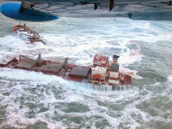
In the days immediately following the grounding of the Selendang Ayu, other forecast and observational support activity was taking place. By the end of the first week, the NWS had deployed an Incident Meteorologist (IMET) to Dutch Harbor to provide direct forecast support to the Unified Command overseeing the cleanup and salvage effort. In addition, the NWS installed an automated weather station on a bluff north of the incident site to provide hourly observations.
|

From the time this incident first came to light, and especially during the first couple of weeks, PMO's Rich Courtney (Kodiak) and Larry Hubble (Anchorage) helped coordinate VOS data collection efforts. They identified which vessels would be in the area and the easiest means by which to communicate with those vessels. Due to the remoteness of the incident site, it was hard to count on one specific communications method to work continuously. HF/SSB, satellite phone, cell phone, and VHF all have their limitations in that particular area of the Aleutians.
 |
In particular, Rich was able to contact the parent company of the salvage tug Redeemer, Magone Marine (based in Dutch Harbor) and was able to recruit the two into the VOS program. They provided twice daily observations from the incident site while on-station. Larry followed-up Rich's efforts by shipping a barometer to the tug, then he remotely worked with the Redeemer crew to calibrate the barometer and provide them observational training. Additional data was provided by the VOS ship R/V Tiglax, who was part of the salvage and cleanup effort-critical on-site wind and sea data continued.
Another way in which these two PMO's helped IMET's and operational forecasters in Anchorage was to share known metadata and data quality characteristics about the various VOS and MAREP vessels in the area, which comes from an effective near real-time quality control program, which both PMO's utilize in their daily routines. Their knowledge of the ships providing observations in and around the area helped bolster the forecasters confidence levels in the quality of the data being used to make critical decisions.
A quote from Eddie Zingone, Marine Focal Point, WFO Anchorage: "From the perspective of a forecaster writing a hazmat forecast, or any marine or near-shore forecast for that matter, the ship reports received from vessels participating in the VOS program are gold! There is no better way to both write a quick and accurate forecast, and to verify the existing forecast than with these observations."
There may be a tendency to view the VOS program from the "big picture"-as mainly used in support of large scale surface analysis through six hourly synoptic observations, and to provide valuable climate data over the data sparse oceans. In addition, there is a similar generic view of Port Meteorological Officers as non-operational staff who support these functions. This article was written in the hopes of highlighting the value of close proximity (~150 nmi) VOS observations in support of dynamic and evolving near-shore operational forecasts, and how PMOs can become an integral part of an operational scenario by providing liaison with various marine interests and help in coordinating marine data collection and data quality control.
Page last modified: