In the Wake of a Destructive Typhoon: Cold Water, Low Tides, and Fog
Sarah A. Prior, Meteorologist, National Oceanic and Atmospheric Administration (NOAA), and Charles 'Chip' Guard, Warning Coordination Meteorologist, National Oceanic and Atmospheric Administration (NOAA)Cold up-welled water and dense fog are formidable companions to mariners setting sail off the coast of California, Peru and the Cape of Good Hope. Most mariners would agree that these companions are happily forgotten when boating in more tropical parts of the ocean. However, mariners beware! Under certain conditions, cold up-welled water, fog and lower than normal tides can be found in tropical regions. A case in point occurred in the days following April 9, 2004, when the island of Yap of the Federated States of Micronesia in the western North Pacific was struck by Typhoon Sudal. The devastation left in Sudal's wake came as no surprise, but the cold ocean temperatures, low tides and fog were most unexpected.
Yap Island rarely gets a direct hit from a typhoon. In fact, before Sudal, it had been some 50 years since a typhoon hit the island. Many local islanders attribute this good fortune to magic. Typhoon Sudal developed early in the year in Chuuk State, and as it intensified on a west-northwest track, it appeared that it would move midway between Guam and Yap. However, south of Guam, Sudal began to move toward the west, and eventually southwest toward Yap.
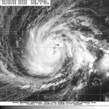
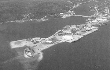
On the morning of April 9, Sudal began to lash the island with typhoon force winds. The center of the eye of the typhoon passed about 15 nmi south of the island around noon (Figure 1). The peak wind recorded was observed at the International Airport in the early afternoon-a gust of 97 kts. The lowest observed pressure was 958.5 hPa, also at the airport. The strongest winds hit the extreme south end of the island, which also experienced a brief eye passage and an 11-foot storm surge. Local weather people and emergency managers had the 15,000 residents prepared for the typhoon. As a result, there was not a single death or serious injury. Devastation was widespread, amounting to around 14 million dollars. The capital city of Colonia and Yap's harbor experienced storm surges of 8 and 9 feet, respectively. Figure 2 shows the heavy coastal erosion at the entrance to the port. Tropical Storm and Typhoon winds in tropical regions of the Pacific are categorized according to the Saffir-Simpson Tropical Cyclone Scale (Guard and Lander, 1999), which relates maximum tropical cyclone wind speed to potential damage and storm surge. Despite being only 9 nmi from north to south, the island experienced Typhoon Category 1 winds (1-minute sustained winds of 64-82 kts) on the north side, Typhoon Category 2 winds (1-minute sustained winds of 83-95 kts) in the central region, and Typhoon Category 3 winds (1-minute sustained winds of 96-113 kts) on the extreme south end.
|
After passing Yap, Sudal took a northwest track, and a day later, had sustained winds of 135 kts. While the typhoon itself was of great interest, the remainder of the story concentrates on what occurred on and near Yap after its passage-low tides, cold water, and fog.
It is well-known that tropical cyclones induce a sea surface temperature (SST) cold wake preferably to the right of the tropical cyclone track (Price, 1981). SST's measured in the wake of Hurricane Gilbert in 1988 in the Atlantic basin decreased about 4°C in the storm's wake located to the right of the track (Jacob and Shay 1999). SST's derived from the Tropical Rainfall Measurement Mission (TRMM) satellite showed a patch of 3°C SST cold wake in the western Pacific after the passage of Typhoon Rusa (Huang, Wu and I-Lin, 2002). During Hurricane Isodore's passage over the Yucatan Shelf, strong upwelling caused 4°C cooling (Zhao and Chen, 2002).
|
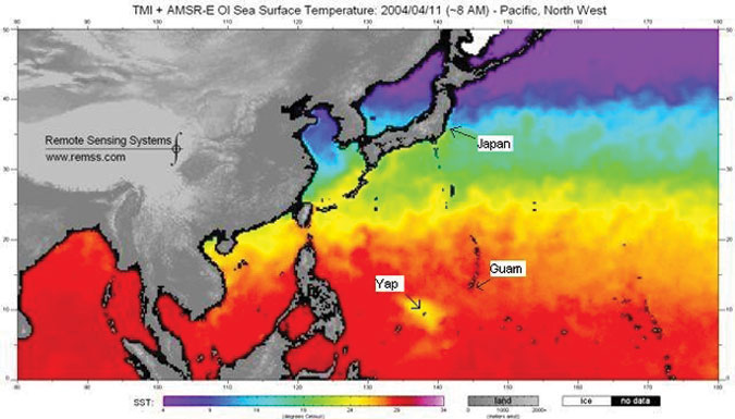
Figure 3. SST composite from satellite microwave sensors TMI (onboard TRMM) and AMSR-E generated two days after Typhoon Sudal made eye passage on the southern tip of Yap. |
The SST composite in Figure 3, generated two days after Sudal's passage on Yap, shows a cold wake of 6°C, similar in magnitude to previous studies. In Figure 3, the cold wake near Yap has a SST around 24°C, whereas the waters in the rest of the equatorial western Pacific are closer to 30°C. Before Sudal's passage, waters around Yap were also near 30°C.
The cold up-welled water, which occurred in Sudal's wake, had an interesting effect on the Yap's weather. The Weather Service Office on Yap reported fog for several hours in the weather observations. In addition, residents of Yap reported seeing fog, feeling much cooler ocean waters, and observing significantly lower tides.
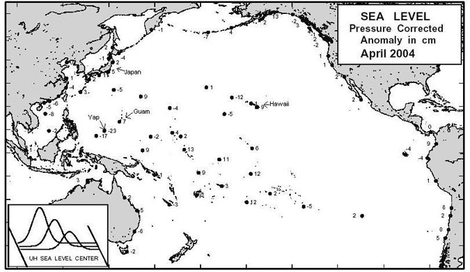
Shay, Chang and Elsberry (1990) modeled the ocean response to Hurricane Fredric and found that the sea level depression in the wake of Fredric was around 20 cm along the storm track. They demonstrated that the sea surface depression was induced by the hurricane's wind stress and the surface Ekman divergence (Shay and Chang 1996). Western Pacific sea level anomalies generated from University of Hawaii's Sea Level Center show the April 2004 sea level anomaly for Yap to be -23 cm in (Figure 4). This monthly anomaly was significantly greater than those of the surrounding islands and of similar magnitude to model results of Shay et al.
|
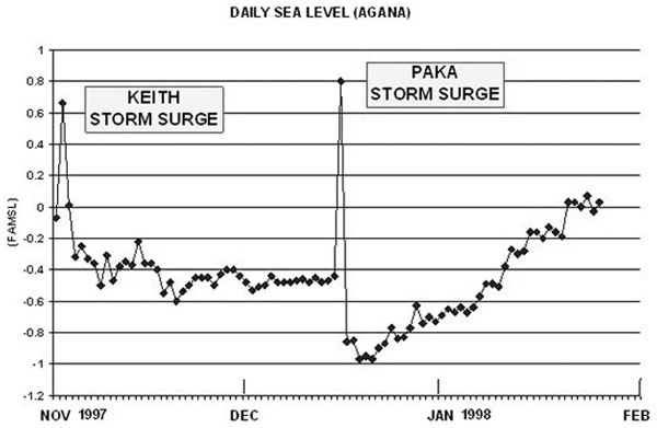
Similar negative anomalies in the wake of tropical cyclones have been observed on Guam. After Super Typhoon Keith (1996), Super Typhoon Paka (1997) and Super Typhoon Pongsona (2002), there were dramatic drops in the sea level and tides after the initial storm surge subsided (Figure 5).
With a tidal range not much greater than 3 ft in the Mariana Islands of the western North Pacific, a 1-ft depression in tides is quite obvious to local residents. Local surfers on Guam were so surprised by the 1-ft depression in tides that they thought the reef was moved by Typhoon Pongsona.
When threatened by a hurricane or typhoon, seamen take great pains to avoid the gale-force and stronger winds. They often wait until the storm has passed and then follow in the wake of the storm, well behind the winds. However, the up-welled area of colder water in the wake of the storm may produce some dense fog, and mariners should be aware of what could be waiting just beyond the horizon.
It is interesting to note that recent studies modeling the cold wake and sea level depression have compared well to observations from islands of the western Pacific experiencing tropical cyclone passage. It will be difficult to forecast fog based on these findings, but mariners should be on the lookout for such occurrences! And, don't depend on tide tables under these conditions, or you may find your boat high and dry!
References
Guard, C. P., and M. A. Lander, 1999: "A scale relating tropical cyclone wind speed to potential damage for the Pacific Ocean region-A user's manual." WERI Technical Report 86. Water and Environmental Research Institute, University of Guam, Mangilao, Guam 96910, pp. 60.
Huang, T., C. Wu, and I. Lin, 2004: "The Impact of SST Cold Wake Induced by Typhoon Rusa (2002) on the Intensity Evolution of Typhoon Sinlaku (2002)." 26th Conference on Hurricanes and Tropical Meteorology, pp. 657-658.
Jacob, S.D., and L. K. Shay, 1999: "Upper Ocean Response During Hurricane Gilbert: Observational and Numerical Studies." 23rd Conference on Hurricanes and Tropical Meteorology, pp. 1041-1044.
Price, J. F., 1981: "Upper Ocean Response to a Hurricane." J. of Phys. Oceanogr., 11, pp. 153-175.
Shay, L. K., S. W. Chang, and R. L. Elsberry, 1990: "Free Surface Effects on the Near-Inertial Ocean Current Response to a Hurricane." J. of Phys. Oceanogr., 20, pp. 1405-1424.
Shay, L. K., and S. W. Chang, 1996: "Free Surface Effects on the Near-Inertial Ocean Current Response to a Hurricane: A Revisit." J. of Phys. Oceanogr., 27, pp. 23-39.
Zhao, W., S. S., and J. Tenerelli, 2004: "Upper Ocean Response and Feedback to 2002 Hurricane Isodore and Lilli in Tandem." 26th Conference on Hurricanes and Tropical Meteorology, pp. 615-616.
Page last modified: