Waves of Power-Tsunami
Jim Luciani, National Weather Service, Port Meteorological Officer New York/New Jersey |
Image courtesy of USGS |
The spoken word "Tsunami" whose immense power was widely known within the marine community prior to Dec 26, 2004, will get a different reaction from everyone now that this infamous day is part of history.
That day will be remembered for one of the most destructive and deadly natural catastrophes known to modern man. Over 150,000 dead (only the Bangladesh Typhoon of 1970 (500,000) and China Earthquake of 1976 (240,000) killed a larger number), more than 500,000 injured, billions of dollars in damage! How could a phenomena of this power strike with no warning? Is it possible that a ship at sea let these huge waves pass by unnoticed? Unfortunately for those ashore, it is unlikely that a ship at sea could have noticed this killer. The waves were deep in the ocean and nearly imperceptible from the surface. It is only when the waves begin to interact with the shallow waters of the coastlines that they take their destructive shape as a series of "giant waves."
Scientists know that it was a powerful earthquake along the sea floor that spawned the waves. It measured 9.2 on the Richter scale, releasing energy equivalent to 475,000 kilotons (475 megatons) of TNT, or the energy of 23,000 Hiroshima bombs. One side of the fault along which the earthquake developed slipped beneath the other, thrusting one of the plates rapidly upward (seismologists speculate a 50 foot slip in a matter of seconds) while pushing the water above it upward, creating a series of waves along the ocean floor.
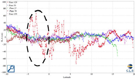 |
Image displays the Sea level anomalies measured by the Jason-1 altimetry satellite in red at the time of the tsunami (the other curves show measurements made at other times, for comparison). The areas corresponding to the first wave are circled. The left scale is cm, the bottom degrees latitude. Image courtesy of Aviso, CEA and CLS. |
These waves, with heights usually less than a foot, can have wavelengths of nearly 60 miles, have periods of 10 minutes to 1 hour, and travel at speeds in excess of 500 mph. It is the long wavelengths that enable it to move with such speed and to retain nearly all of its power as it approaches shore. Once the waves begin to feel the bottom, they begin to rise to terrifying heights. The only warning visible to those ashore may be a pronounced and very unusual withdrawal of water in the shallows, as if the waves were gathering themselves for a violent rush onshore.
 |
Image shows corresponding ground track for Jason-1. Image courtesy of Aviso, CEA and CLS |
What should ships do if they receive word that a tsunami is approaching? According to NOAA, UNESCO/Intergovernmental Oceanographic Commission (IOC) and the International Tsunami Information Center (ITIC):
- Since tsunami wave activity is imperceptible in the open ocean, do not return to port if you are at sea and a tsunami warning has been issued for your area. Tsunamis can cause rapid changes in water level and unpredictable dangerous currents in harbors and ports.
- If there is time to move your boat or ship from port to deep water (after you know a tsunami warning has been issued), you should weigh the following considerations:
- Most large harbors and ports are under the control of a harbor authority and/or a vessel traffic system. These authorities direct operations during periods of increased readiness (should a tsunami be expected), including the forced movement of vessels if deemed necessary. Should a forced movement of vessels be directed, keep in contact with the authorities.
- Smaller ports may not be under the control of a harbor authority. If you are aware there is a tsunami warning and you have time to move your vessel to deep water, then you may want to do so in an orderly manner, in consideration of other vessels. Owners of small boats may find it safest to leave their boat at the pier and physically move to higher ground, particularly in the event of a locally-generated tsunami. Concurrent severe weather conditions (rough seas outside of the harbor) could present a greater hazardous situation to small boats, so physically moving yourself to higher ground may be the only option.
- Damaging wave activity and unpredictable currents can affect harbors for a period of time following the initial tsunami impact on the coast. Contact the harbor authority before returning to port making sure to verify that conditions in the harbor are safe for navigation and berthing.
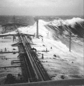
The tsunami is not the only large wave that threatens ships. "Rogue waves" are a far more ominous threat to ships at sea than is a tsunami. These freaks of nature have claimed a number of large commercial ships as victims of its powerful force. For years the mariner has reported encounters with waves upwards of 100 ft, particularly off the southeastern coast of Africa. Scientists were often skeptical that these rogue waves truly existed, but the improvement in wind and wave observing from satellites has finally proved what the mariner knew to be true all along. Now with the help of Scatterometry a group of scientists are attempting to find these waves, document the conditions that helped create them, and develop a tool to forecast their occurrences.
 |
|
Phillipe Lijour aboard the tanker Esso. Languedoc captured this image in 1980 when the ship was struck by a rogue. The mast visible on the starboard side is 25m above sea level. |
Image courtesy of www.thephora.org |
What have scientists discovered about the causes of these monster waves? A team of German oceanographers were able to create similar waves in a tank. Their theory about the waves' cause is that slow moving waves are caught by larger, longer period waves (the longer the period the faster the wave) moving nearly twice their speed. The waves pile on top of each other creating a huge set of waves that are forced to collapse on themselves (with an immense release of power).
Another theory that was debated revolved around the fact that so many of these events occurred in the vicinity of strong ocean currents, specifically the Agulhas and Gulf Stream currents. When strong winds generated large waves that flowed into the current the currents acted as a barrier, forcing the waves to slow and rise to steep heights. The "North Wall Effect" is a well known and documented example of this effect.
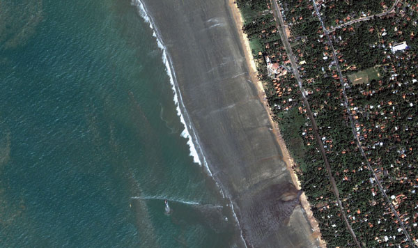 |
Sri Lanka, 26 Dec 2004 image shows "Drawback" of water exposing ~ 150 meters of "temporary" beach. |
|
Photo courtesy of www.digitalglobe.com |
It is likely that both of these factors come into play for the largest of these waves. Armed with this knowledge, a wise mariner can anticipate when the danger of rogue waves is most likely along their particular route. Unfortunately there is no technique to employ to sail out of danger (like there is with a hurricane), no advanced warning (yet!) that one or more of these are headed in your direction (like there is with a Tsunami). It is the Master, crew and ship in a pitched battle against nature, and hopefully nature loses more and more in the future. Engineers and Scientists armed with the information from the German oceanographers are already busy designing ships that can better withstand the power of these waves. The battle with nature is slowly, but gradually beginning to turn in our favor!
Page last modified: