The Gulf of Tehuantepec Hurricane Force Wind Event of 30-31 March 2003
Hugh D. Cobb, IIITropical Analysis and Forecast Branch
Tropical Prediction Center - Miami, FL
|
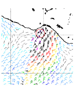
Figure 1. 25 KM resolution Quikscat image from the 2358 UTC 30 March 2003 pass. The red circle contains the location of hurricane force winds. |
The Tropical Analysis and Forecast Branch (TAFB) of the Tropical Prediction Center (TPC) has been documenting Gulf of Tehuantepec gale and storm events that have occurred since the advent of QuikSCAT Scatterometer data in 1999. The Gulf of Tehuantepec averages 16 wind events that are of gale intensity or stronger each winter season (Cobb et al., 2003). Several wind events attained wind speeds exceeding 48- kt storm force. On rare occasions sustained winds reach hurricane force. One such instance occurred 30-31 March 2003. The hurricane force wind event of 30-31 March 2003 was the strongest in the Gulf of Tehuantepec since the inception of QuikSCAT imagery. A 25 km spatial averaged QuikSCAT image from the 2358 UTC 30 March 2003 pass (Figure 1) indicated 65 kt winds within a fairly large area of 50-60 kt storm force winds. The higher resolution 12.5 km QuikSCAT imagery from the same time indicated several wind vectors in the 65-70 kt range.
Setting the Stage for an Extraordinary Wind Event.
The 30-31 March wind event was an extraordinarily strong wind event for the Gulf of Tehuantepec.
This was a late season event occurring six weeks after the last documented gale event in the area for the season. The time lag between significant wind events allowed the waters in the Gulf of Tehuantepec to recover from upwelling effects induced by the presence of such strong wind events. A 10 km resolution sea surface temperature (SST) analysis from the Naval Oceanographic Office on 27 March 2003 (Figure 2) indicated STET had reached 27-28C with a pool of greater than 29C water nearby. The potential then existed for winds at higher elevations to mix down to the surface due to the presence of an unstable boundary layer generated by the warm SSTs. In addition ambient surface pressures were 1 to 2-hPa lower in late March than they were in January and February. This effectively added to the potential pressure gradient across the Chivela Pass. Therefore, the potential for much stronger winds existed.
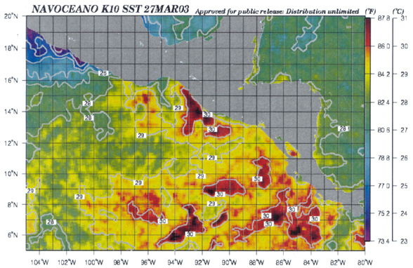 |
Figure 2. 10KM SST analysis from 27 March 2003. Image courtesy of Bruce McKenzie at the Naval Oceanographic Office. Note the presence of 27-28 degree C SSTs in the Gulf of Tehuantepec. |
Forecasting a Late Season Tehuantepec Event
The Tropical Analysis and Forecast Branch (TAFB) of the Tropical Prediction Center has high seas forecast responsibility for the tropical eastern North Pacific Ocean from the Equator to 30C N and east of 140C W to the west coast of Mexico and Central America. The High Seas Forecasts are issued four times a day and are a forecast of winds, sea heights and significant weather out to 48 hours. Marine forecasters in TAFB routinely use output from numerical weather prediction (NWP) models to help them forecast marine weather elements (locations of frontal systems and associated weather, wind speed and sea heights) in their area of responsibility. Output from one of the numerical models, the Global Forecast System (GFS) indicated the potential for a strong gale event as early as 28 March 2003. The first High Seas Forecast for the tropical eastern North Pacific to mention the possibility of a gale event in the Gulf of Tehuantepec was issued at 2230 UTC March 28 and indicated winds of 30 to 35 KT would begin in 42 hours, around 1200 UTC 30 March, and increase to 40 KT by 1800 UTC 30 March. At 1030 UTC 29 March 2003 the gale warning was upgraded to a storm warning with gale conditions forecast to begin around 0000 UTC 30 March 2003 and increase to storm conditions by 1200 UTC 30 March with winds of 45 to 55 kt. In the 2230 UTC 30 March 2003 High Seas Forecast, winds were forecast to increase to 60 KT by 0000 UTC 31 March. The forecast increase in winds was based on an observed anticyclone in the 1800 UTC 30 March surface analysis that was 4-5-hPa stronger than forecast by the GFS model. The forecaster took into account the expected impacts of the stronger high on the pressure gradient in the Chivela Pass.
The Event
|
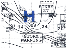
Figure 3. TPC Surface analysis from 0000 UTC 31 March 2003 |
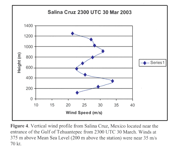
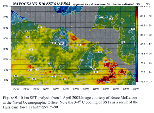
A very sharp mid-to upper-level trough had migrated eastward across the southern United States, dragging a very strong cold front deep into the western Gulf of Mexico by 1200 UTC 29 March. By 0000 UTC 30 March, the cold air had entered the northern portions of the Chivela Pass. At the same time, a 1030-hPa surface anticyclone was located over central Texas. The anticyclone had moved into northern Mexico and strengthened to 1035-hPa by 1200 UTC with storm force winds beginning in the Gulf of Tehuantepec. Six hours later the 1036-hPa anticyclone was located on the east coast of Mexico between Tampico and Veracruz with 30 KT northerly winds blowing into the northern end of the Chivela Pass near Coatzacolcos, Mexico. A close up surface analysis at 0000 UTC 31 March 2003 from the TPC (Figure 3) indicated that the strong anticyclone now 1032-hPa had pushed further south over southern Mexico and a surface pressure of 1031.6-hPa was reported at Coatzocolcos, Mexico. A pressure gradient of 16-hPa existed over the 120 nmi length of the Chivela Pass by this time resulting in hurricane force winds within the exit region of the Chivela Pass over the Gulf of Tehuantepec. Salina Cruz reported hurricane force winds with gusts approaching 150 km/h or 75 KT. A vertical wind speed profile obtained from Salina Cruz (Figure 4) indicated winds as high as 70 KT 375 m above Mean Sea Level (200 m above the station). Given the existing instability it is likely that these winds mixed down to the surface. Storm force winds occurred over a period of 42 hours from 1200 UTC 30 March through 0600 UTC 1 April. Gale force winds occurred over a 78 hour period beginning 0000 UTC 30 March and ending 0600 UTC 2 April. This was also the longest single wind event with storm force winds since documentation of these events began in 1999. The strong winds associated with this event had a marked effect on the SSTs in the Gulf of Tehuantepec. Figure 5 is a 10 km resolution sea-surface temperature analysis from the Naval Oceanographic Office on 1 April 2003 while storm force winds were still occurring. SSTs in the Gulf of Tehuantepec cooled by 4C to 23-24C.
References
Cobb, H.D. III, Brown, Daniel P. and Robert A. Molleda. The use of QuikSCAT Imagery in the Diagnosis and Detection of Gulf of Tehuantepec Wind Events 1999-2002. Preprints 83rd Annual AMS Meeting - 12th Conference on Satellite Meteorology and Oceanography, p. 410.
Page last modified: