Eastern North Pacific Hurricane Season of 2003
John. L. Beven IINational Hurricane Center, Miami, Florida
1. Introduction
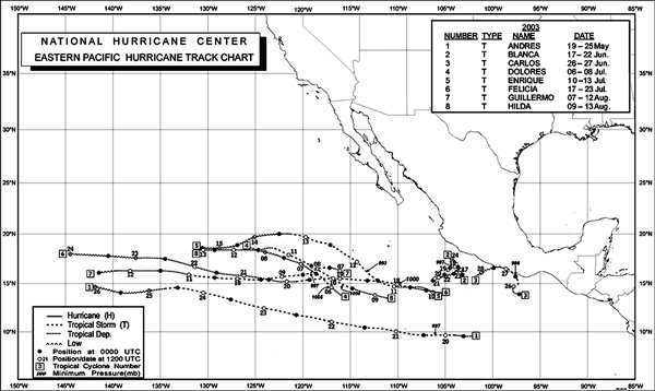
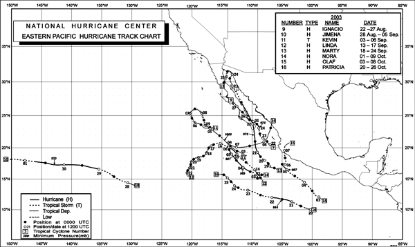
There were sixteen named tropical cyclones in the Eastern North Pacific basin in 2003, seven of which became hurricanes (Table 1, Figures 1A & 1B). These totals are similar to long-term averages of sixteen named tropical cyclones and nine hurricanes. There were no major hurricanes (category three or higher on the Saffir-Simpson Hurricane Scale) during the 2003 season. This is well below the long-term average of four major hurricanes and is the first time this has occurred since 1977. The first hurricane, Ignacio, did not form until 24 August. This is the latest observed first hurricane of record in the basin since reliable satellite observations began in 1966. There were also no depressions that did not become named cyclones. Five named tropical cyclones made landfall in Mexico. Hurricanes Ignacio and Marty came ashore in Baja California bringing high winds, storm surge, and heavy rain. Carlos and Olaf made landfall along the coast of mainland Mexico as tropical storms, while Nora and Marty made landfall in mainland Mexico as tropical depressions.
| Name | Class* | Dates** | Max. Winds (KT) | Min. Pressure (hPa ) |
Direct Deaths | |
|---|---|---|---|---|---|---|
| Andres | T | 19-25 May | 50 | 997 | ||
| Blanca | T | 17-22 June | 50 | 997 | ||
| Carlos | T | 26-27 June | 55 | 996 | ||
| Dolores | T | 6-8 July | 35 | 1005 | ||
| Enrique | T | 10-13 July | 55 | 993 | ||
| Felicia | T | 17-23 July | 45 | 1000 | ||
| Guillermo | T | 7-12 August | 50 | 997 | ||
| Hilda | T | 9-13 August | 35 | 1004 | ||
| Ignacio | H | 22-27 August | 90 | 970 | 2 | |
| Jimena | H | 28 Aug - 5 Sep | 90 | 970 | ||
| Kevin | T | 3-6 September | 35 | 1000 | ||
| Linda | H | 13-17 September | 65 | 987 | ||
| Marty | H | 18-24 September | 85 | 970 | 12 | |
| Nora | H | 1-9 October | 90 | 969 | ||
| Olaf | H | 3-8 October | 65 | 987 | ||
| Patricia | H | 20-26 October | 70 | 984 | ||
|
* T - tropical storm, maximum sustained winds 34-63 KT;
H - hurricane, maximum sustained winds 64 KT or higher. ** Dates based on UTC time and include tropical depression stage. | ||||||
| Table 1. Eastern North Pacific tropical storms and hurricanes of 2003. | ||||||
|
| ||
| Figures 1A and 1B. Eastern North Pacific tropical storms and hurricanes of 2003. | |||
In the individual summaries below, dates are based on Universal Coordinated Time (UTC).
2. Individual storm summaries
Tropical Storm Andres: Andres developed from an area of disturbed weather that formed on 15 May within a broad area of low pressure south of Guatemala. The disturbance moved westward for the next few days and organized into a tropical depression on 19 May about 920 nmi south-southeast of Cabo San Lucas, Mexico. The depression strengthened into the first tropical storm of the season early on 20 May, and maximum sustained winds reached an estimated 50 kt later that day. Andres moved west-northwestward until it began to weaken over cooler water on 24 May, at which time it turned westward. Andres weakened to a depression on 25 May and then degenerated to a non-convective remnant low later that day about 1500 nmi west-southwest of Cabo San Lucas.
Tropical Storm Blanca: Blanca formed about 210 nmi south-southeast of Manzanillo, Mexico, on 17 June and reached an estimated peak intensity of 50 kt the next day. It spent its lifetime meandering near its point of origin. (continued page 45) (continued from page 43). Southeasterly vertical wind shear caused it to weaken to a depression on 20 June and to a remnant low on 22 June. The low eventually dissipated about 100 nmi south of Manzanillo on 24 June.
Tropical Storm Carlos: Carlos formed from a tropical wave that moved westward from the coast of Africa on 14 June. Disturbed weather developed south of the Gulf of Tehuantepec on 23 June, and a tropical depression formed on 26 June about 120 nmi south of Puerto Escondido, Mexico. The cyclone moved slowly north-ward and became Tropical Storm Carlos later that day. Carlos made landfall 50 nmi west of Puerto Escondido early on 27 June with estimated maximum sustained winds of 55 kt. The storm rapidly weakened to a remnant low over the mountainous terrain of Mexico later that day. The low drifted back into the Pacific on 28 June, where it dissipated the next day.
Three ships reported tropical-storm force winds during Carlos. The Sealand Champion reported 40 kt winds at 1800 UTC 26 June, while the Raicho II reported 37 kt winds and a 1001.0-hPa pressure three hours later. A ship with the call sign NEPP reported 35 kt winds at 0000 UTC 27 June. No observations of tropical-storm force winds were available from the coast. Press reports indicate that Carlos caused minor damage in the Mexican state of Oaxaca.
Tropical Storm Dolores: Dolores was a short-lived tropical storm forming from a tropical wave that entered the Pacific on 30 June. The system became a depression about 655 nmi south-southwest of Cabo San Lucas early on 6 July and moved generally west-northwestward to northwestward through its life. The system became a minimal tropical storm later that day. Dolores weakened back to a depression early the next day under the influence of strong northeasterly vertical wind shear. The cyclone degenerated into a remnant low early on 8 July. The low dissipated on 9 July about 915 nmi west-southwest of Cabo San Lucas.
Tropical Storm Enrique: Enrique formed from a tropical wave that left Africa on 25 June and reached the Pacific on 6 July. The wave spawned a depression on 10 July about 565 nmi south-southeast of Cabo San Lucas. The cyclone becoming a tropical storm the next day. Enrique moved west-northwestward for the next two days and reached an estimated peak intensity of 55 kt early on 12 July. Later that day, Enrique began to steadily weaken over cooler water and became a tropical depression late on 13 July. The cyclone turned westward and degenerated into a remnant low pressure system on 14 July. It dissipated early on 16 July about 1200 nmi west-southwest of Cabo San Lucas.
Tropical Storm Felicia: Felicia formed from a tropical wave that left Africa on 4 July and reached the Pacific on 12 July. A tropical depression developed late on 17 July about 315 nmi south of Manzanillo. The cyclone became a tropical storm shortly thereafter and reached an estimated peak intensity of 45 kt later that same day. Felicia moved westward for the next seven days while vertical wind shear caused a gradual decay. It weakened to a tropical depression on 20 July and became a remnant low on 23 July. The low crossed 140W longitude into the central Pacific hurricane basin later that day and dissipated on 24 July about 600 nmi east of the Hawaiian Islands.
Tropical Storm Guillermo: Guillermo developed from a tropical wave that crossed Central America and moved into the Pacific on 1 August. A weak surface low developed on 6 August and became a depression the next day about 525 nmi southwest of Cabo San Lucas. The depression moved westward and strengthened into a tropical storm early on 8 August. Guillermo reached its estimated peak intensity of 50 kt later that day. Outflow from Tropical Storm Hilda caused Guillermo to weaken on 10 August, and it became a depression the next day. The cyclone degenerated to a remnant low on 12 August about 1750 nmi west of Cabo San Lucas, and the low crossed into the central Pacific hurricane basin before dissipating the next day.
Tropical Storm Hilda: Hilda formed from a tropical wave that moved westward from the coast of Africa on 27 July. The wave spawned a tropical depression about 600 nmi south of Cabo San Lucas on 9 August. It moved toward the west and west-northwest and became a tropical storm with estimated 35 kt winds later that day. That was the peak intensity, and Hilda began to weaken gradually on 11 August. A combination of cooler water and vertical wind shear caused it to dissipate on 13 August about 1200 nmi west-southwest of Cabo San Lucas.
Hurricane Ignacio: Ignacio, the first hurricane of the 2003 season, was the latest-forming first hurricane of record in the eastern North Pacific basin. It formed from a tropical wave that reached the Pacific on 16 August. A depression developed on 22 August about 190 nmi southeast of Cabo San Lucas. It moved north-northwestward, a motion that would continue for most of its existence, and became a tropical storm the next day. Ignacio strengthened further and became a hurricane on 24 August. Maximum sustained winds reached an estimated 90 kt on 24 August as Ignacio brushed the east coast of extreme southern Baja California (Figure 2). The hurricane made landfall just east of La Paz, Mexico, with estimated sustained winds of 70 kt the next day. Thereafter it weakened while moving over southern Baja California and dissipated late on 27 August over central Baja California. There were no reliable ship or land station reports of tropical-storm force winds from Ignacio. However, press reports indicate the cyclone brought hurricane conditions to the east coast of southern Baja California and widespread heavy rains to the southern and central portions of the Baja peninsula. Ignacio was responsible for two fresh-water drowning deaths in Baja California. Roads, trees, and power lines were damaged, while thousands were evacuated from coastal communities.
|
|

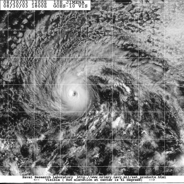
Hurricane Jimena: Jimena formed from a tropical wave on 28 August about 1500 nmi east-southeast of the Hawaiian Islands. Moving west-northwestward, the system became a tropical storm later that day and reached hurricane strength the following day. After turning westward and entering the central Pacific hurricane basin, Jimena strengthened to its estimated peak intensity of 90 kt (Figure 3). By 31 August, increasing vertical wind shear caused Jimena to weaken. The cyclone then moved west-southwestward and, after weakening to a tropical storm, passed about 100 nmi south of the southern tip of the island of Hawaii on 1 September. Jimena became a tropical depression the next day. The cyclone moved westward to west-southwestward for a few days and dissipated on 5 September just after crossing the International Date Line about 1500 nmi west-southwest of the Hawaiian Islands. Jimena brought tropical-storm force gusts to portions of the Hawaiian Islands. The island of Kahoolawe reported a gust of 50 kt, while South Point on the island of Hawaii reported a gust of 46- kt. Rainfall of 6 to 10 inches and high surf were reported on the island of Hawaii in association with Jimena. No casualties or significant damage were reported.
Tropical Storm Kevin: Kevin was a short-lived tropical cyclone that formed from a tropical wave that reached the Pacific on 28 August. The cyclone started as a broad depression early on 3 September about 245 nmi south-southwest of Cabo San Lucas. The cyclone moved northwestward parallel to the Baja California peninsula with maximum sustained winds reaching an estimated 35 kt late on 4 September. Close proximity to cold water caused Kevin to quickly weaken and it became a depression early on 5 September. It then degenerated into a remnant low early the next day about 500 nmi west of Cabo San Lucas. The remnant circulation moved slowly westward for several days before it finally dissipated on 10 September about 365 nmi west of Cabo San Lucas.
Hurricane Linda: Linda formed from a tropical wave that crossed into the Pacific on 6 September. The wave spawned a tropical depression late on 13 September about 340 nmi southwest of Manzanillo. The cyclone moved northwestward for the next two days. It became a tropical storm later on 14 September and a hurricane with estimated 65 kt sustained winds the next day. Linda turned westward and weakened to a tropical storm on 16 September, then it turned southwestward and weakened to a depression on 17 September. The cyclone weakened to a remnant low later that day about 445 nmi west-southwest of Cabo San Lucas.
 |
Figure 4. GOES-10 visible image of Hurricane Marty at 1001 UTC 22 September 2003. Image courtesy of the Naval Research Laboratory, Monterey, California. |
Hurricane Marty: Marty, which was the second hurricane to make landfall in Baja California during 2003, formed from a tropical wave that reached the Pacific on 10 September. The wave spawned a tropical depression on 18 September about 450 nmi south-southeast of Cabo San Lucas. The depression quickly strengthened into a tropical storm as it moved slowly to the west-northwest. Marty turned northwestward and became a hurricane on 21 September. Marty then moved northward toward the southern Baja California peninsula, making landfall just east of Cabo San Lucas on 22 September with maximum sustained winds estimated at 85 kt (Figure 4). Marty then moved north-northwestward along the east coast of the Baja California peninsula, weakening to a tropical storm near Santa Rosalia on 23 September and to a tropical depression later that same day. The cyclone then meandered in and around the northern Gulf of California with heavy rains but weak winds. It made one landfall as a tropical depression on 24 September near Puerto Peñasco on the Mexican mainland and another one as a remnant low the next day south of San Felipe on the Baja California peninsula. The circulation dissipated shortly after the latter landfall.
Two ships encountered Marty on 19 September. The Zim Iberia reported 35 kt winds at 0600 UTC 19 September, and this was an important observation in upgrading Marty to a tropical storm. The Leverkusen Express reported 35 Kt winds at 2100 UTC that same day. Additionally, the S. V. Sea Witch, anchored in La Paz harbor, reported a pressure of 971.9-hPa on 22 September as the center of Marty passed over. The storm brought hurricane conditions to the southern Baja California peninsula, with tropical storm conditions occurring along the east coast of central Baja California. An automated station in Cabo San Lucas reported 10-min average winds of 76 kt with a gust to 102 kt at 0900 UTC 22 September. The hurricane was responsible for 12 deaths, including two individuals listed as missing but presumed dead. Five of the deaths resulted from the sinking of a fishing boat in the Gulf of California, while five others were caused by fresh-water flooding. Media reports indicate damage to about 4,000 homes in southern Baja California. The cyclone also brought locally heavy rains to much of the remainder of Baja California, portions of northwestern Mexico, and portions of the southwestern United States.
Hurricane Nora: Nora formed from a tropical wave that entered the Pacific on 25 September. A tropical depression developed from the wave on 1 October about 525 nmi south of Cabo San Lucas and moved very slowly toward the west and west-northwest with gradual intensification for the next few days. It became a tropical storm on 2 October and a hurricane early on 4 October. Nora reached its estimated peak intensity of 90 kt later that day. It then weakened to a tropical storm on 6 October and to a depression on 7 October while it turned to the east and then northeast. The cyclone reached the coast of Mexico just north of Mazatlan on 9 October and soon dissipated over high terrain. Nora caused locally heavy rains in the Mexican state of Sinaloa, but there were no reports of damages or casualties.
Hurricane Olaf: Olaf formed from a tropical wave and became a tropical depression on 3 October about 325 nmi south-southeast of Acapulco, Mexico. It strengthened into a tropical storm later that day while moving slowly northwestward. This motion continued for two days while Olaf gradually strengthened to a hurricane with estimated 65 kt sustained winds on 5 October. Olaf was a hurricane for only a few hours before weakening to a tropical storm. The storm turned northward on 6 October and made landfall early the next day near Manzanillo with maximum sustained winds estimated at 50 kt. Olaf then dissipated over the high terrain of the Mexican state of Nayarit on 8 October. A ship with the call sign ABCA2 reported 47 kt winds at 1800 UTC 3 October. On land, the cyclone caused heavy rains in the Mexican states of Jalisco and Guanajuato, with more than 12,000 homes damaged in Jalisco.
Hurricane Patricia: A tropical wave that entered the Pacific on 18 October spawned Patricia. The cyclone began as a tropical depression about 400 nmi south of Acapulco on 20 October. It quickly intensified into a tropical storm later that day. Patricia moved west-northwestward to northwestward and strengthened into a hurricane on 21 October. Maximum sustained winds reached an estimated 70 kt early on 22 October. Westerly vertical wind shear caused Patricia to weaken to a tropical storm later that day and, aside from slight re-strengthening on 24 October, slowly weakened over the next several days. Patricia degenerated into a depression on 25 October and a remnant low on 26 October. The system dissipated later on 26 October about 520 n mi southwest of Cabo San Lucas.
Page last modified: