MEAN CIRCULATION HIGHLIGHTS AND CLIMATE ANOMALIES
A. James WagnerSenior Forecaster Forecast Operations Branch Climate Prediction Center /NCEP/NWS/NOAA
September - October 2003
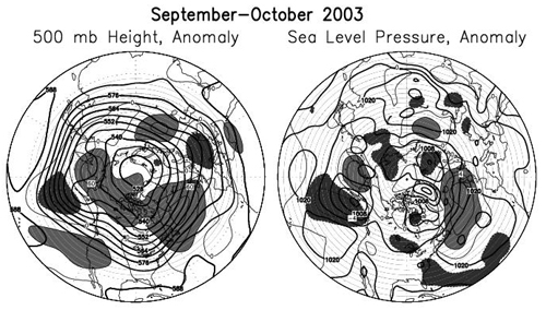
The early fall period was characterized by extensive areas of above normal mid-tropospheric heights, both at high and low latitudes of the western part of the Northern Hemisphere. The entire area from the Bering Sea eastward across northern Canada and the adjacent Arctic Basin, along with nearly all of the Atlantic Basin north of about 40 N, had higher than normal 500-hPa heights. Significantly below normal heights were limited to troughs over the eastern half of the Pacific and the eastern third of the continental U.S. The southwestern U.S. was dominated by an anomalously strong northeastward extension of the eastern Pacific subtropical ridge. This pattern was associated with a continuation of the long European drought into October, as the sea level pressure pattern was more anticyclonic than usual. The circulation over the Atlantic was unfavorable for the development of autumnal extratropical storms, but was associated with the continuation of a very active tropical storm season over the Atlantic - Caribbean Basin, with four named storms forming in September and three on October. Anomalous anticyclonic circulation at both the surface and aloft was especially strong during September and was centered near Newfoundland. This pattern prevented several of the tropical cyclones from recurving and steered them into areas not normally visited by hurricanes. The most notable was Isabel, which made landfall in North Carolina and severely impacted the entire Middle Atlantic region of the U.S. Even though it had already weakened considerably from the earlier Category 5 status that it held for close to five full days when over the tropical Atlantic, Isabel brought Category 2 winds near landfall in North Carolina and did widespread damage from Category 1 and tropical storm force winds, as well as from flooding due to both heavy rains and a large storm surge that went as far north as the upper Chesapeake Bay. Power outages took weeks to repair in some locations due to the large number of downed trees, caused by a combination of unusually wet ground following months of heavier than normal rainfall preceding the storm making it easier than usual to uproot trees, and the fact that there had not been a widespread strong wind event in the area for decades. Other unusual events related to tropical activity were the passage of Hurricane Fabian very close to Bermuda with extensive damage caused by 115 mph winds, and the landfall or Hurricane Juan near Halifax, Nova Scotia, where it was the most damaging tropical cyclone in decades.
The extensive tropical storm activity in these two months shows graphically on the mean sea level pressure map as a channel of below normal SLP over the southwestern Atlantic Basin. The ridge over the southwestern U.S., which remained strong well into October, was associated with a continuation of unusually hot and dry weather far into the fall, accompanied by a worsening of drought conditions and the prolongation of an already bad wildfire season. During October the middle tropospheric troughs over the eastern Pacific, northeastern U.S. and Europe all became considerably stronger than normal. Over the tropical Pacific, the El Nino/Southern Oscillation (ENSO) phenomenon continued in the neutral range, although most of the equatorial Sea Surface Temperatures were on the plus side of normal. The only sea surface temperatures (SST) capable of supporting widespread convection were centered near and just west of the date line, however, and all atmospheric indices use to monitor ENSO remained in neutral territory.
The eastern Pacific tropical cyclone season concluded in October, with 16 named storms, close to the normal total number. On the other hand, the same number of named storms in the Atlantic Basin represented a well above normal total there. With ENSO about neutral, other factors, such as an active summer rainy season and northward-displaced monsoon in West Africa, extensive areas of above normal SSTs, and deeper than normal easterly flow, all contributed to the very active and long Atlantic season, which began with the earliest named storm on record (Ana) in April, and ended with two late tropical storms (Odette and Peter) in December, after the official end of the season on 30 November.
November - December 2003
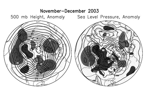
During the late fall and early winter months, the subtropical ridge over the Pacific was much stronger than normal and the westerlies and associated extratropical storm tracks were pushed north of their usual position. Moderately amplified troughs and cyclonic activity were found only over the extreme northwestern Pacific and the eastern part of the Pacific, near the U.S. west coast. Middle / tropospheric heights continued to average well above normal over the northwestern Atlantic, as well as over eastern Europe and western Russia, while heights were only slightly below normal over the eastern Atlantic and Mediterranean area. During November the eastern European ridge and eastern Atlantic trough couplet was the strongest anomaly, while in December the entire north Atlantic and northeastern Canada were covered by well above normal 500-hPa heights while conditions over Europe were not far from normal.
Generally below normal heights over western Canada and greater than normal southerly components in the mean flow over central Canada were unfavorable for the buildup of Arctic air until early December. During the first week of November, the Bermuda High built strongly over the southeastern U.S., and record high temperatures were observed at many locations in the eastern part of the country. It was not until early December that the first substantially colder than normal airmass and significant snow appeared over the northeastern U.S. in response to the increasing amount of blocking over the Davis Strait and northeastern Canada. Hudson Bay did not freeze over completely until late in December, considerably later than usual. The trough near the Pacific Coast became stronger and took on a negative (northwest to southeast) tilt in December, when it brought significantly above normal precipitation to most of the West Coast, especially to Oregon and northern California. By the end of the month, heavy rains reached southern California, where they caused extensive mudslides on slopes denuded of trees and vegetation by the wildfires a couple of months earlier. Over the equatorial Pacific, atmospheric and oceanic indices of the status of the El Nino/Southern Oscillation (ENSO) all remained within a neutral range throughout the two-month period. Warmest equatorial SSTs again remained near and west of the date line, and this was the only area of substantially enhanced convective activity, since SSTs, though above normal, were not high enough to support convection anywhere east of the dateline.
The author is the Senior Forecaster in the Forecast Operations Branch of the Climate Prediction Center /NCEP/NWS/NOAA. He participates in the preparation of all the types of forecasts done in the Branch: the 6-10 Day Extended Outlooks, Week Two Outlooks, Weekly Hazards Assessment, Monthly Outlooks, and the series of long-lead Seasonal Outlooks going out to a year ahead. Other duties of Mr. Wagner include applied research in developing tools for the various types of forecasts and giving special briefings on the forecasts and their methodology to the media and visiting scientists.
Page last modified: