Tropical Atlantic and Tropical East Pacific Areas September through December 2005
Daniel P. Brown, Tropical Analysis and Forecast Branch, Tropical Prediction Center, Miami, FloridaIntroduction
The September through December time period begins during the peak of the record setting 2005 Atlantic hurricane season. Therefore, the vast majority of the significant weather events of the period were active tropical cyclones that occurred across both the Atlantic and East Pacific basins. In the Atlantic, 15 of the record setting 27 named storms formed after 1 September, including 10 hurricanes. In the eastern Pacific, 6 of the 15 named storms formed after 1 September. During the period, gale warnings were issued in the TPC's Tropical Analysis and Forecast Branch (TAFB) Atlantic high seas forecasts on the incipient weather systems that became tropical storms Tammy, Gamma, Delta, and Zeta. (Due to the hyperactive hurricane season, the annual summary of the Atlantic and eastern Pacific hurricane seasons is not included in this edition of Mariner's Weather Log. It is expected to be published in the next edition.) Also as a result of the active hurricane season, TAFB's 2005 Atlantic High Seas Forecasts contained warnings 46% of the time. This was 15% higher than in 2004.
Atlantic
The first non-tropical gale warning of the fall and winter season did not occur until 14 November. Typically, the non-tropical gale season begins in the Gulf of Mexico and subtropical Atlantic in mid-to-late October. Between mid-November and the end of the December a few cold fronts produced gales in the Gulf of Mexico and the western Atlantic. A brief period of gales also occurred in the southern Caribbean along the coast of Colombia in mid-December.
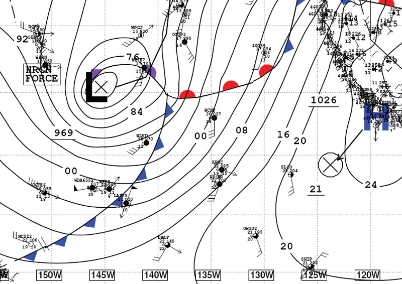
Figure 1. QuikSCAT data from around 1200 UTC 16 November, 2005.
Image Courtesy of National Environmental Satellite, Data, and Information Service
The most significant non-tropical event of the period brought storm force winds to the southwestern Gulf of Mexico between 16-18 November. This event began when a strong cold front moved off the Texas coast just before 0000 UTC 16 November. Behind the front, strong high pressure built southward. At 0000 UTC, a 1040 hPa (mb) high was analyzed over Idaho. The high covered the entire central and western United States. At 0600 UTC, the main high center remained over the northwestern United States, while a second 1034 hPA (mb) high was analyzed over northwest Texas. As this high built southward, it created a strong pressure gradient immediately behind the front over the Gulf of Mexico. Winds at NOAA buoy 42002 (25.2N 94.4W) quickly increased behind the front. Sustained winds at the buoy stayed just below gale force and peaked at 32 kts with gusts to 39 kts. Stronger winds occurred along the coast of Mexico, where the northerly winds funneled down the eastern slopes of the Sierra Madre Mountains. A QuikSCAT pass around 1200 UTC 16 November (Figure 1) detected 40-50 kts winds along the coast of Mexico. At some of the land based observing sites along the Mexican coast, 35 to 40 kts sustained winds were reported. At 1200 UTC 17 November, the 1035 hPa (mb) high was centered over eastern Texas. At this time, gale to storm force winds continued over the southwestern Gulf of Mexico. The front exited the southeast Gulf of Mexico early on the 18th. At this time, the high moved northeastward and weakened with gale force winds ending over the area. This event also produced storm force winds on the Pacific Ocean side of Mexico in the Gulf of Tehuantepec.
Eastern Pacific
The first Gulf of Tehuantepec gale event of the season began in early November. Once the "Tehuantepec season" began, the events occurred quite regularly from mid-November to late December. A total of six Gulf of Tehuantepec gale events occurred during the period. Storm force winds were observed during the event that occurred between 17 and 19 November. Table 1 is a list of the estimated beginning and ending times of Gulf of Tehuantepec gale and storm events during the period. These events were verified by either a reliable ship observation or timely QuikSCAT data.
| Gulf of Tehuantepec Gale and Storm Events September-December, 2005 |
||
|---|---|---|
| Event | Beginning | Ending |
| 1 | 1200 UTC 1 November | 1800 UTC 3 November |
| 2* | 0000 UTC 17 November | 0600 UTC 20 November |
| 3 | 0600 UTC 21 November | 1200 UTC 23 November |
| 4 | 0600 UTC 9 December | 0000 UTC 11 December |
| 5 | 0000 UTC 12 December | 1800 UTC 12 December |
| 6 | 0000 UTC 19 December | 0600 UTC 23 December |
| Table 1. Estimated beginning and ending times for Gulf of Tehuantepec gale and storm events from September through December, 2005. Storm event is denoted with an asterisk (*). | ||
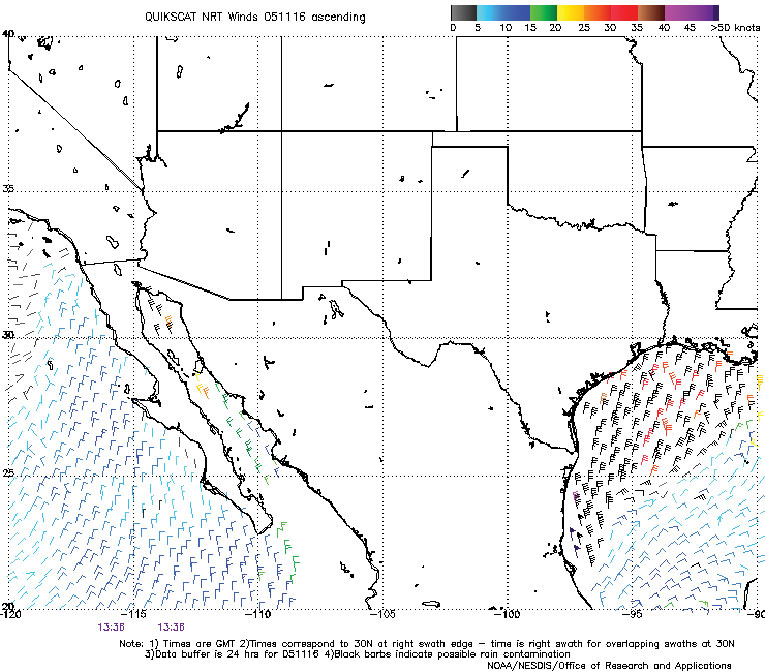
Figure 2. National Weather Service Unified Surface Map Analysis at 1200 UTC 19 December. Solid lines are isobars at 4-hPa (mb)
interval. Note, the TAFB northeast Pacific high seas forecast area extends from the equator to 30N, east of 140W to the coast of Mexico and Central America.
The most significant non-Tehuantepec event of the period occurred between 18 and 20 December. During this event, two very strong lows produced an extended period of gale force winds. The first low, 986 hPa (mb), moved east-northeastward near the northwestern portion of the TAFB high seas area (from the equator to 30N, east of 140W to the coast of Mexico and Central America). This low produced an area of 30-40 kts southwesterly winds on the 18th. A second, much stronger low centered about 1200 nmi north-northeast of the Hawaiian Islands at 0000 UTC 19 December moved east-northeastward and rapidly deepened. This low was unusually strong for such low latitudes in the northeastern Pacific Ocean. By 1200 UTC, the 969 hPa (mb) low was centered near 36N 146W, about 350 nmi northwest of the TAFB high seas forecast area. Around 1200 UTC (Figure 2), the trailing cold front crossed 140W south of 30N. Immediately ahead of the front, winds increased to storm force. At 1800 UTC the ship, Nikkei Tiger (3FMH7), observed 55 kts winds near 28N 137W. Another ship, the Greenwich Maersk (MZIF7) also reported 55 kts winds near 32N 136W at 0000 UTC 20 December. Seas built to 8.5 to 12 m (28 to 40 ft) near 30N 140W (the northwestern corner of TAFB's area of responsibility). Later on the 20th, the low turned north-northeastward and moved northward away from the area. Winds decreased below storm force south of 30N by 0600 UTC and dropped below gale force by 1800 UTC.