The Importance of Weather Observations On Board Ships - The Experience of AS VICTORIA
-Submitted by: Horst von Bargen, Deutscher Wetterdiens - Hamburg, DE
Horst.Bargen-von@dwd.de
-Written by: J. Jansen, C. Lefebvre

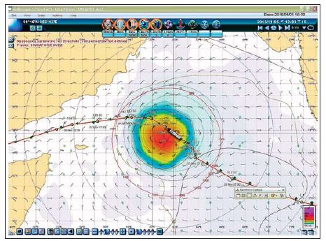
Figure 1: Weather conditions and position and way of AS VICTORIA, 6 November, 12 UTC (Source: AS Victoria)
Weather observations and measurements are regularly undertaken by the Voluntary Observing Ships (VOS). Their importance was recently recognized by an award given to the crew of the AS VICTORIA, which belongs to the shipping company,Ahrenkiel Steamship Group, Hamburg Germany. In April 2016 it received a certificate of "Recognition of Special Service" of the India Meteorological Department (IMD) in appreciation of their contribution to marine safety and public welfare through their special weather observations from the area of the tropical cyclone MEGH, November 2015. The India Meteorological Department has been designated as Regional Specialized Meteorological Centre (RSMC) New Delhi; which is responsible for the monitoring and prediction of cyclonic storms in the Arabian Sea and the Bay of Bengal. The weather observations produced by the AS VICTORIA improved the analysis of Tropical Cyclone MEGH and lead to an improvement of the prediction of the future course of the storm, from which the crew of the AS VICTORIA benefited from later.
The Development of MEGH along the Route of the AS VICTORIA
On November 4, while AS VICTORIA was on her way from Singapore to Suez, she continuously observed and reported the weather conditions. At the same time a tropical low developed over the Arabian Sea around 14 N and 67 E. A positive Indian Ocean Dipole (IOD) (see information box) provided sea surface temperatures (SST) above 29 °C and low vertical wind shear provided favorable atmospheric conditions for intensification. MEGH intensified into a tropical storm on November 5th while moving westward. (Distance to the ship about 250 nm at 12 UTC).
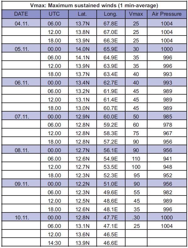
Although dry air was being entrained into the circulation, the storm continued to intensify on November 6th. It developed into a small system with a convective core of 150 nm in diameter and a well-developed pinhole eye. On November 6th, AS VICTORIA crossed the track of MEGH with the intention to approach the NE-sector to use favorable winds and to overtake the cyclone. At 12 UTC the vessel was positioned only 38 nm from the center (Figure. 1) and reported wind speeds of Beaufort wind 8 from SSE and a wave height of 1.5 m (Figure. 2). The maximum wind near the eye at this time was 45 kts (Beaufort wind 9) (Table. 1). AS VICTORIA succeeded in reaching an appropriate location to the north resp. north-west, in the following of Tropical Cyclone MEGH, which continued to intensify. On November 7th, MEGH increased to hurricane force and on the 8th it reached peak intensity with maximum wind speeds up to 110 kts for a period of 3 hours (06 - 09 UTC).

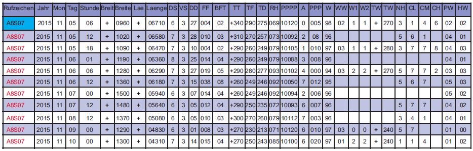
Figure 2: Weather observations by AS Victoria received at DWD (Source: DWD)

Table 1: Re-analysis by the Naval Research Laboratory (NRL), Monterey CA. (Institution of Joint (U.S. Air Force and Navy) Typhoon Warning Centre (JTWC))

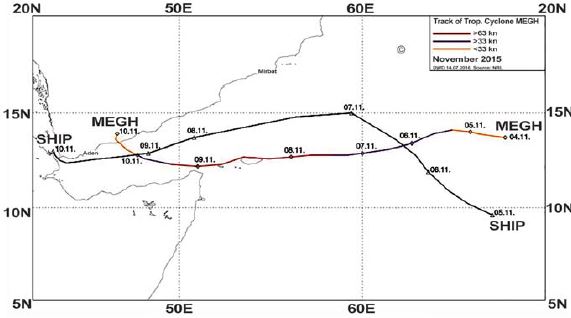
Figure 3: Track of Tropical Cyclone MEGH and the way of AS Victoria (Source: DWD)
The radius of hurricane-force winds was about 15 nm, gale-force winds 40 to 45 nm. Meanwhile the distance of AS VICTORIA to the storm center had increased to more than 160 nm. During this time the eye of MEGH had started to cross the northern coast of Socotra and the interaction with land weakened the cyclone (Figure. 3). Continuing its westward movement MEGH weakened further over the Gulf of Aden due to cooler SST, the entrainment of dry air, and land interaction over the Arabian Peninsula and Somalia. On November 10th, the system now downgraded to a depression, made landfall in Yemen.
The average forward speed during the entire life cycle was 8 - 9 kts; on the 8th and 9th, however, MEGH moved at a speed of 10 - 12 kts.
Why are Observations by Ships Still Essential in the Era of Weather Satellites?
Meteorological satellites (geostationary at an altitude of about 36.000 km and sun-synchronous at a height of about 850 km) provide images and data in numerous spectral ranges. Their advantage is the generation of region-wide measurements. They allow us to receive information also from areas where there are no weather stations.
The parameters are not measured directly, but are derived from electromagnetic radiation of the Earth's surface, the atmosphere as well as from reflected signals emitted from radar and sonar instruments by applying extensive computational procedures. By combining several spectral ranges, a variety of meteorological parameters may be derived. This enables us to obtain information about the atmospheric properties and phenomena such as clouds and precipitation, but also about oceanographic surface parameters like sea surface temperature and wind speed. But it is not always possible to derive all parameters. Heavy rain e.g. impedes the view of the sea surface and therefore the derivation of the wind speed from wave characteristics. Above all, the direct measurement of air pressure from space is not feasible. Ship observations are used as a ground-based reference to calibrate measurements from satellites and the applied algorithms and to evaluate their correctness.
Surface-based measurements e.g. onboard of ships are indispensable for weather analysis and prediction as well as for long-term climate analysis. Therefore, ship observations provide an essential contribution - not just in individual cases - to the safety at sea.
J. Jansen, C. Lefebvre
Info-Box:
The Indian Ocean Dipole (IOD) , also known as the Indian El Nino, is an irregular oscillation of sea-surface temperatures in which the western Indian Ocean becomes alternately warmer and then colder than the eastern part of the ocean.
Back to top