Tropical Atlantic and Tropical East Pacific Areas May through August 2015
Jorge Aguirre-Echevarria and Dan Mundell
Tropical Analysis and Forecast Branch,
National Hurricane Center, Miami, Florida
NOAA National Center for Environmental Prediction
Atlantic Ocean including the Caribbean Sea and the Gulf of Mexico
There were Twenty-Seven (27) non-tropical cyclone gale events that occurred between 1 May and 31 August 2015 in the area of high seas forecast responsibility (7oN to 31oN, west of 35oW including the Caribbean Sea and Gulf of Mexico) of the National Hurricane Centers (NHC) Tropical Analysis and Forecast Branch (TAFB). The Caribbean Sea had Twenty-Three (23) of these events making it the busiest of the basins in recent years for this time period.

Pre-Bill Caribbean/Gulf of Mexico Gale Event
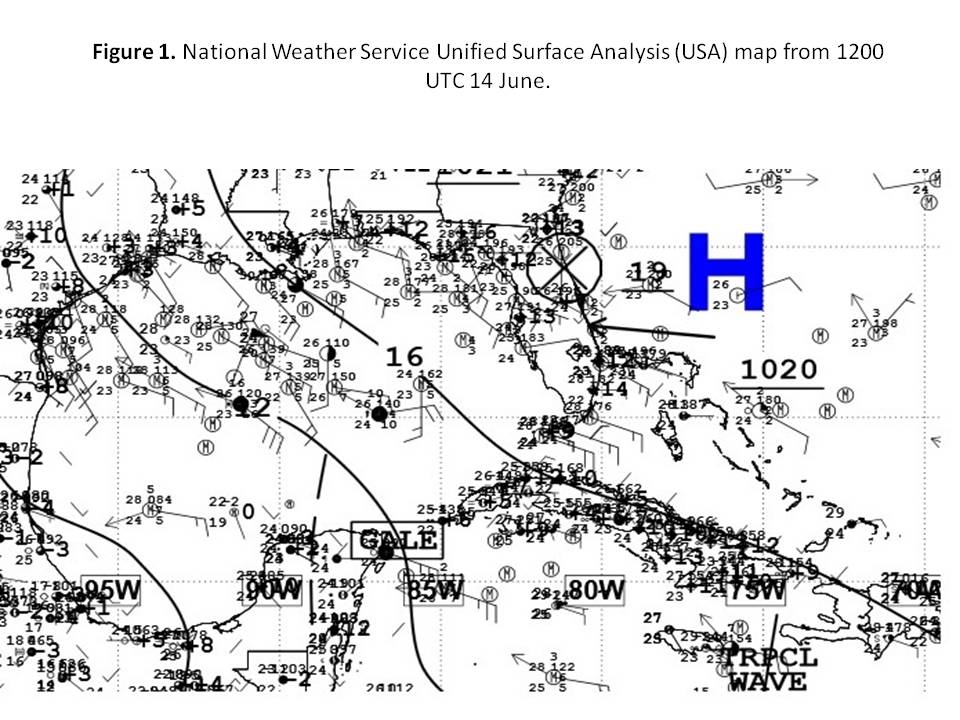
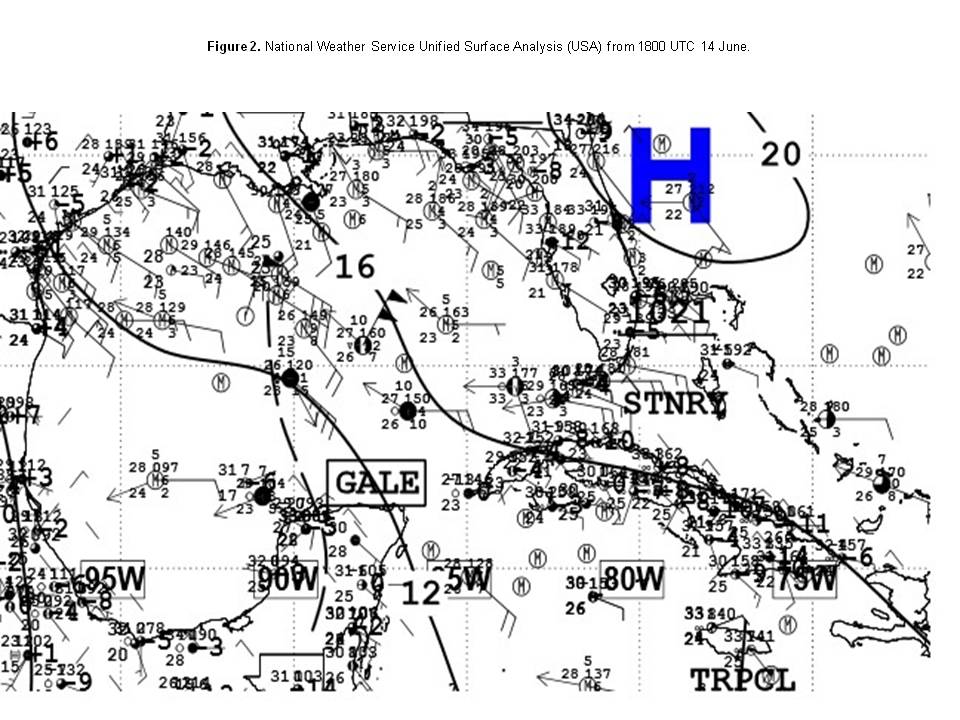
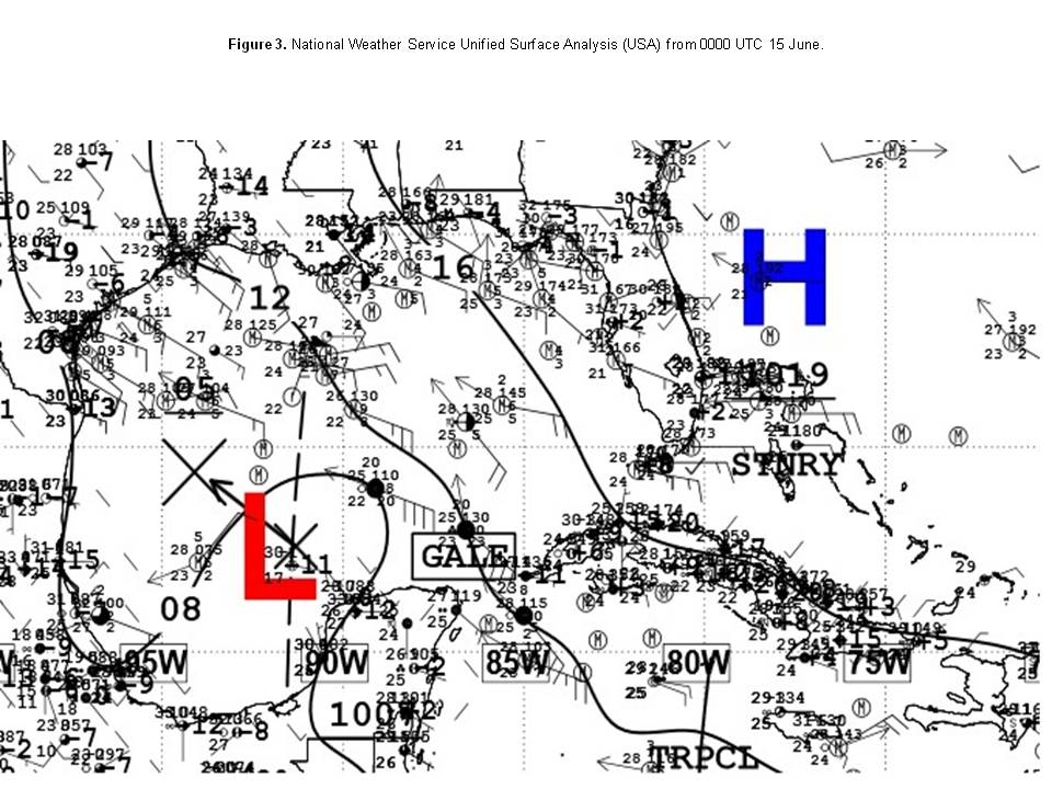
A gale event occurred over a portion of the Caribbean Sea in an area where these events are considered rare, especially during the summer months. A surface trough moving westward through the northwest Caribbean Sea on the morning of 14 June began to interact with Atlantic high pressure of 1020-1021 hPa located near the northwest Bahamas. (Figure 1) A tight isobaric spacing between the 1012 hPa and 1016 hPa isobars induced southeast gale force winds of 25 to 35 kts in the northwest Caribbean area from 19N to 22N between 85W and 87W that morning. The trough continued westward across the Yucatan Peninsula, and into the south central Gulf of Mexico during the afternoon of that same day as broad low pressure began to take shape over the northern Yucatan Peninsula. This shifted the gale force winds to along the northern Yucatan Peninsula and adjacent waters. (Figure 2) By 00 UTC 15 June, a surface low had developed along the trough over the eastern portion of the southwest Gulf of Mexico with east to southeast gale winds over portions of the south central Gulf of Mexico, including Yucatan Channel vicinity waters. (Figure 3) This low eventually developed into Tropical Storm Bill over the northwest Gulf of Mexico late on the evening of 14 June.
Other Caribbean Gale Events
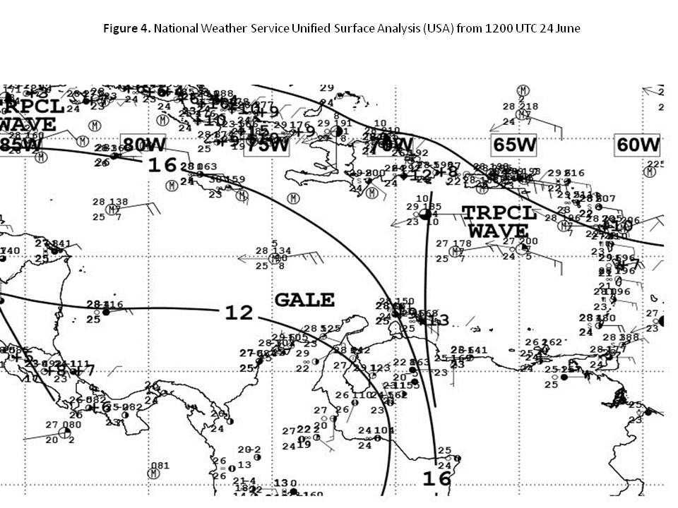
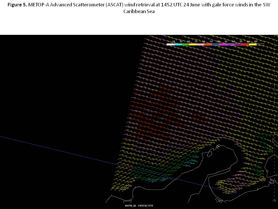
There were Twenty-Three (23) gale events in the Southwest Caribbean Sea between May 1 and August 31. The longest in duration occurred from 06 UTC 24 June to 12 UTC 27 June in the favorable climatological area of strongest trade winds found over a portion of the SW Caribbean Sea to the coasts of Colombia and northwestern Venezuela. This particular event was confined from 11N to 15N between 72W and 75W. The combination of a very tight pressure gradient between broad Atlantic high pressure ridging with axis roughly along 28N/29N, and low pressure across the Colombian basin along with the added reinforcement to the gradient due to passage of tropical waves initiated NE to E 30 to 40 kts winds with seas of 13 to 14 ft across that part of the SW Caribbean. (Figure 4)
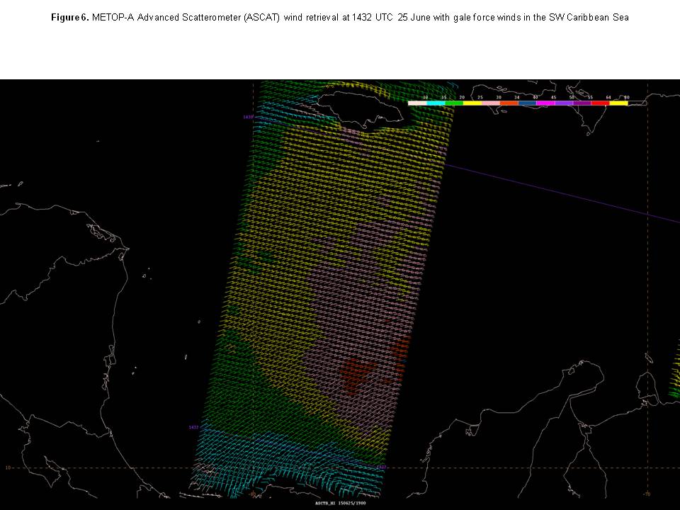
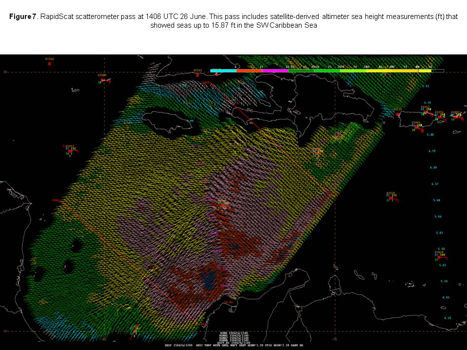
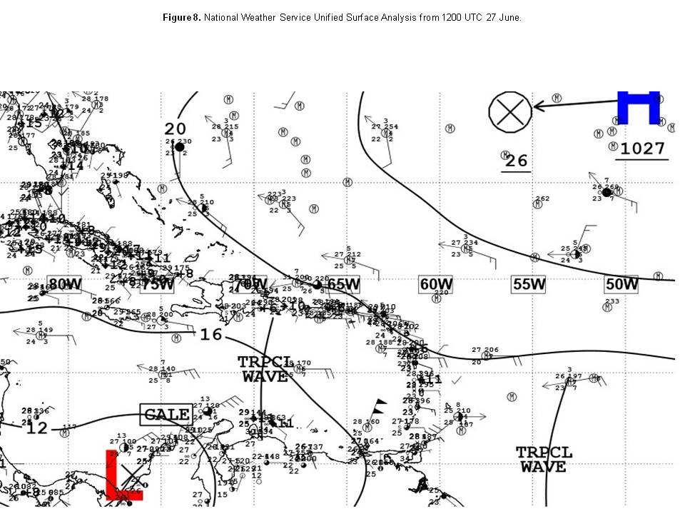
National Data Buoy Center (NDBC) Buoy 42058 at 15N78W recorded similar wave height values. (Figure 5). Observations from ship STAR LIVORNO (LAQM7) reported northeast winds of 35 kts at 00 UTC 25 July at location 19N68W and 36 kts at 12 UTC 25 July at location 17N67W (Figure 6). Further proof of the ongoing gale event was noted in a RapidScat pass from the morning of June 26 that clearly showed the gale force winds (Figure 7). On 27 June ship MAERSK DAYTON (DDSC2) reported 40 kts at 12 UTC near location 13N73W (Figure 8).
Note the tight gradient near the coast of Colombia with the approaching tropical wave. The culprit pressure gradient of this gale event weakened just enough to allow for the gale winds to diminish just below gale force soon after 12 UTC on 27 June.
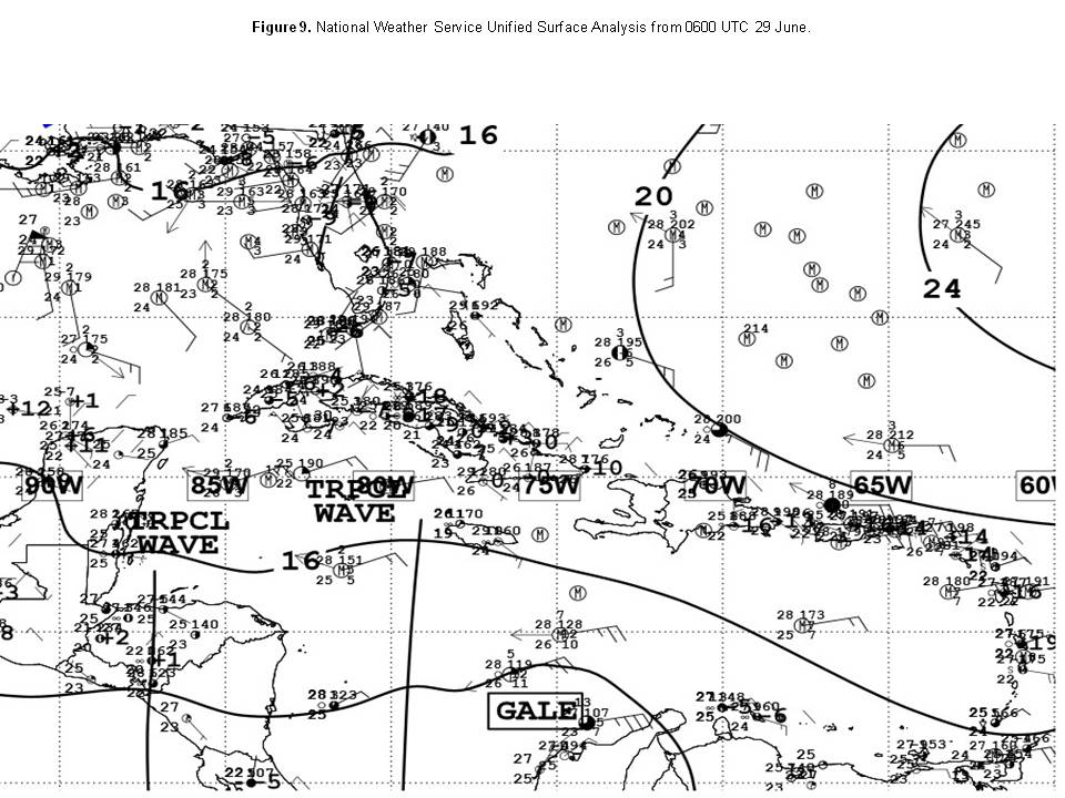
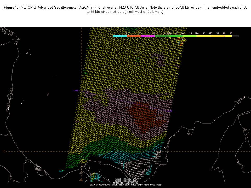
The event that started at 06 UTC 29 June lasted for 18 hours. An observation from ship ESMERALDA (CCES) indicated east winds of 35 kts at 06 UTC on 29 June near 12N74W. Interestingly, this ship is registered with the Chilean military, and was sailing east-northeast near the coast of Colombia at that time possibly on a training mission (Figure 9). The tight pressure gradient over much of the SW Caribbean Sea was further enhanced by passage of a quick moving tropical wave. Note the observation from ship ESMERALDA (CCES) with 35 kts winds located just to the southeast of the GALE text label on the map). The event that started at 00 UTC 30 June was nicely captured by an ASCAT scatterometer pass that morning (Figure 10). During the event that began on 29 July at 00 UTC ship BRITISH MERLIN (VQOG5) reported northeast winds of 40 kts at 12 UTC on 29 July near 12N75W. The remaining gale events occurred under a similar synoptic scale pattern as described above.
Pre-Ana Gale Event
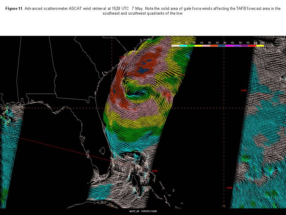
Low pressure of 1004 mb near 31N77W on the morning of 7 May was accompanied by gale force winds of 25 to 35 kts within 60 nmi of the low in the southwest quadrant with seas in the range of 8 to 11 ft range (Figure 11).
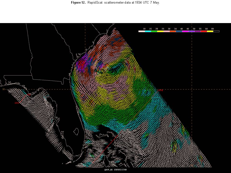
These winds were also captured by Air Force Hunter aircraft that same morning. By 1800 UTC that same day the gale force winds had expanded to within 90 nmi of the low in the southwest quadrant, and within 60 nmi in the southeast quadrant revealed in a RapidScat pass from thatafternoon (Figure 12).
The low was classified as subtropical Storm Ana at 03 UTC 8 May near 31.5N77.6W or 170 nmi south-southeast of Myrtle Beach South Carolina.
Post-Erika Gale Event
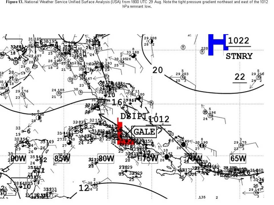
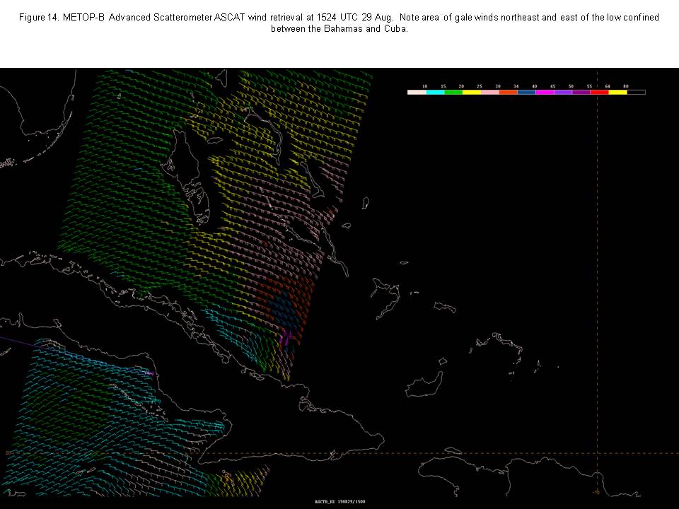
On the morning of 29 August, Tropical Storm Erika degenerated to a remnant low near the eastern coast of Cuba, and continued on a west-northwestward motion along the central coast of Cuba during that afternoon. The synoptic pattern that day featured a 1022 hPa high pressure center well to the northeast of the low (Figure 13). The tight pressure gradient between the high center and the remnant low intitiated gale force winds of 30 to 35 kts within 90 nmi in the northeast quadrant, and 120 nmi in the east quadrant of the low with seas of 9 to 12 ft. ASCAT scatterometer data from that morning confirmed the gale force winds prompting the issuance of a gale warning (Figure 14).
The gale force winds were also confirmed from reports from an Air Force Reserve Hunter aircraft flying in the area of the low. The low weakened to a trough near the coast of central Cuba by 00 UTC 30 August with an area of gale force winds roughly from 22N to 24N between 76.5W and 78W. By 0600 UTC 30 August, the trough was along 81W from 21N to 25N with associated winds having diminshed to just below gale force.
Eastern North Pacific Ocean
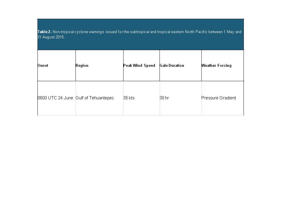
One significant warning event (not associated with tropical cyclones) was documented by scatterometer data in the May through August 2015 time period. Table 2 provides details on the gale wind event.
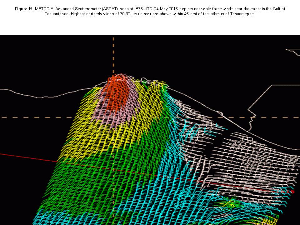
Strong high pressure in the northern Gulf of Mexico and low pressure associated with the monsoon trough south of Central America created a tight pressure gradient across southern Mexico in late June. GFS global model forecasts indicated local effects would allow peak 10 meter winds in the Gulf of Tehuantepec to reach 35 kts around sunrise on the mornings of June 24th and 25th, for which a gale warning was issued 18 hours prior to the expected onset of the high wind event. ASCAT scatterometer passes at 0308 UTC and 1538 UTC on 24 June revealed 30-32 kts winds extending downwind from the Isthmus of Tehuantepec. (Figure 15) Winds in excess of 34 kts were likely between the overpass times from 0600 to 1200 UTC. No scatterometer data was available in the Gulf of Tehuantepec the morning of June 25th, and no ships were reported passing through the region of gale force winds. In addition, gale or storm warnings were issued on four tropical low pressure systems which eventually became tropical cyclones, a summary of which is included in the next paragraph.
This represented a minor change in policy at the Tropical Analysis and Forecast Branch (TAFB). In previous tropical cyclone seasons, forecasters refrained from issuing gale and/or storm warnings for closed lows which the global forecast models developed into tropical cyclones within 48 hours, reflecting a general lack of confidence in the various global forecast models to accurately predict the onset of winds in excess of 33 kts for developing tropical lows, thus preferring to wait for the Hurricane Specialist Unit (HSU) to initiate advisories before issuing marine warnings. But recent advances in the ability of forecast models to predict cyclogenesis with greater accuracy has allowed TAFB to take a less restrained approach to marine warnings prior to the first tropical cyclone advisory, as long as there is a very high likelihood of cyclogenesis. Summary of warnings associated with tropical cyclones: A storm warning was issued at 2100 UTC 19 July on a low pressure system with very high potential of becoming a tropical cyclone and forecast models showing winds in excess of 50 kts within 48 hours. The low failed to intensify beyond 30 kts for several days, and the warning was downgraded to a gale 24 hours later, then discontinued altogether at 1200 UTC 22 July. The low eventually consolidated into a tropical cyclone and was named Tropical Storm Felicia at 1500 UTC 23 July. A storm warning was issued at 2100 UTC 29 July for the circulation which was subsequently upgraded to Tropical Storm Guillermo 12 hours later. A gale warning was issued at 1500 UTC 14 Aug for the circulation which became Tropical Depression Eleven-E 36 hours later, and a gale warning was issued at 1500 UTC 26 Aug for the low that became Jimena 12 hours later. A full description of the evolution of these lows from their initial stages up to the point where advisories were initiated is in the tropical cyclone section of this publication.
Back to top