Tropical Atlantic and Tropical East Pacific Areas May through August 2014
Jorge Aguirre-Echevarria and Dan Mundell Tropical Analysis and Forecast Branch National Hurricane Center, Miami, Florida NOAA National Center for Environmental Prediction
Atlantic Ocean including the Caribbean Sea and the Gulf of Mexico
There were six (6) non-tropical cyclone gale events that occurred between 1 May and 31 August 2014 in the area of high seas forecast responsibility (7oN to 31oN, west of 35oW including the Caribbean Sea and Gulf of Mexico) of the National Hurricane Centers (NHC) Tropical Analysis and Forecast Branch (TAFB). This was relatively quiet compared to the average activity of the last 5-10 years for the May through August period, but busier in the Caribbean Sea compared to last year.

Gulf of Mexico Gale Warning
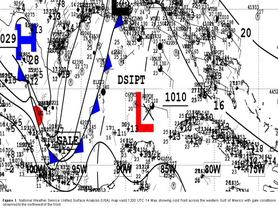
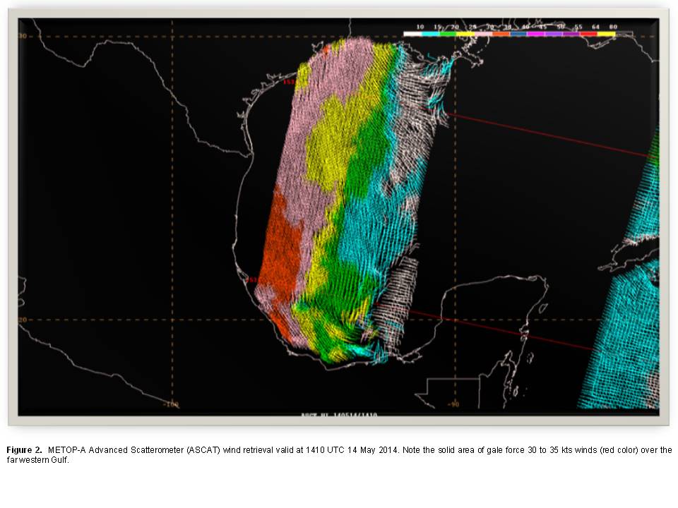
The gale event with the longest duration during this time period occurred from 14 to 15 May in the Gulf of Mexico behind an unusually strong late season cold front. The cold front moved over the warm Gulf of Mexico sea surface temperatures ( SST) followed by cold air advection as strong high pressure anchored by a 1029 mb high over northern Mexico built southward across the region. The cold front reached from a 1014 mb low over southeast Louisiana to inland Mexico just south of Veracruz Mexico at 1200 UTC 14 May (Figure 1- National Weather Service Unified Surface Analysis (USA) map from 1200 UTC 14 May showing cold front across the western Gulf of Mexico with gale conditions observed to the northwest of the front ). A gale warning was issued at 1200 UTC 14 May for areas behind the front as the cold air advection over the warm sea surface temperatures led to boundary layer instability resulting in NW to N gale force winds in the range of 25 to 35 kts. (Figure 2 - METOP-A Advanced Scatterometer ( ASCAT) wind retrieval at 1534 UTC 14 May. Note the solid area of minimal gale force winds (red color) over the far western Gulf surrounded by a large area of 20 to 30 kts winds). The high pressure weakened throughout the remainder of the 14th, and into the next day of May 15th allowing the tight pressure gradient behind the front to slacken. As a consequence, the winds diminished to below gale threshold by 1800 UTC on 15 May.
Pre-Cristobal Gale Event
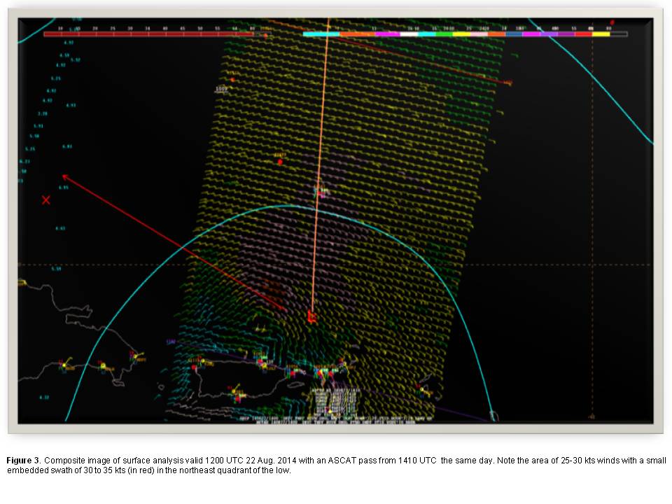
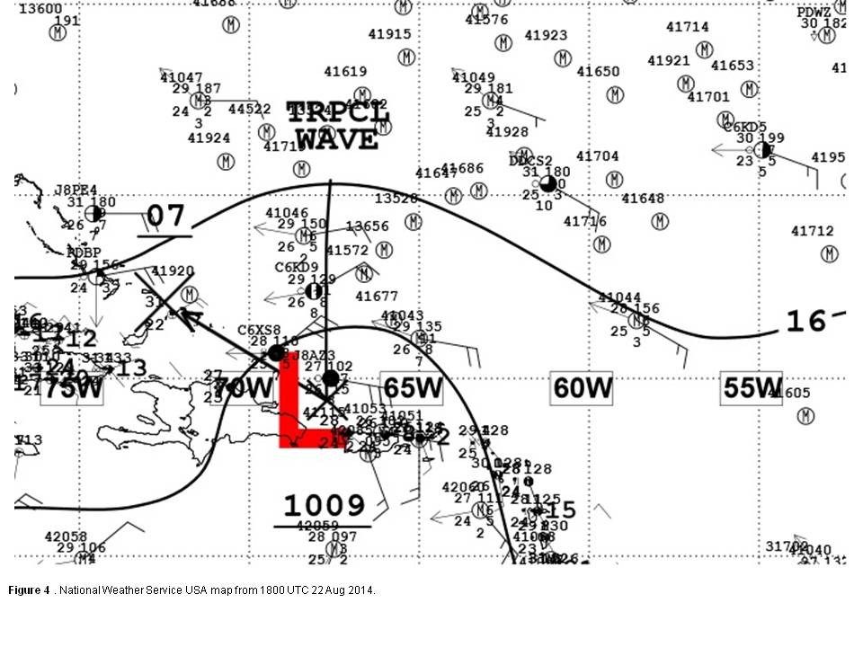
A tropical wave was analyzed near 65W with low pressure of 1009 hPa just northeast of Puerto Rico and the Virgin Islands near 19N65W at 1200 UTC 22 Aug (Figure 3 - Composite image of surface analysis valid 1200 UTC 22 Aug with an ASCAT pass from 1410 UTC the same day. Note the area of 25 to 30 kts winds with a small embedded swath of 30 to 35 kts, in red, in the northeast quadrant of the low). A tight pressure gradient between these features and a surface ridge to their north roughly along 28N produced an area of east to southeast 30 to 35 kts winds within 90 nm of the low center in the northeast quadrant. The cruise ship ALLURE OF THE SEAS (call sign C6XS8) reported northeast winds near 35 kts just northwest of the low at 1800 UTC on 22 Aug, while the ship TROPIC TIDE (call sign J8AZ3) reported similar winds from the east to southeast at the same time (Figure 4 - National Weather Service USA map from 1800 UTC Aug 22). This system was eventually classified as Tropical Depression Four on 23 Aug.
Caribbean Gale Events
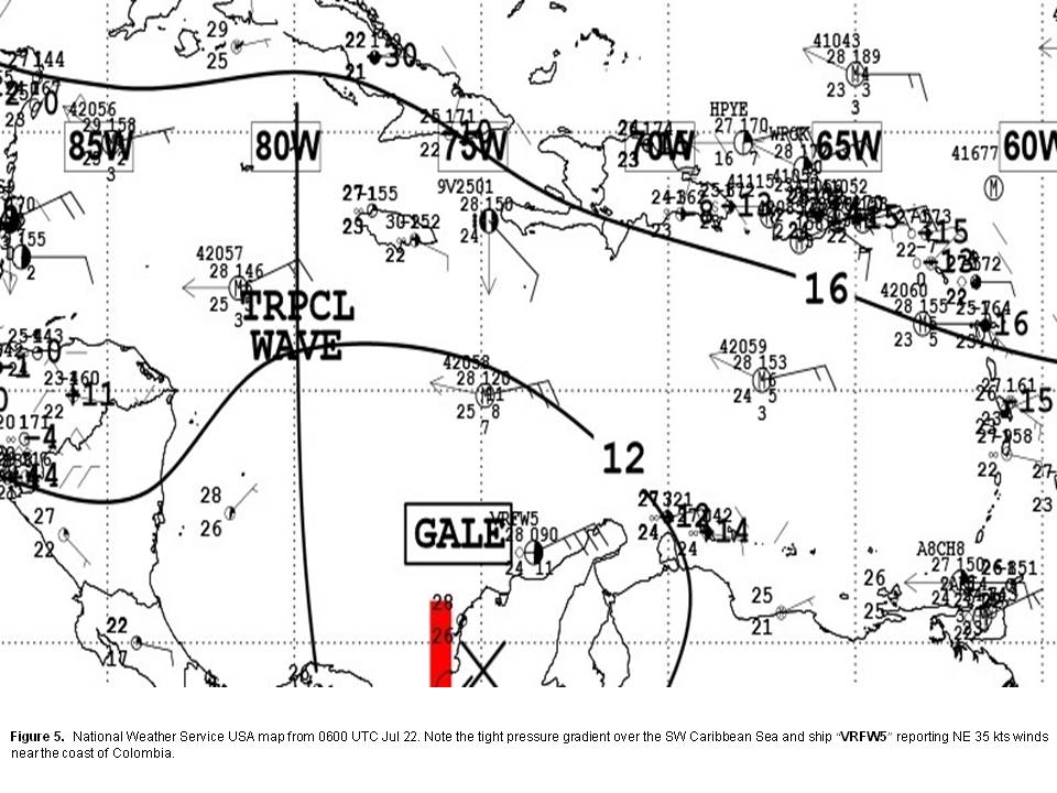
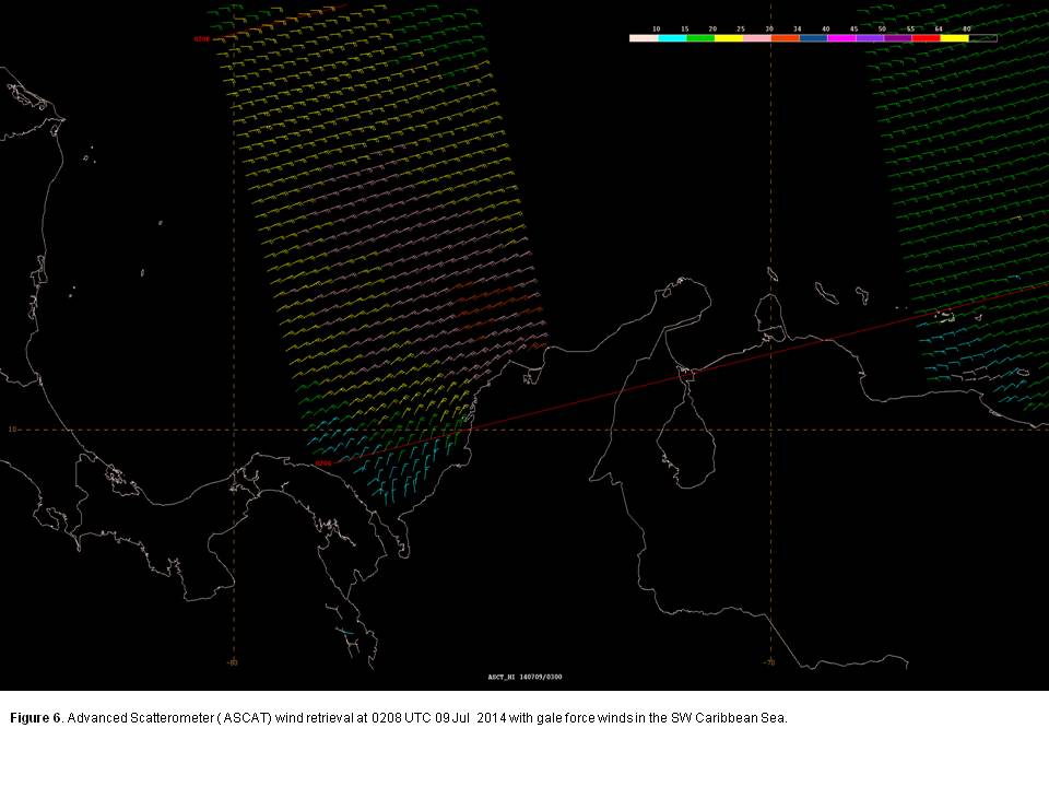
There were four gale events in the Southwest Caribbean Sea with the longest duration occurring from 0600 UTC 22 July to 1200 UTC 23 July in the favorable climatological area of strongest trade winds found in the southwest sector of the Caribbean Sea south of 14N to the coasts of Colombia and northwestern Venezuela. This particular event was confined to between 72W and 75W. The tight pressure gradient between a subtropical ridge to the north over the Atlantic and low pressure across the Colombian basin initiated NE to E 30 to 35 kts winds with seas to 12 ft across the region. An observation from the HAZMAT ship MAERSK NITEROI (call sign VRFW5) located near the coast of Colombia reported northeast winds of 35 kts at 0600 UTC 22 Jul. This observation was used to verify the gale warning in effect. (Figure 5 National Weather Service USA map from 0600 UTC 22 Jul. Note the tight pressure gradient over the SW Caribbean Sea and MAERSK NITEROI (call sign VRFW5) reporting NE 35 kts winds near the coast of Colombia ). Winds diminished to below gale force just after 1200 UTC on 23 Jul as the tight pressure gradient weakened. The remaining gale events in the May to August period occurred under a similar synoptic scale pattern. These events were of 12 hour duration with one beginning on 13 Jun at 0600 UTC and lasting to 1800 UTC that same day. Similarly, the remaining two began on 25 Jun at 0600 UTC and at 0600 UTC on 09 Jul. (Figure 6 - Advanced Scatterometer (ASCAT) wind retrieval at 0208 UTC 09 Jul 2014 with minimal gale force winds in the SW Caribbean Sea).
Eastern North Pacific Ocean
Three significant warning events not associated with tropical cyclones were documented primarily by scatterometer data in the May through August 2014 time period. Table 2 provides details on these gale wind events.

Gale warnings were issued for two circulations which were subsequently upgraded to tropical storms six hours later, Elida at 0600 UTC Jun 30, and Fausto a week later at 1800 UTC Jul 7.
The first half of May was an extension of an unusually strong winter and early spring season in 2013-14, which was the most active for gale and storm force gap wind events in the Gulf of Tehuantepec ever recorded. There were a total of thirty-three (33) Gulf of Tehuantepec high wind events this season, which shattered the previous record of twenty-four (24) which occurred in the 2003-04 and 2011-12 seasons.
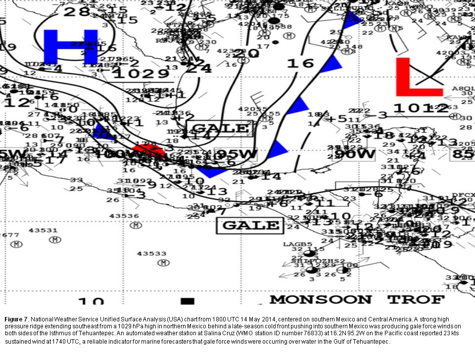
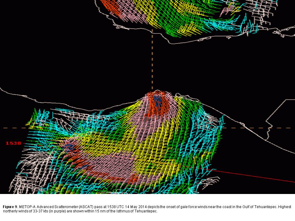
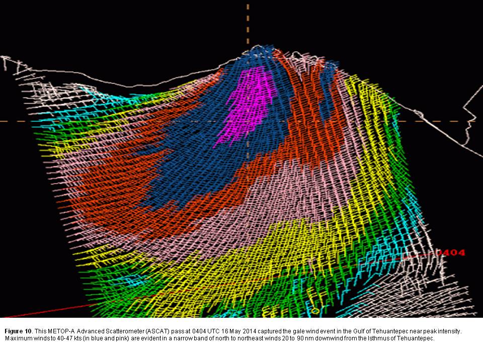
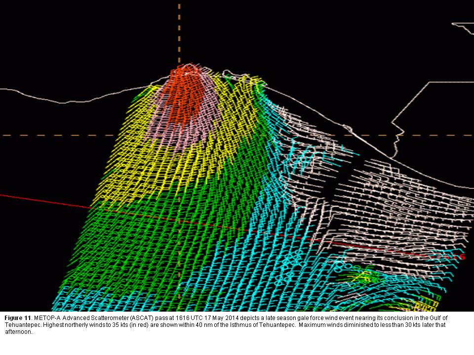
Late season Gulf of Tehuantepec wind events are typically initiated by strong northerly winds behind a cold front across the western Gulf of Mexico. This strong flow advects cold air southward, and funneling effects are most pronounced across the Isthmus of Tehuantepec. This was the case for both gale warnings issued for the Gulf of Tehuantepec in May 2014. The more significant of these two events commenced around 1500 UTC May 14th. It was significant for three reasons. First, it occurred much later than usual, more than two weeks after the climatological end of the Gulf of Tehuantepec high wind season in late April. Second, it was also very intense, with maximum winds approaching storm force. This is rare for a late season event. Lastly, it was of unusually long duration, with scatterometer data showing winds exceeding gale force for more than three days.
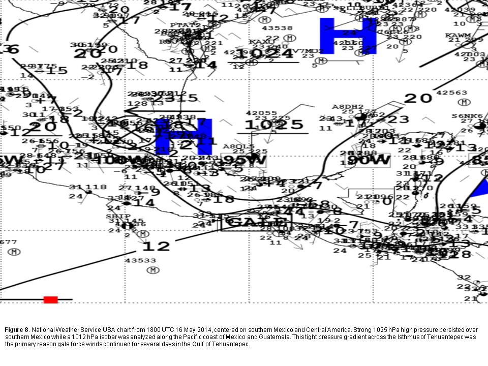
Strong high pressure behind a cold front reaching the Bay of Campeche in the Gulf of Mexico and a broad monsoon trough across the eastern North Pacific produced a tight pressure gradient across southern Mexico resulting in gale force northerly winds, both in the southern Gulf of Mexico early on the morning of May 14th, then later that day in the Gulf of Tehuantepec. (Figure 7). High pressure behind the front persisted over southern Mexico through the evening of May 16th (Figure 8) before slowly shifting eastward and weakening. As a result, a very tight pressure gradient remained across the Tehuantepec region for several days, supporting gale force winds from 1500 UTC on May 14 until finally coming to an end at 1800 UTC May 17.
A series of METOP-A Advanced Scatterometer (ASCAT) scatterometer passes over the area were able to capture this high wind event from its onset through peak winds on the morning of May 15th until the weakening phase. Forecasters expected the gale to begin around 1800 UTC on May 14th but an ASCAT pass at 1538 UTC showed the high winds were already occurring, which prompted TAFB to amend its High Seas forecast at 1805 UTC to indicate a gale warning was in effect (Figure 9). Peak winds of 40 to 47 kts were measured by an ACSCAT pass at 0404 UTC May 16 (Figure 10). Forecasters expected the high wind event to conclude Saturday morning May 17, but an ASCAT pass at 1616 UTC confirmed a small area of 35 kts was still present (Figure 11) so the gale warning was allowed to continue another six hours, and expired at 0000 UTC May 18.
Several ships in the vicinity of the Gulf of Tehuantepec during this time period also provided marine observations. The cargo vessel STAR HARMONIA (call sign LAGB5) reported 37 kts at 1200 UTC May 15 near 14.3N 95.5W, and the cargo vessel CAP PALLISTER (call sign A8O84) reported 38 kts with 14 ft seas at 2100 UTC May 16 near 15.0N 94.6W. Both observations were used to verify the gale warning in effect.
Back to top