Mean Circulation Highlights and Climate Anomalies January through April 2014
Anthony Artusa, Meteorologist, Climate Operations Branch, Climate Prediction Center NCEP/NWS/NOAA
January-February 2014
All anomalies reflect departures from the 1981-2010 base period.
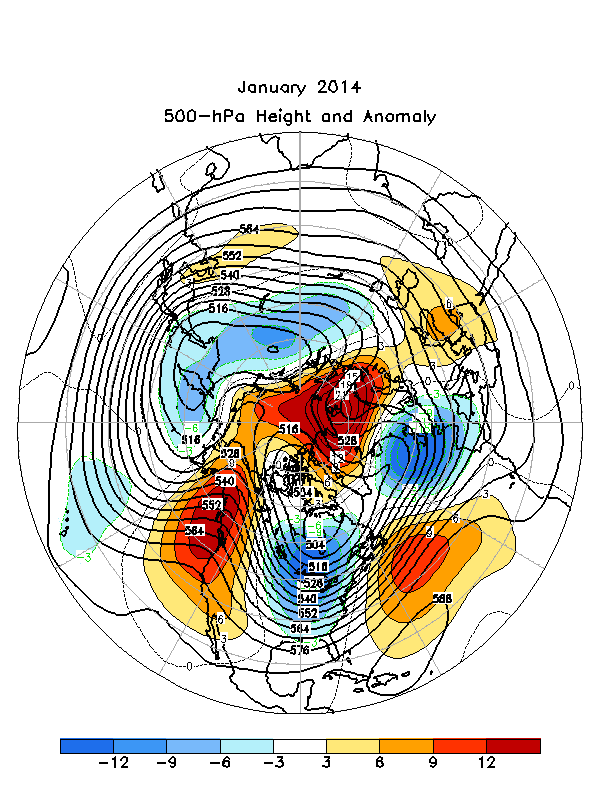
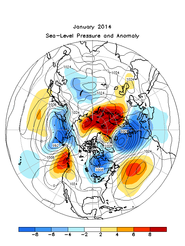
The mid-tropospheric circulation during January featured a persistent zonal wave 2 pattern. This pattern included a strong ridge in western North America and another over most of Greenland and Scandinavia. It also included a moderately strong trough which extended from central Asia to the eastern North Pacific, and another extending from the eastern contiguous U.S. across far southern Greenland to Europe Figure 1. The sea level pressure (SLP) pattern broadly resembles the 500 hPa pattern, with several key features being the Aleutian and Icelandic Lows Figure 2.
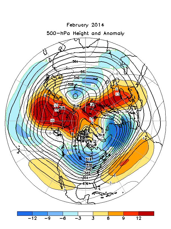
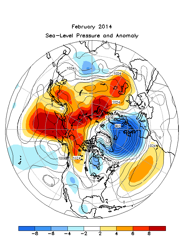
The 500 hPa circulation during February featured above average heights over much of the western North Pacific, the central North Atlantic, and western Russia, and below average heights across much of North America, the high latitudes of the North Atlantic, and central Russia Figure 3. As was the case with January, the February SLP pattern broadly resembled its corresponding 500 hPa pattern, with an unusually deep Icelandic low again being a major feature of the monthly climate Figure 4.
According to the National Climatic Data Center, many locations throughout the Midwest experienced their top 10 coldest winter, while Detroit had its snowiest winter on record. Persistent cold during winter caused 91 percent of the Great Lakes to be frozen by early March, the second largest ice cover on record. In contrast, California had its warmest and third driest winter on record, very low snowpack, and large precipitation deficits. Reference 1
The Tropics
Sea surface temperatures (SSTs) remained near average across the central and eastern equatorial Pacific in January and below average across the eastern Pacific in February. The latest monthly Nino index for the Nino 3.4 region was -0.5C (January) and -0.6C (February). The depth of the oceanic thermocline (measured by the depth of the 20C isotherm) remained close to average across the central and east-central equatorial Pacific (January), and slightly below average across the eastern Pacific (February).
Equatorial low level easterly trade winds remained near average across the central and eastern equatorial Pacific in both January and February, and below average over the western Pacific (February). Tropical convection remained enhanced over the western Pacific, and suppressed over the central equatorial Pacific and western Indonesia (February). Collectively, these oceanic and atmospheric anomalies reflect ongoing ENSO-neutral conditions.
March-April 2014
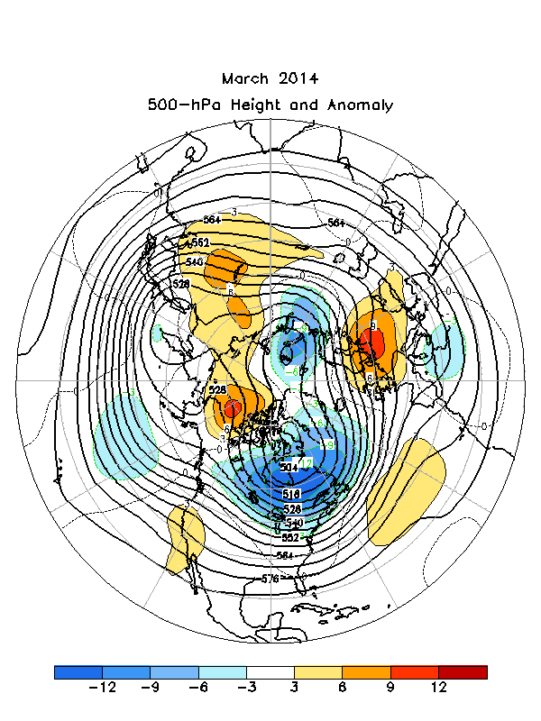
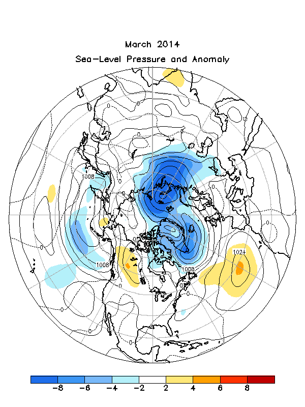
The 500-hPa circulation pattern during March featured below-average heights over eastern Canada, the high latitudes of the North Atlantic, and northwestern Russia, and above-average heights over the central North Atlantic, Europe, eastern Asia, and northern Alaska and the Beaufort Sea Figure 5. The SLP and Anomaly map for March depicts abnormally low sea level pressure in northwestern Russia and much of Greenland/Iceland Figure 6.
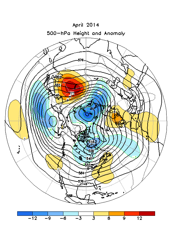
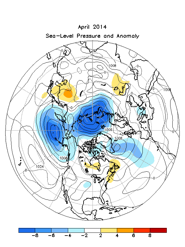
The month of April was characterized by below average 500 hPa heights over the central North Pacific, central Canada, and the polar region, and above average heights over Europe and eastern Asia Figure 7. The most pronounced features on the SLP and Anomaly map included abnormally low SLP over much of far northern Russia and the Asian side of the Arctic Ocean, the northern North Pacific and Bering Sea, and middle and high latitudes of the North Atlantic Figure 8.
According to the National Climatic Data Center, a selection of significant weather related events for the March-April period included the coldest March on record for Vermont (5C below average), nearly two-thirds of the Great Lakes remained frozen by early April (impacting commercial shipping), and rains in the Pacific Northwest helped trigger a landslide near Oso, WA, causing at least 30 fatalities Reference 2. Alaska was warm and dry in April, contributing to the 6th smallest April snow cover extent on record for the state Reference 3.
The Tropics
ENSO-neutral conditions persisted through March and April 2014. Sea surface temperatures (SSTs) were below average across the eastern equatorial Pacific and above average over the central Pacific (March), and above average across much of the eastern and central equatorial Pacific (April). The latest monthly Nino indices for the Nino 3.4 region were -0.2C (March) and +0.2C (April). A down welling oceanic Kelvin wave produced a significant subsurface warming across the central and eastern equatorial Pacific during March and April, and the depth of the oceanic thermocline (20C isotherm) was above average across the central and eastern equatorial Pacific. Equatorial low-level easterly trade winds were below average across the Pacific (March) and near-average (April). Tropical convection remained enhanced over the central equatorial Pacific and suppressed across Indonesia and the western Pacific (March), and enhanced over the west-central equatorial Pacific (April).
References
Much of the information used in this article originates from the Climate Diagnostics Bulletin archive: http://www.cpc.ncep.noaa.gov/products/CDB/CDB_Archive_html/CDB_archive.shtml
Back to top